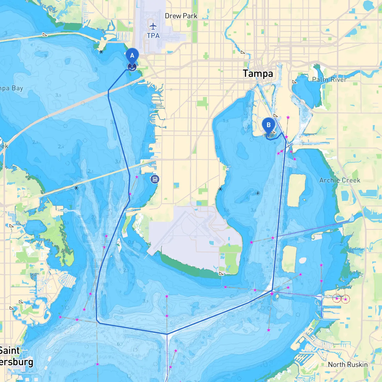
### Pilotage Plan for a Boat Trip from Tampa, Florida to Tampa, Florida**Route Overview**This itinerary takes you on a delightful loop around Tampa Bay, offering a perfect blend of scenic views, excellent navigational aids, and safe harbors. This route is particularly well-suited for recreational boaters looking for a leisurely day on the water while remaining mindful of safety and navigational considerations.---#### Starting Point: Tampa, Florida (Coordinates: -82.547921081, 27.951735708)**Departure Considerations:**- Before you set off, ensure your vessel is seaworthy and check the weather forecast—favorable conditions will make your trip a lot smoother.- Familiarize yourself with local boating regulations, including speed zones and no-wake areas, particularly around populated waterfronts.---### Route Details**1. Tampa Bay: Entering the Waterway**As you depart from the Tampa dock, make your way towards the main channel of Tampa Bay. Keep an eye on the local navigation buoys, particularly the red and green markers that designate safe passage. **Navigational Aids:**- **Tampa Bay Main Channel:** Navigational markers here are plentiful. Keep the green buoys on your starboard side.- **Hazards:** Be cautious of shallow areas, particularly close to the marine parks along the coast.**2. Notable Points of Interest on the Bay**- **Davis Islands:** A perfect spot to stop for a quick swim or picnic. The island offers parks and beaches but stay aware of any local regulations regarding land access and activities.- **Ballast Point Park:** A great place to stretch your legs, launch a small kayak, or simply enjoy the sunset views.**Shelter Options:**- If the weather turns rough, you can take shelter in the calm waters of **Old Tampa Bay** or head to **Bayshore Boulevard**, where there are several marinas.---**3. Navigating around the South Shore**After enjoying the sights around Davis Islands and Ballast Point, you can proceed past MacDill Air Force Base. This area is heavily monitored, so be attentive to any NO WAKE zones.**Navigational Considerations:**- Use local sonar and mapping apps like Savvy Navvy to stay updated on depth and currents.- Be mindful of military operations around MacDill—keep a respectful distance from active zones.**4. Heading back to Tampa**As you loop back towards Tampa, plan your approach to the downtown area with caution as traffic can be heavier. The channel into Tampa has various commercial traffic; observe the larger vessels and adhere to their right of way.**Points of Interest:**- **Tampa Riverwalk:** If you have time, this bustling area offers vibrant waterfront dining and entertainment.---### Safety and Regulations**Local Regulations:** - Always carry a valid boating license and ensure personal flotation devices (PFDs) are on board for every passenger.- Observe speed limits, especially in no-wake zones, to protect both your boat and local wildlife.- Monitor VHF radio channels for any navigational updates or emergency notices.**Weather Contingency Planning:** - Use weather apps and stay informed about local conditions. If storms are forecasted, be prepared to seek refuge early.---### Conclusion This route around Tampa Bay is not only beautiful, showcasing the waterfront attractions and parks but is also safe and well-structured for both novice and experienced boaters. The opportunity to enjoy natural scenery while having contingency plans in place ensures a memorable boating experience. With amenities and shelter options well within reach, it makes for a perfect day trip while keeping safety at the forefront. Make sure to enjoy every moment out on the water while taking in the stunning views of this coastal gem.Don't forget to download boating apps like Savvy Navvy for effective route tracking and marina information as you set sail. Happy boating!