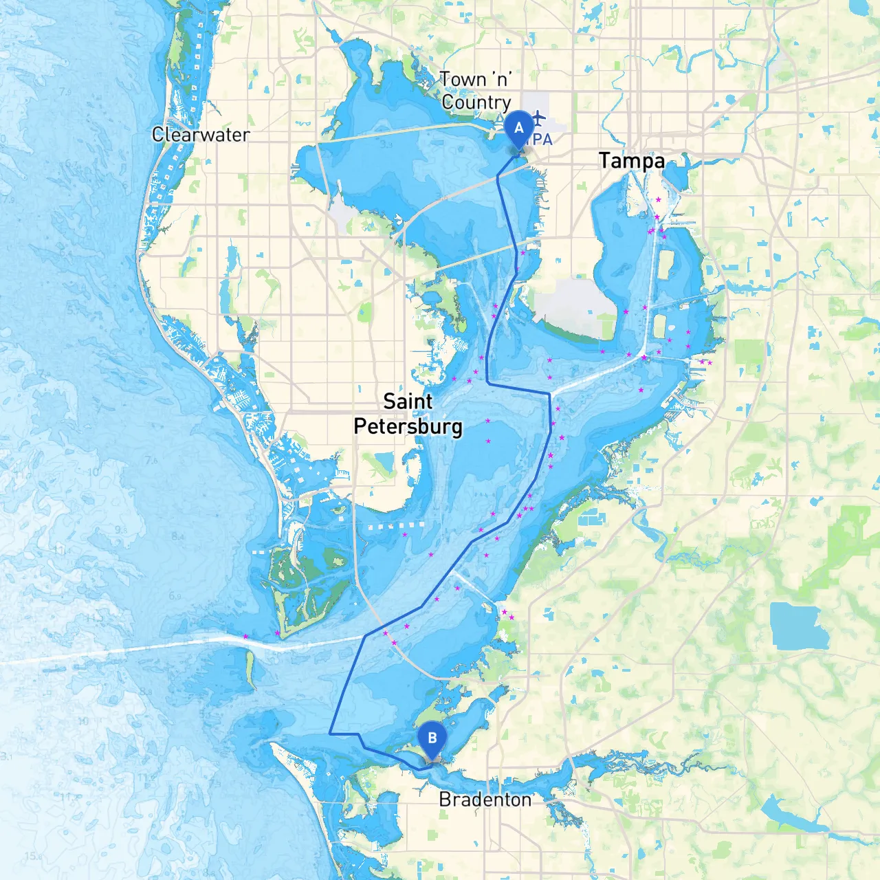
Overview:Embarking on a journey from Tampa to Palmetto offers a delightful mix of scenic vistas, interesting landmarks, and a glimpse into Florida's rich coastal landscape. This route is suitable for recreational boaters with a moderate level of experience, making it perfect for day trips or weekend getaways. Prioritizing safety while maximizing enjoyment is the key focus of our journey.
Coordinates: Long -82.5479, Lat 27.9517
Starting Point Considerations:Before you set sail from Tampa, familiarize yourself with local weather conditions. The Tampa Bay is a bustling hub, and with its extensive maritime traffic, you’ll want to be alert. Ensure that all safety equipment is onboard and operational—life jackets, flares, fire extinguishers, and a properly stocked first aid kit.
Hiding Spots: In case of unexpected weather changes, Tampa Bay has various sheltered spots, such as the Davis Islands or the calmer waters around St. Petersburg.
1. Navigating Tampa Bay: As you leave the bustling port of Tampa, it’s essential to stay vigilant in this channel full of recreational vessels and commercial shipping traffic. Use navigational aids like Tampa Bay Lighthouse (Fl W 5s 30ft) and maintain a lookout for approaching boats. Keep the Gandy Bridge to your starboard as you head toward the entrance of the bay.
2. Point of Interest: Egmont Key State Park: Approximately halfway to Palmetto, a perfect place to stop is Egmont Key—accessible by water only. It’s a historic site with old fort ruins, picturesque beaches, and a wildlife refuge. Here, boaters can get a chance to enjoy swimming, shelling, or simply soaking in the sun.
3. Navigational Aids and Hazards: As you progress, heed specific markers along the route: - Follow ICW markers carefully as you navigate the Intracoastal Waterway. - Pay attention to low tide conditions which could expose shallow areas like Hillsborough Bay. Always consult recent nautical charts for updates on buoy placements or any temporary obstructions.
4. Shelter Bays: Should inclement weather arise, the Manatee River provides a reliable and safe refuge. Numerous marinas and sheltered bays along the river can offer temporary shelter and are well-marked on maps. The Palmetto side of the river has several facilities catering to transient boaters.
Coordinates: Long -82.6167, Lat 27.5231
End Point Considerations:Upon your arrival at Palmetto, familiarize yourself with its local attractions, such as the Manatee County Historical Park. The nearby amenities provide options for dining and relaxation after your journey.
1. No-Wake Zones: Pay close attention to areas with speed restrictions, mainly around residential areas and marinas.
2. Wildlife Considerations: Both Tampa Bay and the Manatee River areas are home to an array of wildlife, including manatees. Slow down in areas where these gentle giants are known to frequent, especially during the warmer months.
3. Local Boating Apps: To enhance your navigation experience, consider leveraging technology. Apps like Savvy Navvy, Navionics, and Windy can provide real-time updates, routing assistance, and weather forecasts to ensure a safe journey.
This pilotage plan is designed to offer practical advice, focusing on safety while enjoying the wonderful journey from Tampa to Palmetto. Whether you're aiming for a tranquil day of fishing, exploring sandy beaches, or simply taking in the coastal beauty, this route captures the essence of Florida boating. Stay safe, remain vigilant, and enjoy the beautiful waters that the Gulf Coast has to offer!