
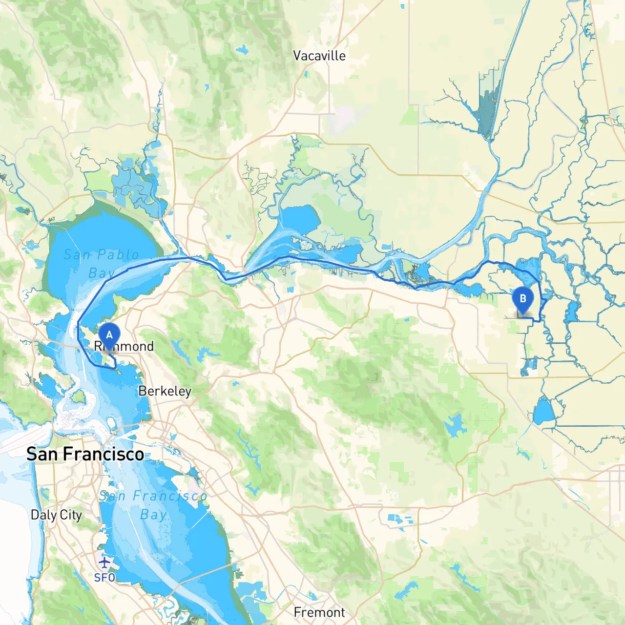
Pilotage Plan: Richmond, CA to Brentwood, CA
Starting Point: Richmond, CA Richmond is a vibrant city located at coordinates -122.3744 longitude and 37.9243 latitude, nestled in the San Francisco Bay Area. It’s known for its stunning waterfront, extensive parks, and interesting history, making it a great departure point for your boating journey.
Ending Point: Brentwood, CA Arriving in Brentwood, located at coordinates -121.6131 longitude and 37.9772 latitude, offers a picturesque view of the Delta region. Brentwood is often perceived as a quiet residential oasis with access to various recreational activities.
Your journey from Richmond to Brentwood will largely take you through the San Francisco Bay and into the Sacramento-San Joaquin River Delta. This 40-mile (approx.) route is suitable for boaters of various skill levels, though it is best suited for intermediate to experienced boaters due to the diverse conditions encountered along the way, including tidal currents and occasional shipping traffic.
As you embark from Richmond, you will want to navigate carefully through the busy waters of the Richmond Inner Harbor. Take note of the ferry traffic and recreational boats in the area. The Richmond-San Rafael Bridge is a significant landmark with a clearance suitable for most vessels. However, be mindful of the currents here. Use navigation apps like Savvy Navvy to chart your course accurately.
After passing under the bridge, you will enter San Pablo Bay. This area provides beautiful views but can sometimes be windy, so monitor the weather conditions closely. The bay is shallow in places, so be vigilant regarding depths—ideal for smaller, flat-bottomed vessels.
Shelter Opportunity: If weather conditions degrade, consider seeking temporary shelter at nearby waters such as Point Pinole or the waters around Marin Islands, where the crew can take a break or wait for the weather to clear.
As you progress, watch for the ship traffic in San Francisco Bay, especially as it intersects with the entrance to the Carquinez Strait. Follow the navigation buoys and keep an eye on marine traffic signals. The bay is a hub for commercial shipping, so maintain safe distances and keep a watchful eye out for large vessels.
Notable Points of Interest:
Important Note: Watch out for the large commercial vessels navigating through this narrow strait and give way as necessary. The Benicia-Martinez Bridge is a prominent feature here and serves as another navigational marker.
Shelter Opportunities: There are numerous marinas and anchorages along the Delta. Look for opportunities to dock at successful establishments like the Delta Marina or the Willow Berm (ideal for mooring overnight).
Regulations: Keep basic boating regulations in mind. The Delta region has specific times for speed limits, especially in slow-speed areas where wildlife is prevalent, such as near marshes and docks. Always keep an eye on signage and local guidelines.
This boating trip from Richmond to Brentwood provides an exciting mix of busy urban navigation, stunning natural scenery, and peaceful Delta waters. With thoughtful planning, awareness of surrounding conditions, and respect for the local regulations, it promises to be a safe and rewarding adventure. It’s a chance to not only transit from one city to the next but to embrace the natural beauty and the unique character of California’s waterways. Get your crew ready, and enjoy the journey!