
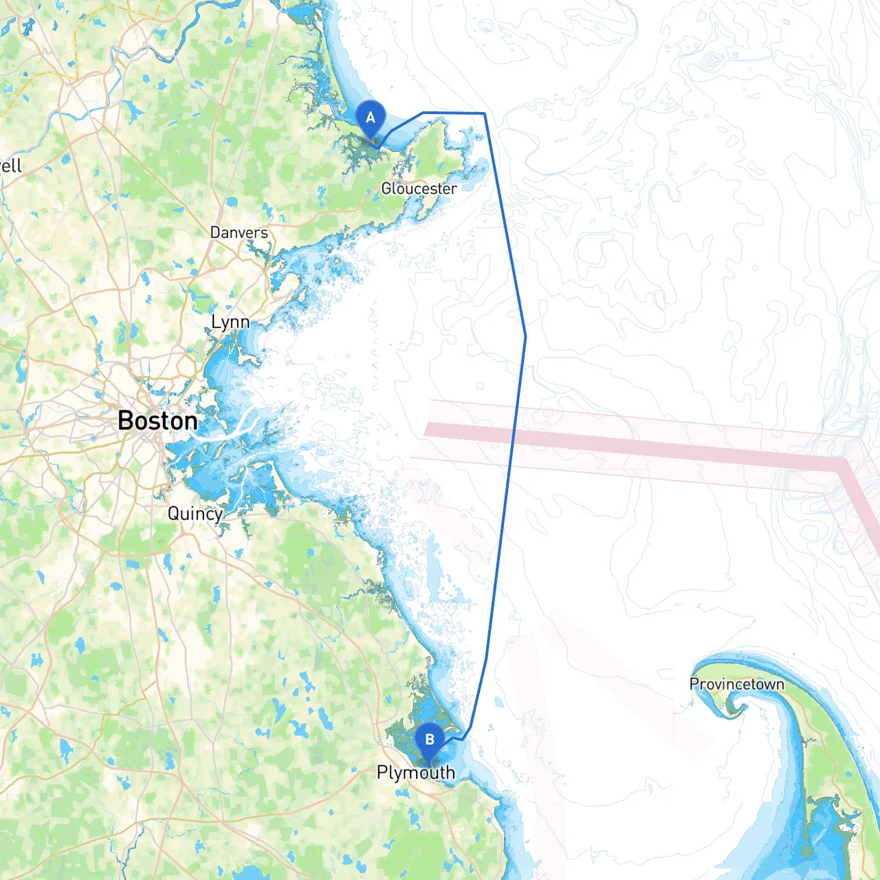
Pilotage Plan: Ipswich, Massachusetts to Plymouth, Massachusetts
Embarking on a boat trip from Ipswich to Plymouth offers a wonderful opportunity to savor the beautiful Massachusetts coastline, while navigating through a blend of serene bays, historical landmarks, and charming towns. This route is ideal for experienced boaters looking for a mix of adventure and relaxation, with ample access to shelter if weather conditions change.
Coordinates: Long: -70.7365833, Lat: 42.6656667
Before setting out, ensure you familiarize yourself with the local waters and any local conditions that might affect your trip. The Ipswich River is a great point of departure, leading to the open waters with a mix of motoring and sailing opportunities.
Distance: Approximately 5 nautical miles Estimated Time: 1 hour (allowing for typical cruising speed)
Your initial departure will take you down the Ipswich River, which is serene and presents you with beautiful views. Make sure to watch for local fishing boats and kayakers. As the river joins the open waters of the Massachusetts Bay, you’ll want to keep an eye on the navigational buoys. Pay attention to the “Red Right Returning” rule – keep red buoys on your right side as you return from the sea.
Essex Bay is a perfect spot for a quick shelter stop. This scenic bay is sheltered from the north and provides a beautiful backdrop for a relaxing lunch. You might even spot local wildlife, including lobstermen hauling their traps, as the area is rich with marine life.
Distance: Approximately 3 nautical miles Estimated Time: 30 minutes
Continuing south, you’ll turn west into the Annisquam River, venturing through narrow, comfortably sheltered waters. The river is a perfect picture of New England’s charm, flanked by quaint houses and rich vegetation.
Keep an eye on the water depth, particularly as you approach the Annisquam Canal, which can have localized shoaling. The canal is marked, but make sure your charts are updated. Wind conditions can also change rapidly, so be prepared to adjust your sails or speed.
Distance: Approximately 4 nautical miles Estimated Time: 1 hour
As you emerge from the river, you'll pass into Gloucester Harbor, a historic fishing port rich with culture and history. Signs of the area's storied maritime past are all around.
This stop offers plenty of excitement. You can dine on fresh seafood at local establishments or visit the famous Fishermen's Memorial. The harbor itself is bustling, and there are plenty of facilities for refueling and restocking supplies.
Distance: Approximately 10 nautical miles Estimated Time: 1.5 hours
Leave the hustle of Gloucester enjoying the north flank of Cape Ann. This leg of the trip is particularly scenic. Keep an eye out for local sailboat races taking place during the summer months.
Distance: Approximately 14 nautical miles Estimated Time: 2 hours
As you pass Marblehead, be mindful of the famous Marblehead Light, a historic landmark. As you get closer to Boston Harbor, traffic will increase significantly, and awareness of large vessels will require extra vigilance.
Distance: Approximately 25 nautical miles Estimated Time: 4 hours
This final stretch leads you into the bustling waters of Plymouth. The entrance to Plymouth Harbor is adequately marked with navigational aids and offers plenty of shelter from north and east winds.
Arriving in Plymouth brings you face-to-face with some of the most iconic landmarks in US history, including Plymouth Rock and the Mayflower II. Take some time to drop anchor and explore the vibrant waterfront area, filled with restaurants, shops, and historical attractions.
This carefully planned route from Ipswich to Plymouth provides a unique blend of safety and adventure, perfect for experienced boaters looking to embrace the coastal charm of Massachusetts. Enjoy your journey, stay vigilant, and appreciate the beauty of the waters you navigate. Safe travels!