Pilotage Plan from East Boston, MA to Danvers, MA
Overview
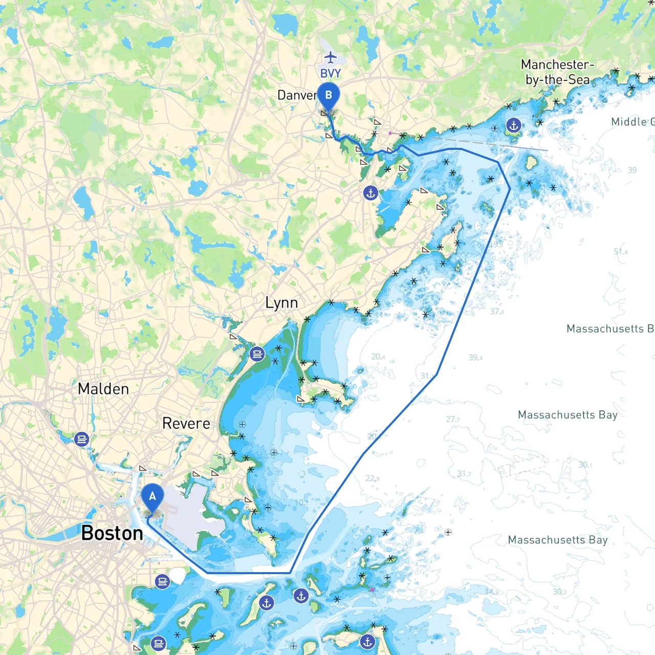
Embarking on a boating trip from East Boston to Danvers presents a fantastic opportunity to explore the scenic beauty and rich maritime history of Massachusetts' coastline. This route is predominantly suitable for day cruisers and powerboaters, allowing for leisurely navigation while keeping safety a top priority. Along the way, you'll not only enjoy the beautiful vistas but also have access to quaint harbors and points of interest.
Departure Point: East Boston, MA (Coordinates: -71.0338, 42.3636)
Your journey kicks off in East Boston, a lively neighborhood with a significant maritime culture. Before setting sail, ensure your vessel is properly equipped with navigation tools, safety gear, and adequate fuel for the trip ahead.
Route Overview
- Distance: Approximately 16 nautical miles
- Estimated Duration: 2-3 hours, depending on speed and weather conditions
Notable Stops and Shelters
: As you navigate through Boston Harbor, you may choose to make a brief stop at the Broad Sound entry, where you can take in the sights of the picturesque coastline. This area also provides ample opportunities to anchor should the weather change unexpectedly.
2. Lynn Harbor: Just after departing from the harbor, Lynn offers a safe haven with good protection from northeast winds. The Lynn Beach and Lynn Shore Reservation are perfect for a quick dip or beach stroll.
3. Marblehead Harbor: A charming historic harbor worth a visit, Marblehead boasts gorgeous scenery and a vibrant town center. You can stop for lunch at one of the waterfront cafes before continuing your journey to Danvers.
Key Navigation Features
- Approaching the North Channel: After leaving East Boston, you'll ultimately want to navigate through the North Channel. Keep a vigilant watch for commercial shipping traffic and always adhere to local traffic regulations.
- Navigational Aids: Pay close attention to navigational marks such as buoys and lighthouses which help guide your path. Notable aids include:
-
: A critical marker that advises of underwater hazards, particularly to the southeast. -
Beverly Harbor Channel Buoys
: Utilize these aids for safe passage into Beverly as you approach Danvers.
Local Regulations
- Speed Limits: Be mindful of the established speed limits in harbor areas and narrow channels, particularly within Marblehead and Lynn Harbors.
- Fishing Regulations: If you plan to fish along your journey, make sure to familiarize yourself with local regulations and license requirements.
- No-Wake Zones: Observe all “No-Wake” zones particularly near harbors and residential areas to ensure safety for both your vessel and those in proximity.
Arrival Point: Danvers, MA (Coordinates: -70.9186666667, 42.5571666667)
Upon entering Danvers, you'll find an array of amenities ranging from waterfront parks to excellent dining options. Danvers offers a welcoming atmosphere and the beautiful Danvers Harbor, where your journey concludes.
Safety Recommendations
- Weather Watch: Always check the weather forecast before departure and maintain a real-time check on conditions using marine apps. I recommend savvy navvy for its user-friendly interface and dependable real-time weather updates.
- Safety Gear: Ensure all safety equipment is onboard, including personal flotation devices (PFDs), fire extinguishers, and a first-aid kit.
- Communication: Keep a reliable means of communication, such as a VHF radio or a fully charged mobile phone with boating apps.
Conclusion
This route from East Boston to Danvers is not only a voyage through beautiful waters but also an excellent way to embrace the maritime culture of the Massachusetts coast. With sufficient planning and adherence to safety guidelines, you're sure to have a memorable and enjoyable outing on the water.