Pilotage Plan: NYC to Laurence Harbor, NJ
Overview
This itinerary takes you from the bustling waters of New York City to the serene shores of Laurence Harbor, NJ, offering a blend of fascinating urban scenery, important navigation considerations, and opportunities to enjoy nature, all while emphasizing safety. This trip is ideal for day cruisers and experienced boaters alike, as it combines the excitement of navigating through busy waters with access to sheltered bays and scenic spots.
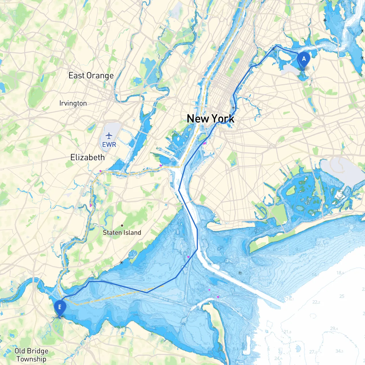
Starting Point: New York City, NY
- Coordinates: Longitude -73.8505193, Latitude 40.7742076
- As you depart from the vibrant cityscape, you'll be surrounded by iconic landmarks, including Ellis Island and the Statue of Liberty, visible as you head southward out of the harbor.
Key Hazards and Navigation Considerations
- Tidal Currents: Pay attention to tidal currents in the East River and surrounding areas. These can be particularly strong around the tides, which affect your speed significantly.
- Commercial Traffic: The area is heavily trafficked with ferries, cargo ships, and recreational boats. Use caution by maintaining constant situational awareness and frequently scanning for larger vessels.
Points of Interest and Safe Shelters Along the Way
: A quick detour into the Hoboken marina area provides a great stop for provisions or a bite at one of the many waterfront eateries. It’s an excellent spot for stunning views of Manhattan.2.
: Popular for boaters, this park features docking facilities and beautiful views of the skyline and the Hudson River. It offers an ideal sheltered area should weather conditions become unfavorable.3.
: A great natural harbor that provides excellent shelter from most winds. It's a fantastic spot to anchor and take a swim or enjoy the natural scenery. Be cautious as it can get busy with powered boats on weekends.
Navigating to Laurence Harbor, NJ
- Leaving New York Harbor: Departing from your starting point, navigate through the Upper New York Bay, heading toward the Verrazzano-Narrows Bridge.
- Waypoints: Follow the Hudson River to the entrance of Sandy Hook Bay, with a waypoint at the Statue of Liberty (coordinates: Longitude -74.0445, Latitude 40.6892) as a reference point.
- Navigational Aids: Keep an eye out for buoys marking the shipping channels. Notably, the Ambrose Channel must be navigated cautiously, following US Coast Guard markers.
Arrival at Laurence Harbor, NJ
- Coordinates: Longitude -74.2561667, Latitude 40.4606667
- As you approach Laurence Harbor, watch for typical New Jersey shore hazards, including various small craft and fishing operations in the area. Adhere to local navigation rules and be wary of the ebbing currents as you enter the Raritan Bay.
Local Regulations and Safety Tips
- Waste Disposal: Be mindful of waste regulations in New Jersey’s coastal waters. Use pump-out stations where available.
- Speed Limits: Observe local speed limits in designated no-wake zones, particularly in marinas and near shorelines.
- Safety Equipment: Ensure you have all necessary safety gear onboard—life jackets, fire extinguishers, a first aid kit, and a VHF radio for emergencies.
Recommended Boating Apps
- Savvy Navvy: This app is particularly useful for route planning and includes information on tides and charts, helping you stay informed and safe on your journey.
- Windy: An excellent tool for monitoring weather conditions.
- Navionics: Great for nautical charts, this app also provides updates on local hazards.
Conclusion
This journey from New York City to Laurence Harbor promises to be an enjoyable and safe trip for any boater, navigating through exciting waters while providing ample opportunities for rest and exploration. By adhering to safe boating practices and utilizing the resources discussed, you’re set for an excellent adventure on the water!