Pilotage Plan for a Boat Trip from Wilmington, NC to Hampstead, NC
Overview
This trip is a delightful short cruise along the scenic waterways of North Carolina, suitable for experienced and intermediate boaters looking for a blend of natural beauty and coastal charm. Notably, the route allows you to explore charming bays and enjoy the serenity of the local coastline, while keeping safety paramount.
Route Description
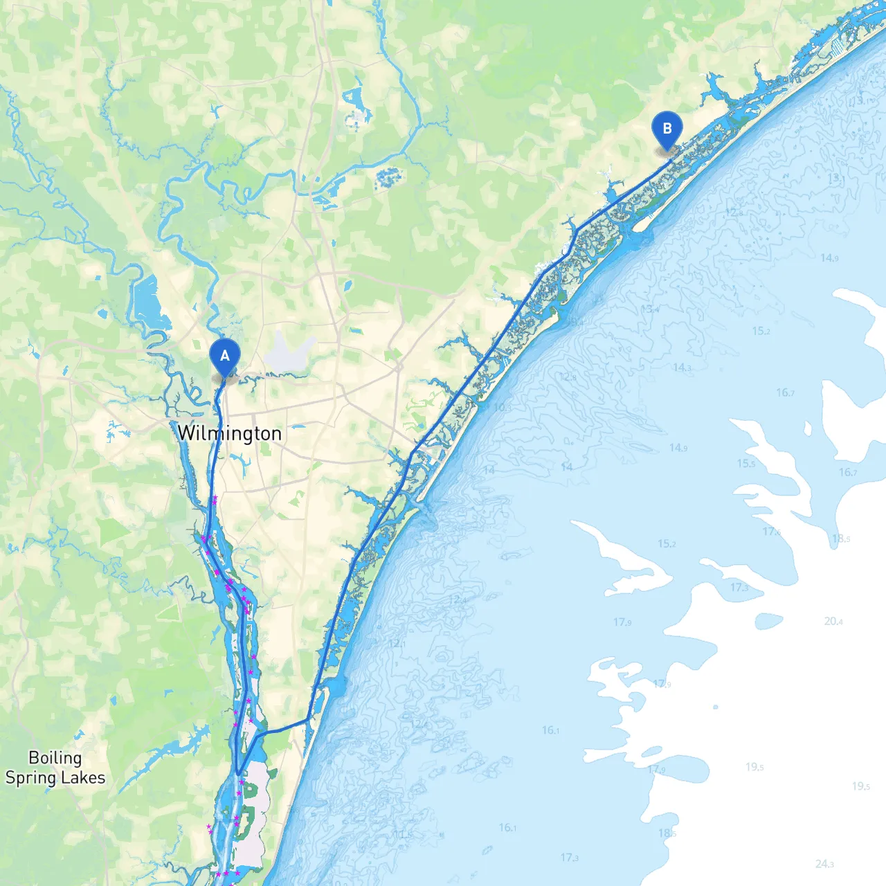
- Starting Point: Wilmington, NC (Coordinates: -77.94805, 34.255)
- Ending Point: Hampstead, NC (Coordinates: -77.6375333333, 34.3865333333)
The journey from Wilmington to Hampstead covers approximately 20 nautical miles up the Intracoastal Waterway (ICW) and is a mix of both protected waters and open sections.
Points of Interest and Shelters
As you embark on your journey, consider these notable points where you can either anchor for a break or simply enjoy the beautiful surroundings:
1. Masonboro Inlet: About 8 miles southwest of Wilmington, this inlet offers a splendid view of the barrier islands and is a fantastic spot for wildlife watching. It's also a haven for sandy beaches. Be cautious of shifting sands and tide changes here.
2. Figure Eight Island: As you navigate northward, keep an eye out for the serene, private Figure Eight Island. The homes here are stunning, and if conditions are calm, you might want to slowly cruise around the island and absorb its beauty from the water.
3. Side Creek Shelters: Throughout your trip, there are side creeks and smaller coves where you can temporarily anchor if the weather changes unexpectedly. Always scan ahead for these natural features, as they might provide shelter from wind and waves.
Important Navigational Aids
The route generally follows the ICW, making it easier to navigate, but here are essential navigational aids and points to heed:
- Markers and Buoys:
Watch for ICW markers; these channel markers are critical for maintaining the safest passage. Stick to the red right returning rule. Familiarize yourself with buoy colors and what they indicate about the channel ahead.
- Bridge Openings:
You'll encounter a few drawbridges in this segment. Notable bridges include the
Figure Eight Island Bridge
; check the timings for openings particularly if you plan to travel during peak hours.
- Depths and Tides:
Be mindful of tidal influences, particularly in shallower areas. The waters reach their lowest very early in the morning and right before dusk. Always consult your chart plotting app for up-to-date depth reports—it’s prudent to have an up-to-date nautical chart.
Local Restrictions and Regulations
- Speed Limits and No-Wake Zones:
Throughout Wilmington, especially near marinas, remember to observe speed limits and no-wake zones to protect wildlife and shoreline residents.
- Wildlife Concerns:
The area is home to a variety of protected wildlife, including seasonal bird migrations and marine species. Be mindful when anchoring to avoid disrupting their habitats.
Safety Recommendations
- Emergency Equipment:
Ensure you have life jackets for all passengers, a first aid kit, fire extinguisher, and working flares—check each vessel component before departure.
- Weather Monitoring:
Check forecasts before leaving the dock and utilize reliable apps like
for real-time updates on changing weather conditions.
Have a VHF radio for communication with other boats or emergency services. Stay informed on channel 16 for emergencies; it’s the primary way of communicating in marine emergencies.
Conclusion
This trip from Wilmington to Hampstead is not only an escape into natural beauty but also offers plenty of safety features along the way. It is tailored for boaters with a penchant for peaceful cruising through protected waters, providing immediate opportunities for shelter if needed. With vigilance and preparation, you’re set for a truly enjoyable and safe experience on the water. Happy sailing!