
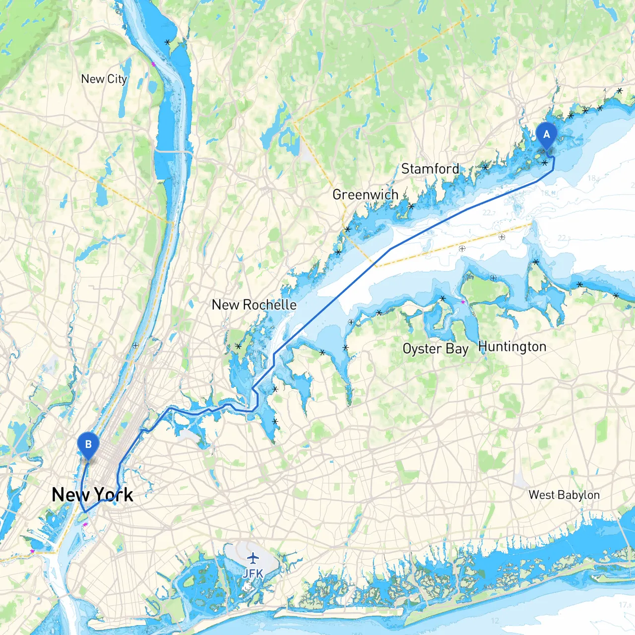
Embarking from Westport, Connecticut, to New York City provides an exhilarating experience of both natural beauty and urban excitement. This journey, primarily along the Long Island Sound and the East River, offers a mix of sheltered bays, historical landmarks, and vibrant waterfronts. While this trip is perfect for intermediate to advanced boaters, there's plenty to enjoy for those ready to engage with their surroundings and navigate through some bustling waterways.
1. Departure from Westport, CT - Starting Coordinates: Latitude 41.0688, Longitude -73.3779 - Westport offers ample facilities for final preparations, including fuel, provisions, and repair services. Before heading out, check the weather forecast, as conditions can change rapidly.
2. First Leg: Westport to Norwalk Harbor (Approx. 7 nautical miles) - Navigate eastward and keep watch for navigational buoys marking the channel. Norwalk Harbor is well-marked and provides a safe haven should weather conditions deteriorate. - Point of Interest: Norwalk Maritime Aquarium. A great stopping point for families, the aquarium showcases regional marine life and offers walkable waterfront attractions.
3. Norwalk to Stamford (Approx. 5 nautical miles) - Continue east, favoring the southern side of the channel where depths remain favorable. Stamford has both public and private docks and plenty of options for dining or enjoying the local marina scene. - Sheltering Options: Stamford Harbor is another good refuge in case of sudden weather shifts.
4. Stamford to Greenwich (Approx. 4 nautical miles) - As you proceed to Greenwich, you will experience stunning views of upscale homes lining the coast. Be mindful of any local regulations regarding speed limits, particularly in no-wake zones. - Point of Interest: The Bruce Museum houses art and natural history exhibitions and is situated a short distance from the water.
5. Greenwich to New Rochelle (Approx. 12 nautical miles) - This segment puts you back out into the open water of Long Island Sound, heading slightly southward. The open water can be prone to swells, so stay alert. New Rochelle offers safe docking opportunities, along with good restaurants and shops. - If you find yourself facing unfavorable conditions, the nearby bays of Long Island Sound provide plenty of space to maneuver safely.
6. New Rochelle to Throgs Neck Bridge (Approx. 8 nautical miles) - Now transitioning into busier waters, navigate towards the Throgs Neck Bridge while paying heed to commercial shipping traffic. Be particularly vigilant about the charts and radar information here. - Throgs Neck Bridge is a significant landmark, hinting that you're nearing New York City.
7. Throgs Neck to East River (Approx. 4 nautical miles) - After passing under the bridge, you’ll be entering the East River. Be cautious of the tidal currents. Space can get tight here, especially near the Bronx and Queens. Ensure you’re equipped with up-to-date charts or a reliable app, like Savvy Navvy, for real-time navigation.
8. Final Leg: East River to Manhattan (Approx. 4 nautical miles) - As you head towards Manhattan, key navigational points to recognize include Rikers Island and the bustling waterfronts. The southern approach to Manhattan provides stunning skyline views. - Point of Interest: Consider stopping at one of the public docks, such as the 79th Street Boat Basin, allowing for more exploration of the city.
This route from Westport to New York City is not just a means of transportation; it's a nod to maritime adventure interspersed with rich culture along the coast. Emphasizing safety and preparation creates a balanced experience of leisure and excitement, making it an ideal charter for both experienced boaters and those looking to enhance their skills while soaking in the sights of coastal New England and metropolitan majesty. Safe travels!