
Pilotage Plan: Warwick, Rhode Island to Shelter Island Heights, New York
Overview
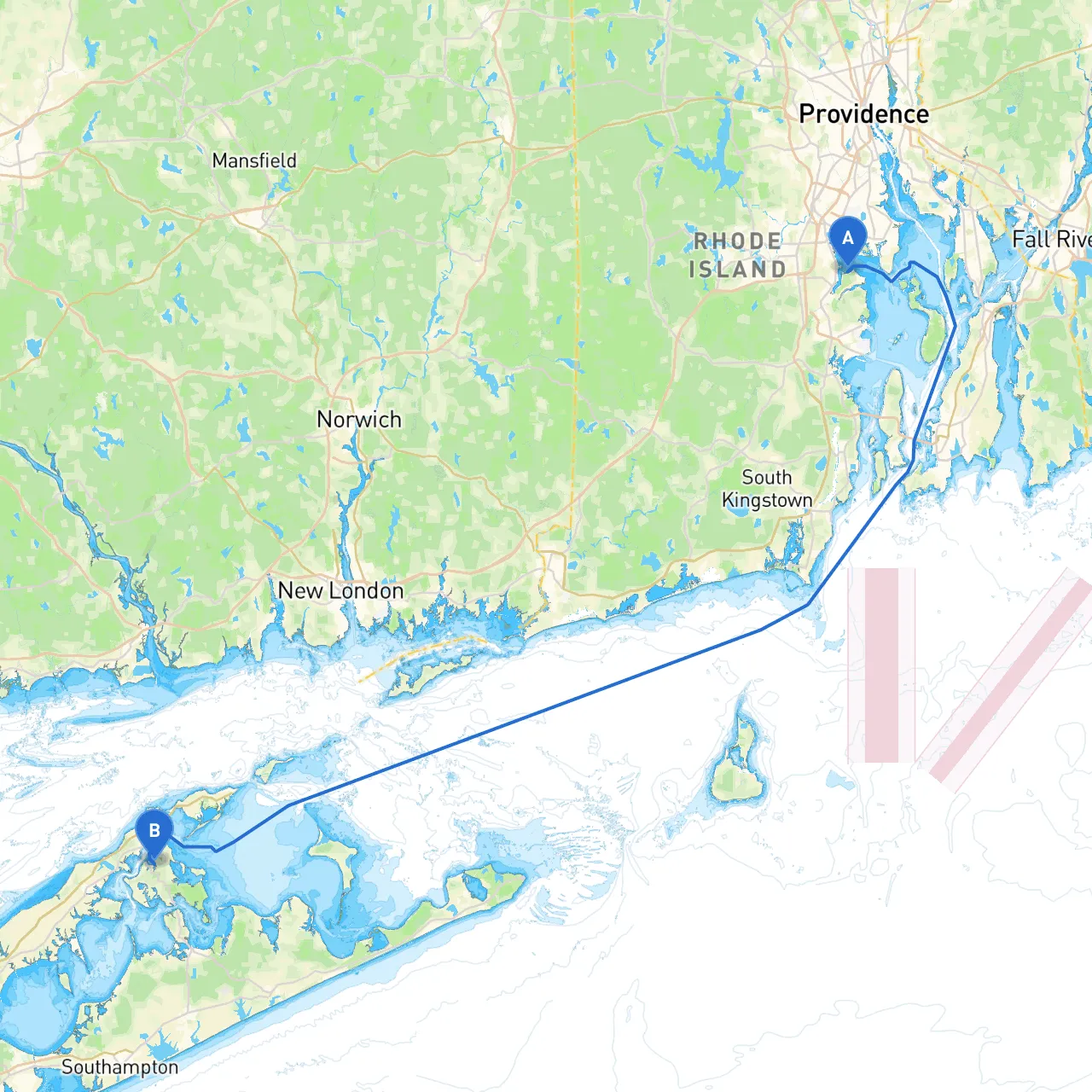
This route from Warwick, Rhode Island, to Shelter Island Heights, New York, spans approximately 35 nautical miles, navigating through picturesque New England waters. Perfect for cruising sailors and powerboaters alike, this trip offers a delightful mix of scenic views, sheltering bays, and charming coastal towns. While fostering adventure, it prioritizes safety with various stopping points and navigational aids along the way.
Section 1: Departure from Warwick, Rhode Island
Starting Point: Warwick, Rhode Island Coordinates: Long/Lat -71.4331, 41.6693
As you depart from Warwick, be mindful of the local boating traffic and secure all gear aboard before casting off. Transition through the shallow waters of Greenwich Bay and keep an eye on local fishing boats prevalent in this area.
Recommended Stop: Greenwich Cove Located just a short distance from your departure point, Greenwich Cove provides a calm anchorage where you can restock on supplies or stretch your legs on charming waterfront trails.
Section 2: Navigating Narragansett Bay
As you head east, enter Narragansett Bay, taking cautious note of the various navigation aids. Key markers to look out for include the East Passage Light and the Rose Island Light Station, both crucial to ensuring a safe passage through these often-busy shipping lanes.
Navigational Considerations:
Section 3: Historic Newport
As you navigate further along from the bay, you will approach Newport, known for its stunning mansions and vibrant maritime history. Newport Harbor provides excellent facilities if you wish to dock and explore. Make sure to visit the breathtaking Cliff Walk, or enjoy a meal at one of the many waterfront restaurants.
Recommended Stop: Newport Harbor Here, you can find moorings and transient slips if you wish to spend the night. The harbor is a bustling hub of boating activity and offers good shelter from adverse weather.
Section 4: The Journey Through Long Island Sound
Leaving Newport and grabbing a course for Long Island Sound, you’ll soon pass the striking coastline of Jamestown, which can be a delightful sight. As you approach the mouth of the Sakonnet River, ensure to follow the marked channel carefully, keeping a watchful eye on the local fishing vessels.
Important Venue: Sakonnet Point Consider this can be a diversion point — offering safe harbor in case of inclement weather. Keep the Sakonnet Lighthouse in sight as a navigational aid while nearing the river mouth.
Section 5: Crossing to Shelter Island Heights
Set your course directly towards Shelter Island Heights, navigating through the beautiful Greenport Harbor. Roughly mid-way, the area of Peconic Bay is ideal for a brief respite or even swimming if the weather permits.
Arriving Considerations:
Section 6: Destination - Shelter Island Heights, New York
End Point: Shelter Island Heights, New York Coordinates: Long/Lat -72.3445, 41.0853
Upon your arrival, Shelter Island Heights offers multiple mooring options and docking facilities. This serene area is known for its quaint charm and outdoor activities. This is a great location for hiking, biking, or simply soaking in the beauty of the area.
Final Note on Safety: Ensure your vessel is equipped with all safety gear as mandated by local regulations: life jackets, flares, and a first aid kit. A recommended app to help with navigation along this route is savvy navvy, which will provide real-time data on tides, waypoints, and hazards, enhancing your voyage experience.
This boating adventure promises a delightful escape, combining scenic landscapes and safety precautions perfectly. Whether you're an experienced sailor or a leisure boater, this route offers opportunities for fun while ensuring that safety remains paramount. Happy boating!