Pilotage Plan from Warwick, Rhode Island to Providence, Rhode Island
Route Overview:Embarking on a journey from Warwick, Rhode Island, to Providence is not only an opportunity to experience the beauty of Narragansett Bay, but also allows for various points of interest along the way. This route is suitable for recreational boaters of all skill levels, offering a mix of scenic views, accessible harbors, and safe havens should weather conditions change unexpectedly.
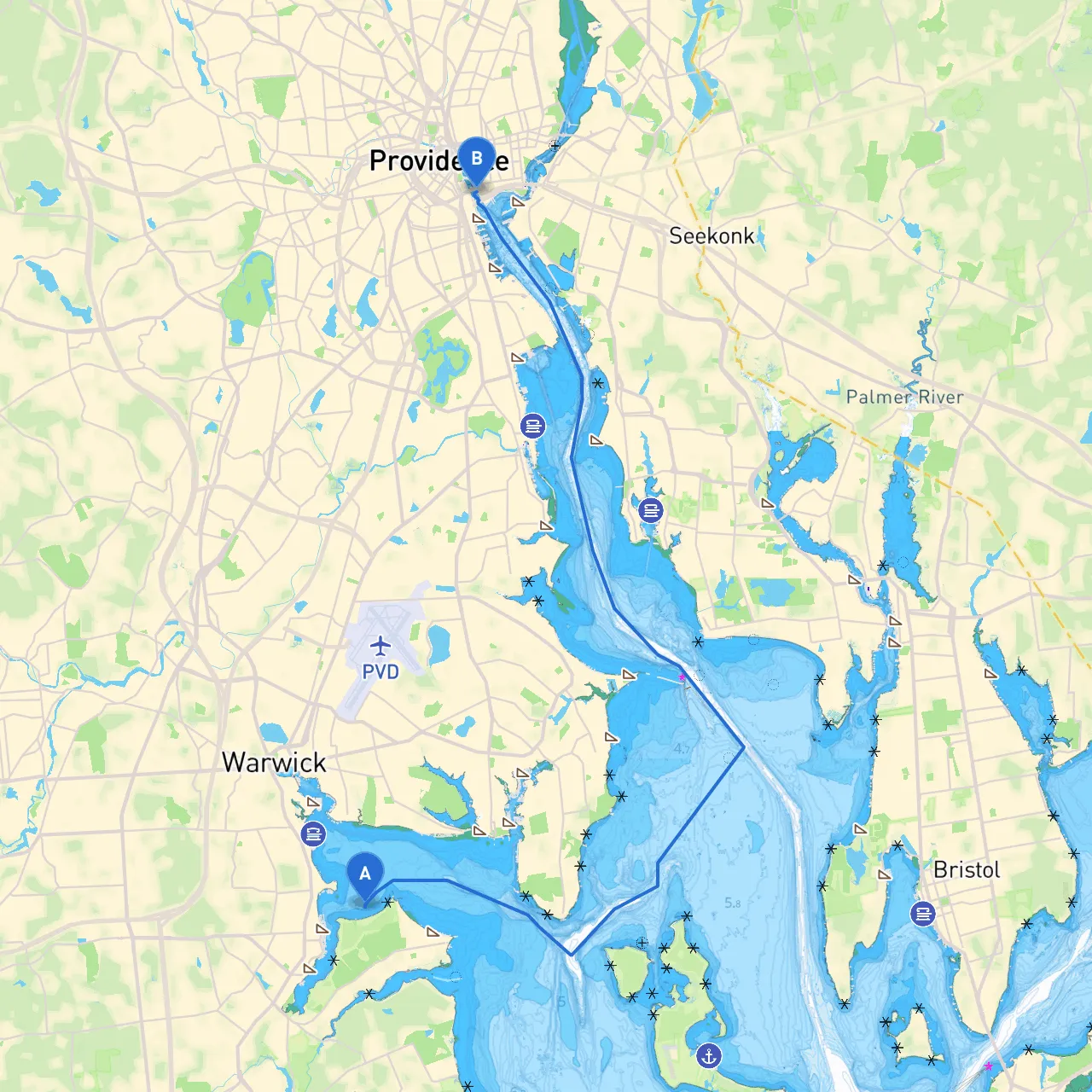
Starting Point:
- Location: Warwick, Rhode Island
- Coordinates: Longitude -71.43319, Latitude 41.66928
Ending Point:
- Location: Providence, Rhode Island
- Coordinates: Longitude -71.4023, Latitude 41.8175
Sections of the Route
1. Departing Warwick Harbor:
As you leave Warwick Harbor, it's important to be aware of local boating regulations. The harbor is well-marked with navigational aids, including buoys and lights. Ensure you're familiar with the area, especially keeping an eye on the incoming and outgoing yacht traffic.
Safety Tip: Always check the local weather before departure. The winds can pick up, especially in open waters, and having a plan can make all the difference.
2. Navigating the West Passage:
From Warwick, head southwest into the West Passage of Narragansett Bay. Look out for the back channel markers that lead through the area. The West Passage is less congested than the East Passage, making it an ideal route for those wanting little traffic.
- Hazards to Consider: Watch out for shifting sandbars and shallow areas. Use a depth finder regularly to ensure you remain in safe water depth as you weave through islets and shallow spots.
3. Points of Interest & Shelter Bays:
- Apponaug Cove: Just a bit to the north, this cove provides a serene spot sheltered from strong winds. It's a great place to drop anchor for a quick break and enjoy nature.
- Bayside Park: Located on the eastern shore, it offers a perfect landing for families. You can enjoy picnicking or take a stroll along the water's edge.
4. Approaching Narragansett Bay:
As you enter the broader parts of the Bay, navigational aids become critical, especially with potential busy channels. Pay attention to nearby fishermen, as well as commercial traffic including ferries and larger vessels that frequent the Bay.
- Important Buoys: Familiarize yourself with the channel buoys, particularly at the entrance and exit points. Use your charts to avoid navigational hazards near the bridge and check ferry schedules, as they share this passage and may have the right of way.
5. The Final Approach to Providence:
As you near Providence, the scenery transforms, making way for the city skyline. The Providence River will guide your way into the heart of the city.
- Regulation Notices: Make sure you observe all speed limits in the River, especially near public docks and marinas. The close proximity to the docked vessels requires slower speeds for safety.
Helpful Shelters & Attractions
- Bayside Marina: If the weather changes, this marina provides ample docking space and facilities for boaters.
- WaterFire Festival: If your trip coincides with summer evenings, you might catch the famous WaterFire installation in Providence—an artistic display of bonfires along the river.
Safety & Navigation Apps
Before setting out, ensure your communication devices are functioning properly. Essential apps like
can offer real-time updates on tides and weather patterns, helping you plan your trip effectively. Other notable apps include Navionics for charts and NOAA for weather advisories.
Conclusion
This route from Warwick to Providence is not just a journey across the water; it’s an invitation to explore the cultural and natural beauty of Rhode Island. Vigilance and preparation will ensure a safe passage, making your trip enjoyable and memorable. Embrace the views, enjoy the marine life, and take the opportunity to decompress in nature as you navigate through this beautiful bay. Happy boating!