Pilotage Plan: Staten Island, NY to Red Bank, NJ
Route OverviewThis pilotage plan outlines a scenic cruising route from Staten Island, New York, to Red Bank, New Jersey, that showcases the stunning waterways of the NY/NJ Harbor Estuary. This journey is perfect for seasoned boaters and leisure adventurers, offering a blend of picturesque views, opportunities to explore, and well-marked navigational aids ensuring a safe trip. Given the proximity to urban areas and local waterways, this route is most suitable for experienced boaters comfortable navigating traffic while also being mindful of safety measures.
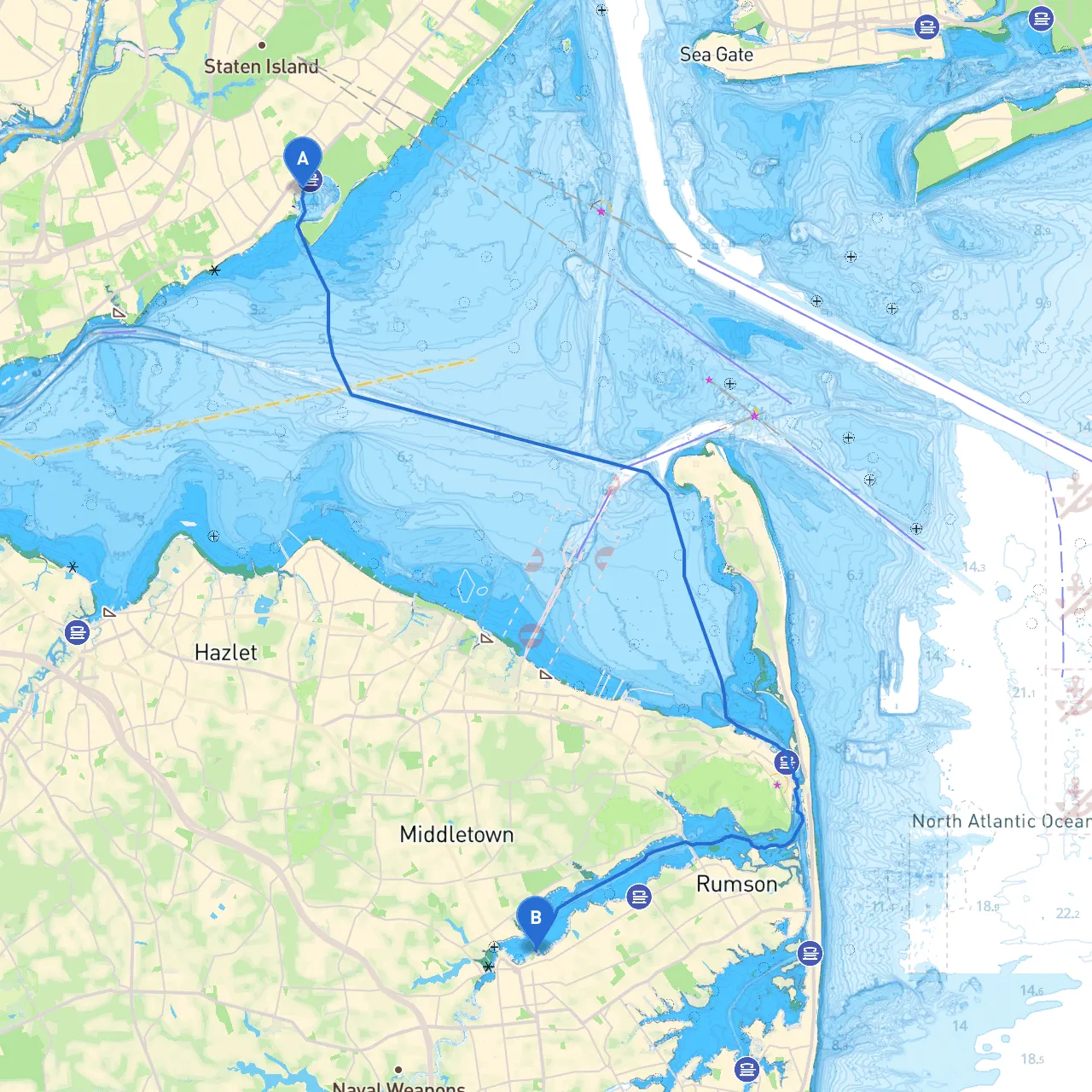
Leg 1: Departure from Staten Island
Starting Point: Staten Island, NY (Latitude: 40.5428, Longitude: -74.1398)
- Insights: Begin your departure from one of Staten Island's marinas. Make sure to check the weather conditions and get familiar with local regulations regarding tides and currents.
Hazards and Navigational Aids
- As you leave Staten Island, you’ll need to be aware of the shipping lanes leading in and out of New York Harbor. The busy Port of New York and New Jersey is filled with large vessels, so maintain a proper lookout and follow the marked channels.
- Keep your VHF radio handy, monitoring Channel 16 for any traffic and navigational advisories.
Points of Interest
The Staten Island Ferry Terminal
- A great view of the ferry operations and Manhattan skyline.2.
– An impressive historic site located on the Staten Island side of the Verrazzano-Narrows Bridge.
Leg 2: Navigating The Narrows and Hudson River
Navigational Route
- From Staten Island, head northeast toward the Verrazzano-Narrows Bridge. Stay in the center of the channel to avoid shallow waters.
- After passing under the bridge, you will enter the Upper New York Bay. Continue toward the Hudson River, ensuring to navigate carefully around the bustling shipping channels.
Waterway Regulations and Restrictions
- Keep a lookout for designated navigational markers like buoys and lighthouses along the Hudson. Note that commercial vessels have the right of way, especially within the shipping lanes.
Shelter Points Along The Route
- Haven Ports/Bays: If you encounter rough weather or mechanical issues, Hoboken Cove or Weehawken can provide good anchorage options. They can serve as excellent stopovers, offering access to local amenities and shelter.
Leg 3: Approaching Red Bank
Final Approach
- As you make your way north, you will enter the Raritan Bay, characterized by a busy boating community.
- Watch for navigation aids indicating shallow areas and keep an eye on the tide - they can have a significant impact on your navigation as you near the "Navesink River".
Important Points of Interest1. Battery Park - A picturesque area with views of the Manhattan skyline that makes for great photo opportunities.2. Sandy Hook National Park - Wonderful for a short detour; offers beaches and recreational activities.
Final Destination: Arriving in Red Bank, NJ
Ending Point: Red Bank, NJ (Latitude: 40.3553, Longitude: -74.0642)
- When approaching Red Bank, follow the Raritan River to your destination. The river becomes narrow, and care must be taken in terms of speed and navigation. Remember to adhere to local speed limits once inside the Red Bank area.
Recommended Apps
For a smoother journey and navigational assistance, consider using savvy navvy, which provides real-time weather information, detailed charts, and route planning tools. Other helpful apps include Navionics and NOAA Weather for forecasts.
Conclusion
This route from Staten Island to Red Bank is not just a path across the water—it's an exploration filled with sights to behold and experiences to enjoy. Safe navigation, awareness of local maritime regulations, and having access to shelter and amenities along the way make this trip not only enjoyable but also prudent. Happy cruising!