
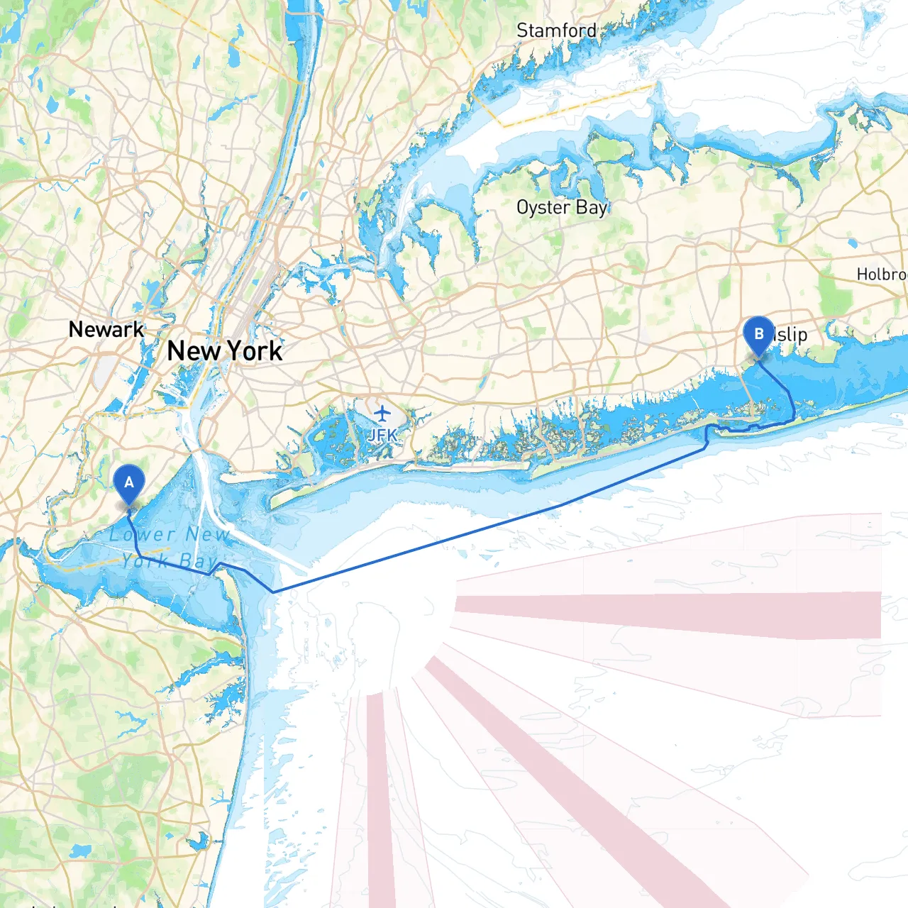
Pilotage Plan from Staten Island, NY to Bay Shore, NY
Starting Point: Staten Island, New York Your journey begins at the coordinates of Staten Island, a vibrant borough of New York City known for its parks and waterfront views. Before departure, check the local weather forecasts and conditions, as this will provide crucial insight into your navigation.
Route Overview This boat trip presents an exhilarating route spanning approximately 30 nautical miles across the beautiful waters of New York Harbor and the Great South Bay. The journey combines diverse landscapes, carefully positioned navigational aids, and notable landmarks that are perfect for adventurous boaters looking for both safety and enjoyment.
Section 1: Leaving Staten Island As you head northeast out of Staten Island, keep a close eye on your speed, especially in the busy waters where ferries and larger vessels operate. The first navigational aid you will encounter is the Staten Island Ferries, which run frequently. Maintaining a safe distance from these vessels is imperative. Additionally, watch for commercial traffic entering and exiting the port.
Notable Point: Before you leave the waters of Staten Island, you can briefly anchor off Great Kills Harbor. This well-sheltered bay provides a great spot to pause, especially if you're looking for a safe haven from unexpected weather changes.
Section 2: Navigating through New York Harbor As you exit Great Kills, steer towards the open waters of New York Harbor. You’ll pass iconic views of the Statue of Liberty and Ellis Island. Paying attention to the navigational buoys here is critical, especially the ones indicating the shipping channels. The lighted “M” buoy and the surrounding markers are essential for safe navigation.
Local regulations emphasize keeping at least 100 yards from commercial vessels, which is both for your safety and that of others. Recreational boats are commonly required to maintain a speed of not more than 6 knots when within a certain distance of the shore.
Section 3: Approaching Long Island As you continue eastward towards the Great South Bay, the waterway widens and often allows for smoother navigation. Keep a lookout for the Ambrose Channel, noting that various commercial vessels frequently navigate these waters, so remain vigilant.
This route opens up to the lovely Fire Island slice, an area known for its natural beauty and stunning beaches. Although access to the beaches themselves is limited to landings on designated areas, you can drop anchor in the proximity to enjoy the sights.
Notable Bays: Should the weather take a turn, you can tuck into Fire Island Inlet for shelter from rough seas. The inlet is robust with buoys and markers to guide you safely into calmer waters.
Section 4: Entering the Great South Bay As your vessel approaches the Great South Bay, you will spot the Fire Island Lighthouse. This historic structure is notable for its beautiful backdrop and makes an excellent navigational reference. It's also a great opportunity for a short shore excursion; however, keep time constraints in mind when planning the visit.
Once you are in the Great South Bay, be mindful of the shallower waters and always refer to your nautical charts. The bay is home to many small islands and shoals, so a prudent boat speed will aid your navigation and safety.
Section 5: Final Stretch to Bay Shore As you make your way to Bay Shore, look for positioning markers for depth and navigation. The entrance to Bay Shore is marked clearly into the navigable channel. Don’t forget to check your chart for any local restrictions that may affect your route.
Upon arrival, Bay Shore offers a charming waterfront community with amenities for boaters, including fuel, restaurants, and shops. It’s a friendly place especially welcoming of boaters, making it an ideal destination point.
Safety Tips and Navigation Aids
Conclusion This pilotage plan from Staten Island to Bay Shore is tailored for seasoned boaters who appreciate a mix of safety and the natural splendor of New York's waterways. The route not only highlights vital navigational aids and safety precautions but also offers the chance to enjoy scenic stopovers and the potential for safe harbors, making for a thoroughly enjoyable trip. Happy boating!