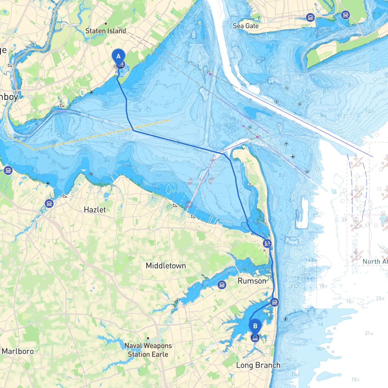
Pilotage Plan from Staten Island, NY to Long Branch, NJ
Overview
Embarking on a boat trip from Staten Island to Long Branch, this route takes you along the scenic shores of New Jersey, providing a mix of urban exploration and tranquil maritime landscapes. This journey will immerse you in a unique blend of natural beauty and coastal culture.
Recommended Boater Profile
This route is well-suited for intermediate to experienced boaters, comfortable navigating in coastal waters. Those familiar with tidal currents and basic navigation will find this trip particularly rewarding.
Route Details
Departure: Staten Island, NY
Starting your journey at Staten Island, you'll want to ensure your vessel is well-prepared for a day on the water. Take time for a safety briefing with your crew to review emergency protocols, navigational techniques, and ensure all life jackets and safety equipment are onboard.
Navigating the Upper New York Bay
As you set off, make your way towards the Upper New York Bay. Pay close attention to the following points as you navigate:
1. Navigational Aids: The Ambrose Channel is a major thoroughfare; follow its buoys carefully, as it is heavily trafficked by commercial vessels. Use your charts and GPS to stay aware of your position.2. Hazards: Stay clear of the shoals around the Verrazzano-Narrows, and watch for ferry traffic in the vicinity of Staten Island.
Point of Interest: Liberty State Park
As you pass the shoreline of New Jersey, schedule a brief stop at Liberty State Park. This historical site offers stunning views of the Statue of Liberty and Ellis Island, providing an excellent backdrop for photos and a chance to stretch your legs on the shore.
Transition into Lower New York Bay
Continuing eastward, you'll transition into Lower New York Bay. Be mindful of tidal currents, especially as you approach the Raritan Bay. The currents here can be strong and can create challenging conditions, so keep your speed in check and remain vigilant.
Sheltering Bays Along the Route
- Raritan Bay: If conditions deteriorate, Raritan Bay offers several sheltered anchors, such as Keyport and South Amboy. It’s an ideal stop to wait for safe weather conditions.
- Atlantic Highlands: Another option for seeking shelter would be Atlantic Highlands, which is well-equipped with facilities and sheltered areas.
Approaching Monmouth County
As you come closer to your destination, Monmouth County offers a stretch of beautiful coastline dotted with marinas and parks. The Shrewsbury River provides a route for those wanting to enjoy the landscapes along the inland waters.
Navigational Restrictions and Considerations
Be aware of various local regulations regarding speed limits in certain areas, especially near beaches or residential areas. The sections near Long Branch are particularly prone to vessel congestion during summer weekends, thus it's wise to maintain a safe operating distance and speed.
Entrance to Long Branch, NJ
As you near Long Branch, be on the lookout for the various buoys and channel markers guiding you into the marina. Pay attention to any live-aboard vessels and moored boats as they tend to clutter up the entrance, particularly in busy times.
Arrival at Long Branch
Congratulations on reaching Long Branch, NJ—this vibrant beach community offers various attractions for both the sailor and their crew. Explore local cuisine, enjoy beach activities, or relax at one of the seaside parks. If time permits, the Long Branch boardwalk is an excellent conclusion to your journey.
Recommended Boating Apps
To ensure smooth navigation, I strongly recommend utilizing:- Savvy Navvy: This app will assist you in plotting a detailed course while providing real-time weather updates and tides.
- Navionics: A great companion for charting your route and tracking navigational markers.
- Windy: Ideal for monitoring weather patterns that may affect your journey, especially changes in wind direction and strength.
Final Thoughts
While the spots along the way may tempt you to linger, safety must always be a priority. Regularly check weather conditions, ensure your navigation equipment is functioning, and stay alert for other boaters as well as coastal traffic. This trip not only promises stunning views and exciting landfalls but also the thrill of confident navigation through New Jersey's coastal waters. Enjoy your voyage!