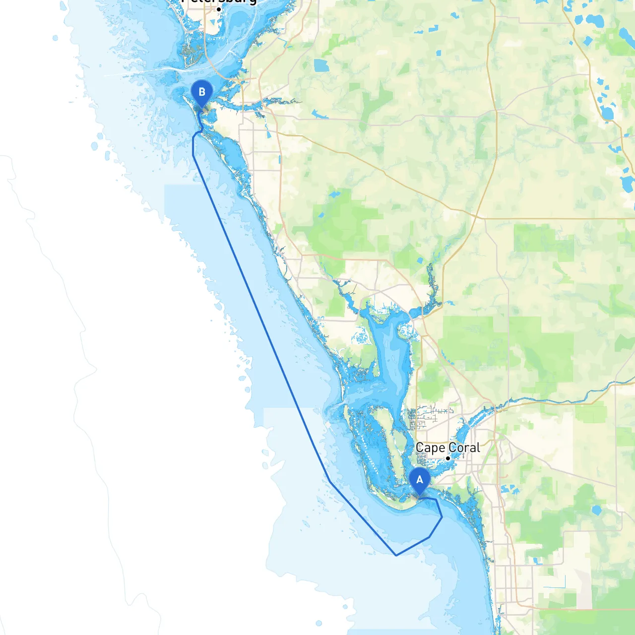
Overview: Setting sail from the enchanting shores of Sanibel Island to the vibrant waters of Bradenton promises a splendid journey through the rich marine tapestry of Florida's Gulf Coast. This route is designed with safety as the highest priority, while still ensuring a delightful experience peppered with unique points of interest and stops for shelter if the weather takes a turn.
1. Departure from Sanibel Island - Starting Point: Sanibel, FL (Coordinates: -82.02817, 26.45367) - Navigation Points: - Cross the San Carlos Bay, keeping a vigilant eye on local boating traffic. - Suggest heading northeast towards Pine Island Sound, an open waterway that offers stunning views.
2. Pine Island Sound - Estimated travel distance of about 8 miles. - Hazards to Note: Shallow waters and occasional shoaling, so maintain a depth sounder for safety and avoid low tide. - Points of Interest: - Cayo Costa State Park: A wonderful stop for swimming, beachcombing, and shelling. Watch for wildlife such as manatees and dolphins in these pristine waters.
3. Matlacha Pass - Continue towards the vibrant waters of Matlacha Pass, approximately 4 miles from Pine Island Sound. - Navigation Aids: - Utilize markers and buoys, especially as you approach the narrow waters of Matlacha. This area can be narrow with local fishermen actively casting. - Shelter Option: Matlacha offers several docks and marinas should weather conditions deteriorate.
4. Charlotte Harbor - Journey east to enter Charlotte Harbor (around 10 miles), a more expansive area that provides ample shelter and beautiful views. - Important Considerations: Be conscious of local wildlife and marine regulations here, as this habitat is protected. - Attractions: - Engage in a quick visit to the community of Punta Gorda for lunch and a stroll along its charming waterfront.
5. Navigating to Sarasota Bay - From Charlotte Harbor, traverse north-east through the Intra-Coastal Waterway (ICW), navigating toward Sarasota Bay. - Key Hazards: Maintain a watch for large boats and ferries operating in this busy waterway. - Vantage Points: - Tangelo Park offers picturesque views for a quick break.
6. Arrival at Bradenton - Final leg to Bradenton is approximately 15 miles from the entry of Sarasota Bay. - Points of Interest: - Anna Maria Island lies just to the west, known for its sandy beaches and quaint shops. A brief stop here could enhance your trip. - End Point: Bradenton, FL (Coordinates: -82.68643, 27.49719)
This route is perfect for recreational boaters, families looking for a mix of adventure and relaxation, and experienced sailors interested in scenic views and wildlife encounters. It presents an opportunity to connect with nature while adhering to safe boating practices. The blend of sheltered bays and lively ports ensures that safety is paramount, yet the journey remains as enchanting as Florida's Gulf Coast is renowned for. Happy cruising!