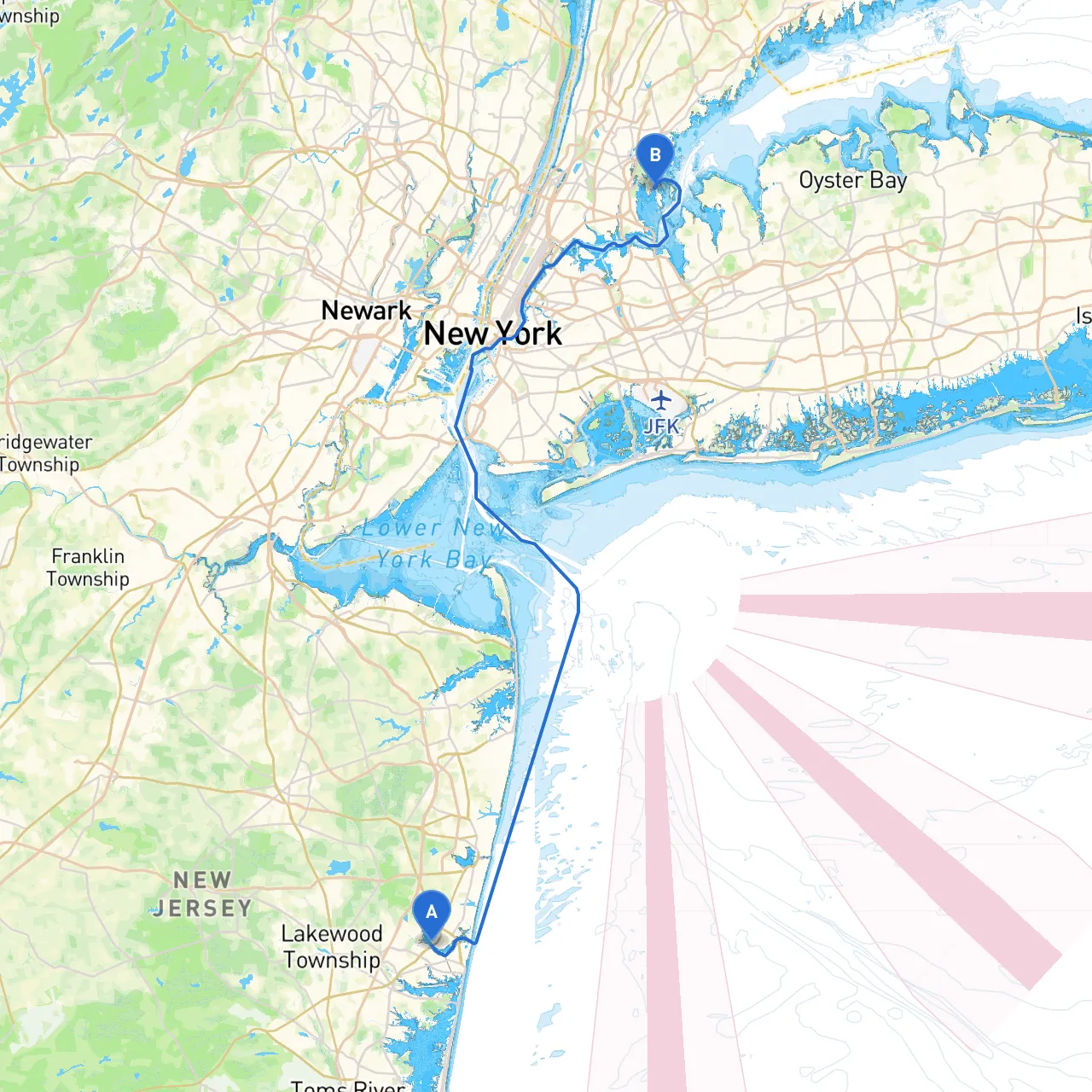
Pilotage Plan: From Point Pleasant, NJ to Bronx, NY
As you set sail from Point Pleasant, New Jersey, the journey to Bronx, New York offers a wonderful blend of picturesque views, interesting navigation challenges, and some great spots for rest and recreation along the way. This cruise suits experienced boaters familiar with coastal navigation, especially considering the need for attention to changing conditions, local regulations, and navigational aids.
Departure: Point Pleasant, NJ
Start from Point Pleasant, located at coordinates -74.0865, 40.099. Before setting off, ensure your vessel is equipped with all necessary safety gear, including life jackets, flares, first-aid kits, and a working VHF radio.
Route Overview
The route primarily takes you through the Manasquan Inlet, down the Barnegat Bay, and eventually up the Hackensack River, navigating through the waterways of New Jersey and New York. The journey spans approximately 45 nautical miles, so plan for a full day of cruising.
Section 1: Point Pleasant to Manasquan Inlet
Hazards: The outgoing tide can create strong currents. Keep a lookout for fishing vessels as you cruise this stretch, and watch for shallow spots.
Points of Interest:
- The Manasquan River: It's a scenic start to your journey; pause here for a snack and explore local dining (e.g., Manasquan River Golf Club).
Navigation Considerations:
- Keep the red and green buoys to your starboard and port, respectively, as you approach the inlet. Listen to VHF ch. 16 for any navigational updates.
Section 2: Manasquan Inlet to Barnegat Bay
As you exit Manasquan Inlet, follow the marked channel into Barnegat Bay, where your adventure truly begins.
Hazards: Be cautious of tidal changes that affect your depth; this area can have sudden shoals.
Shelter Options:
- If the weather becomes inclement, Loveladies or Beach Haven provide excellent shelter facilities.
Points of Interest:
- Barnegat Lighthouse (Old Barney): A great spot for photos and a brief walking tour.
Navigation Tips:
- The bay can be busy with recreational boaters and jet skis. Stay alert and monitor fuel consumption, as the area has fewer refueling points.
Section 3: Barnegat Bay to Raritan Bay
Heading northeast towards Raritan Bay, you’ll experience more expansive waters with beautiful views of Staten Island.
Hazards: Fog can roll in unexpectedly, particularly in the early morning or late afternoon. Maintain a sharp lookout and use radar if available.
Shelter Options:
- If needed, head toward Keyport or Aberdeen for both shelter and refueling options.
Navigation Considerations:
- Watch for significant maritime traffic near the coastline and be aware of ferry crossings.
Section 4: Raritan Bay to New York Harbor
Your approach to New York Harbor is a mariner’s dream, with stunning views of the skyline.
Navigation Aids:
- Keep an eye on the Staten Island Ferry and commercial vessels as they often have the right of way in this busy waterway.
Points of Interest:
- Ellis Island and the Statue of Liberty are prominent landmarks. Allocate some time for anchor and shore visits if your schedule allows.
Local Regulations:
- As you enter the harbor, make sure you’re aware of the security zones around certain landmarks and abide by local navigational regulations, including maintaining speed limits.
Section 5: Navigating Up the Hudson to Bronx
Once you pass the Statue of Liberty, head upriver along the Hudson toward the Bronx.
Hazards: Strong currents can be present, especially during tidal changes; it’s crucial to monitor local tide tables.
Points of Interest:
- The Bronx River and Fordham University; consider beaching at a public dock or marina for exploration.
Final Approach:
- Listen to your VHF, especially when approaching the Spuyten Duyvil, which marks a tidal change point and can have strong currents.
Arrival: Bronx, NY
Your destination in the Bronx opens up a range of possibilities for exploration and enjoyment. Secure your vessel at a local marina, review local regulations, and enjoy your time in this vibrant area.
Recommended Boating Apps
Utilizing technology can enhance your navigation experience. Make sure to have:- Savvy Navvy: Offers detailed charts and route planning.
- Navionics: Great for real-time monitoring and local aids.
- Weather Underground: For timely weather updates.
- MarineTraffic: To monitor vessel traffic and positions.
This journey emphasizes safety, preparation, and a keen awareness of your surroundings, making it superbly fulfilling—but with a couple of quick stops along the way. Enjoy your adventure on the water!