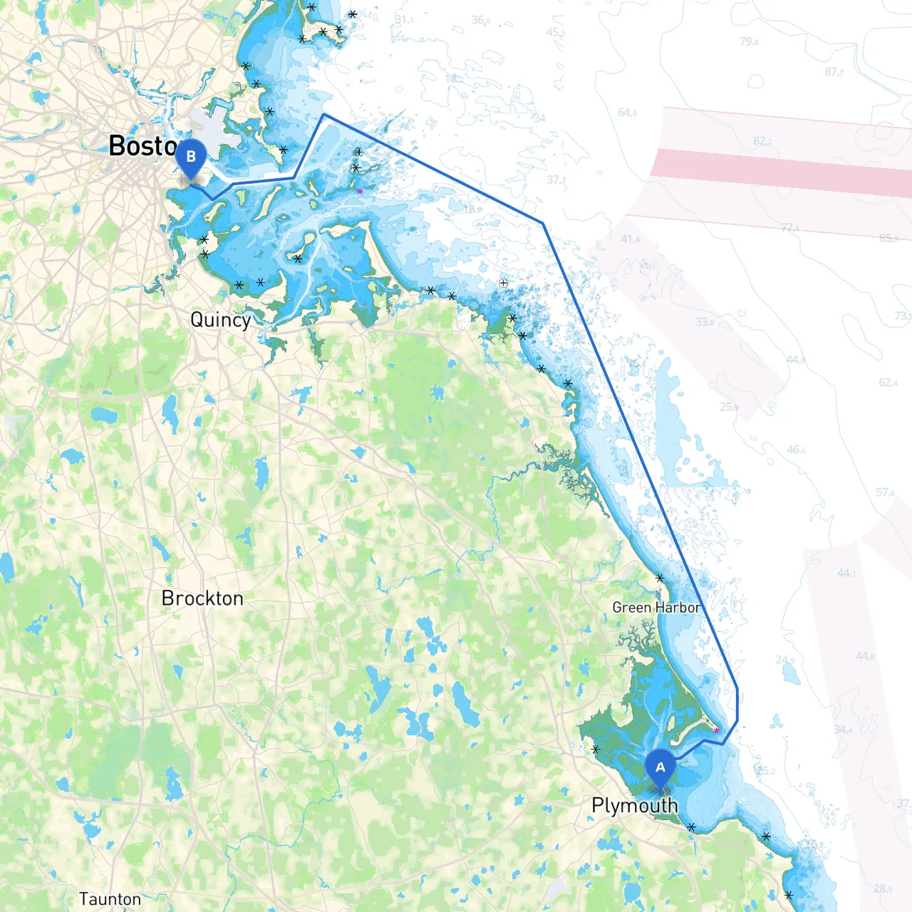
Pilotage Plan: From Plymouth, Massachusetts to South Boston, MA
Overview
This boating trip from Plymouth to South Boston promises a balance of stunning coastal views and vibrant city life, while keeping safety at the forefront. The route spans approximately 30 nautical miles along the beautiful Massachusetts coastline, providing an enriching experience for boaters seeking a mix of tranquility and urban exploration. This journey is suitable for experienced boaters who are comfortable navigating coastal waters and can handle varying weather conditions.
Departure: Plymouth, Massachusetts
Starting your voyage in Plymouth, take the opportunity to enjoy the rich history of this area, known as “America’s Hometown.” Before you set sail, ensure your vessel is well-equipped with sufficient fuel, safety gear, and navigation tools. Check the weather conditions and local tide charts to ensure optimal sailing conditions.
Points of Interest:
- Plymouth Rock: A historic landmark marking the settlement of the Pilgrims.
- Mayflower II: A replica of the original ship that brought the Pilgrims to America.
Shelter Option:
- Plymouth Harbor: In case the weather turns sour, Plymouth Harbor offers a safe anchorage with good amenities.
First Leg: Plymouth Harbor to Duxbury Bay
As you depart Plymouth Harbor, head slightly eastward, keeping an eye on the chart to navigate around the numerous moored vessels. The journey to Duxbury Bay will take you about 4 nautical miles.
Navigational Aids:
- Nantasket Light: Keep this aid to your starboard when you head eastward to stay on course.
Points of Interest:
- Duxbury Beach: Stop for a quick stroll along the beach if conditions allow. The beach is a lovely area to anchor momentarily.
Shelter Option:
- Duxbury Bay: Offers excellent protection from strong winds. A great spot in case conditions worsen.
Second Leg: Duxbury Bay to Marshfield
Departing Duxbury, proceed towards Marshfield, which is about 5 nautical miles further north along the coast. This leg is particularly straightforward, but watch for shoals that can appear unexpectedly.
Navigational Aids:
- Green Can Buoys: Properly navigation will be aided by keeping these buoys to your starboard side.
Points of Interest:
- Brant Rock: A charming spot with opportunities for relaxation and local dining.
Shelter Option:
- Marshfield Harbor: Offers great protection from the open sea. A safe haven when the waves get rough.
Third Leg: Marshfield to Scituate
Next, steer towards Scituate, roughly 5 nautical miles away. This area is known for its historic lighthouse—another excellent photo opportunity. Maintain your course and pay special attention to the local fishing boats that frequent the waters.
Navigational Aids:
- Scituate Lighthouse: A key landmark to guide you into the harbor. Keep it in sight as you approach.
Points of Interest:
- Scituate Harbor: A picturesque harbor perfect for a lunch stop. Local eateries are available with beautiful waterfront views.
Shelter Option:
- Scituate Harbor: Offers reliable protection from the elements, ideal for a planned or unplanned overnight stay.
Final Leg: Scituate to South Boston
The final stretch, about 15 nautical miles, will take you into the bustling waters of South Boston. As you approach, the harbor will become increasingly busy, so maintain a keen awareness of traffic.
Navigational Aids:
- Boston Light: On Little Brewster Island, this visible landmark is crucial as you approach the harbor; it helps to indicate your positioning towards the entrance.
Points of Interest:
- Fort Independence and Castle Island: Ideal for a stop to explore and enjoy some fresh seafood from local vendors.
Arriving in South Boston
Upon arrival in South Boston, be prepared to navigate through a busy harbor. Pay extra attention to commercial traffic and follow the local regulations, particularly concerning speed limits and mooring policies.
Safety Considerations and Recommended Apps
- Ensure your navigation equipment is operational and you have updated nautical charts or apps on hand.
- Monitor weather conditions continuously, especially as you approach the urban landscape where winds can shift unexpectedly.
- Bring a VHF radio for communication; maintain a listening watch for local traffic.
- Recommended boating apps include:
- Savvy Navvy (for detailed charts and nav plots) - Navionics - Windy (for real-time weather updates)
This route offers a wonderful blend of safe harbors, cultural points of interest, and the majestic coastal scenery of Massachusetts. Stay alert, respect boating regulations, and enjoy your adventure from Plymouth to South Boston!