Pilotage Plan: North East, MD to Havre De Grace, MD
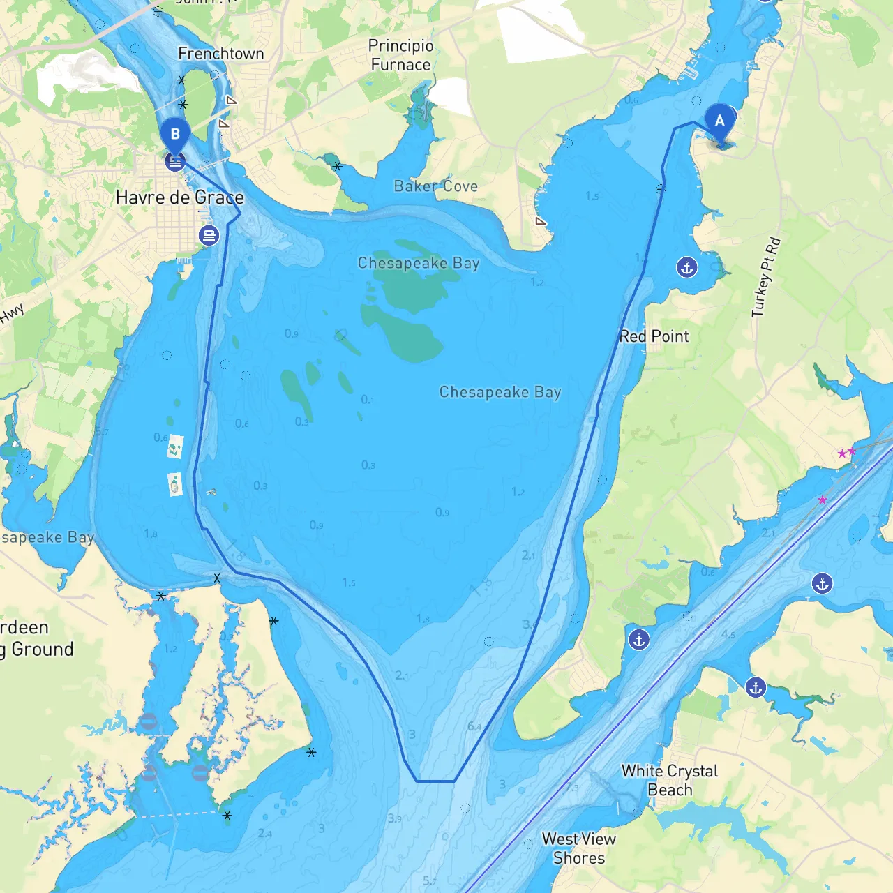
Route Overview:Embarking on a delightful journey from North East, Maryland, to Havre De Grace offers a unique blend of scenic beauty, navigational challenges, and opportunities to explore the rich history of the Chesapeake Bay region. This route is suitable for recreational boaters of various experience levels but is particularly ideal for intermediate to experienced sailors looking to enjoy a day on the water while remaining vigilant about safety.
Start Point: North East, MD
- Coordinates: 39.55805, -75.9627833333
- Before setting out, ensure your vessel is well-equipped and communicate your intended route with a trusted contact. Check the local weather and tides, as these can significantly influence your travel plans.
First Leg: North East to Elk River
- Distance: Approximately 3 nautical miles
- Navigate through the North East River, which is well-marked and relatively wide. This section provides a gentle introduction to your trip. Look out for Green Can “1”, Red N “2” marks as important navigational aids guiding you through the river mouth as you head toward the Elk River.
- Point of Interest: Conowingo Park on the Elk River is a great spot to stretch your legs or have a quick picnic.
- Hazards: Be mindful of shallow waters, especially near the river mouths, and watch for local fishing boats, particularly near the shores.
Second Leg: Elk River to Chesapeake Bay
- Distance: Approximately 6 nautical miles
- After reaching the Elk River, prepare for entry into the Chesapeake Bay. Follow the route to the cut leading into the Bay, marked by buoys. Keep a sharp lookout for other vessels, particularly for fishing boats and sailboats that may be abundant.
- Shelter Spot: If conditions turn unfavorable, you can take shelter in the Elk River where it branches off.
- The current can be stronger here; adjust your course as necessary, especially on outgoing tides. Keep an eye on Red N “4”, which indicates the entry to the Bay.
Third Leg: Chesapeake Bay to Susquehanna River
- Distance: Approximately 5 nautical miles
- Once in open waters, you’re welcomed by the vast Chesapeake Bay; however, this area often sees changes in weather patterns, so be vigilant.
- The waters here can be a bit choppy, particularly with a southeast wind. The Susquehanna River mouth is well-marked.
- Notable Landmark: The impressive Thomas J. Hatem Memorial Bridge becomes visible as you make your approach to Havre De Grace, providing a striking backdrop.
- Navigational Aids: Be alert for range markers as you approach the river mouth and be cautious of shipping traffic.
Final Leg: Havre De Grace
- Distance: Approximately 3 nautical miles
- Enter Havre De Grace, navigating cautiously past commercial shipping channels. Watch for Red N “18” and Green Can “19” markers to guide you into the waterfront area.
- Point of Interest: The Conowingo Dam, a major site for local anglers and wildlife enthusiasts, is visible from the water and is worth a visit on foot.
Safety and Regulations
- Always adhere to speed limits, especially in populated areas like Havre De Grace.
- Maintain a lookout for local laws regarding the protection of wildlife, particularly in areas known for birdwatching or recreation.
- Check for any active fishing or sailing regulations for the regions you are traversing.
- Given the proximity to busy shipping lanes, always keep a safe distance from larger vessels.
Essential Boating Apps
For a seamless navigational experience, consider downloading the following apps:- Savvy Navvy: An excellent app that provides up-to-date charts, weather forecasts, and tidal information.
- Navionics: For detailed charts and mapping.
- Windy: To monitor weather patterns effectively.
This journey from North East to Havre De Grace is a perfect blend of navigation, natural beauty, and potential escapades while emphasizing safety. It’s an adventure waiting to unfold, where every step on the water is an opportunity for discovery! Safe travels!