### Pilotage Plan: Fort Pierce, Florida to Port St. Lucie, Florida#### Overview
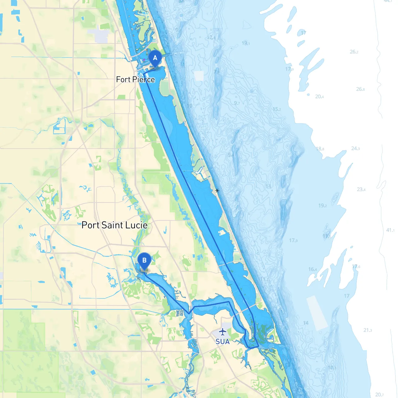
This pilotage plan outlines an enjoyable and safe route for a boating trip from Fort Pierce to Port St. Lucie, a journey of approximately 15 nautical miles along the beautiful Indian River Lagoon. This trip is particularly suitable for cruisers and recreational boaters with moderate experience, looking to explore local attractions and enjoy the scenic beauty.#### Starting Point: Fort Pierce, Florida**Coordinates:** -80.30222, 27.45667Fort Pierce serves as an excellent departure point, equipped with various facilities and a vibrant marina. Before setting out, ensure you check the weather conditions and tides. You can dock at the Fort Pierce City Marina, known for good services and knowledgeable staff.##### Points of Interest Around Fort Pierce:- **A.E. Backus Museum & Gallery**: Dive into local art history, focusing on the works of a noted Florida artist.- **Fort Pierce Inlet State Park**: Make a quick stop at the park for some hiking or wildlife viewing.#### Route Navigation1. **Depart Fort Pierce**: Start your journey by navigating from the marina into the Indian River Lagoon. Make sure to observe the local channel markers as you head south, keeping an eye out for local fishing boats and wildlife. 2. **Navigational Aids**: As you progress, pay attention to the numerous navigational buoys and markers in the Indian River. Prominent markers to note include: - **Buoy '14'**: A key turning point that guides vessels into the navigable waters of the lagoon. - **Channel Markers**: Consistent checking of channel markers and your marine charts will be critical for safe passage.3. **Hazards to Be Aware Of**: - Shallow areas, particularly around the inlet. Operating at a safe speed will help avert surprises. - Local fishing activity may lead to buoys marking fishing zones; give these areas a wide berth.4. **Shelter Points**: If the weather turns unfavorable, consider diverting to: - **North Fork of the St. Lucie River**: This area can offer protection from rough seas and an opportunity to anchor or seek shelter in the winding waterways.#### Notable Landmarks Along the Route- **Manatee Observation**: As you navigate the lagoon, watch for manatees, which are often seen in this area, especially near grass beds.- **Historic Downtown Fort Pierce**: A scenic view from the water, this charming area has a variety of restaurants and shops worth exploring.- **St. Lucie County Aquarium**: Positioned along the route, this aquarium is an educational stop for family outings.#### Final Approach to Port St. LucieAs you close in on Port St. Lucie, continue to adhere to navigational aids and keep monitoring updates on weather conditions. - **Port St. Lucie Inlet**: Recognize this waterway as you prepare to transition into the St. Lucie River. Follow the channel marks closely, especially within this busy harbor area.- **Local Regulations**: Adhere to the no-wake zones to ensure safety and protect the environment, particularly in residential waterfront sections.#### Arrival at Port St. Lucie**Coordinates:** -80.31495, 27.24415Finish your journey celebrating the successful trip with a visit to the local marinas like the River Walk Center or the Port St. Lucie City Marina for facilities, dining, and recreational options. #### Safety Recommendations- **Boating Apps**: Keep track of your route and weather changes using navigation apps, particularly **Savvy Navvy**, which offers essential routing, weather data, and tidal information.- Maintain a well-stocked safety kit including life vests, flares, and a first aid kit. - Always have a float plan filed with a trusted friend or family member before you set out.This picturesque journey not only provides safe navigation and shelter options, but also offers an opportunity to immerse yourself in Florida’s beautiful coastal ecosystem. Happy boating!