Home
 /
New York
 / 

City Island to Perth Amboy by boat

City Island to Perth Amboy

Distance - 40.8 Nm

Avg Speed
5 kts
10 kts
20 kts
30 kts
Time Estimate
8 hr 8 min
4 hr 4 min
2 hr 2 min
1 hr 21 min
City Island to Perth Amboy

City Island to Perth Amboy

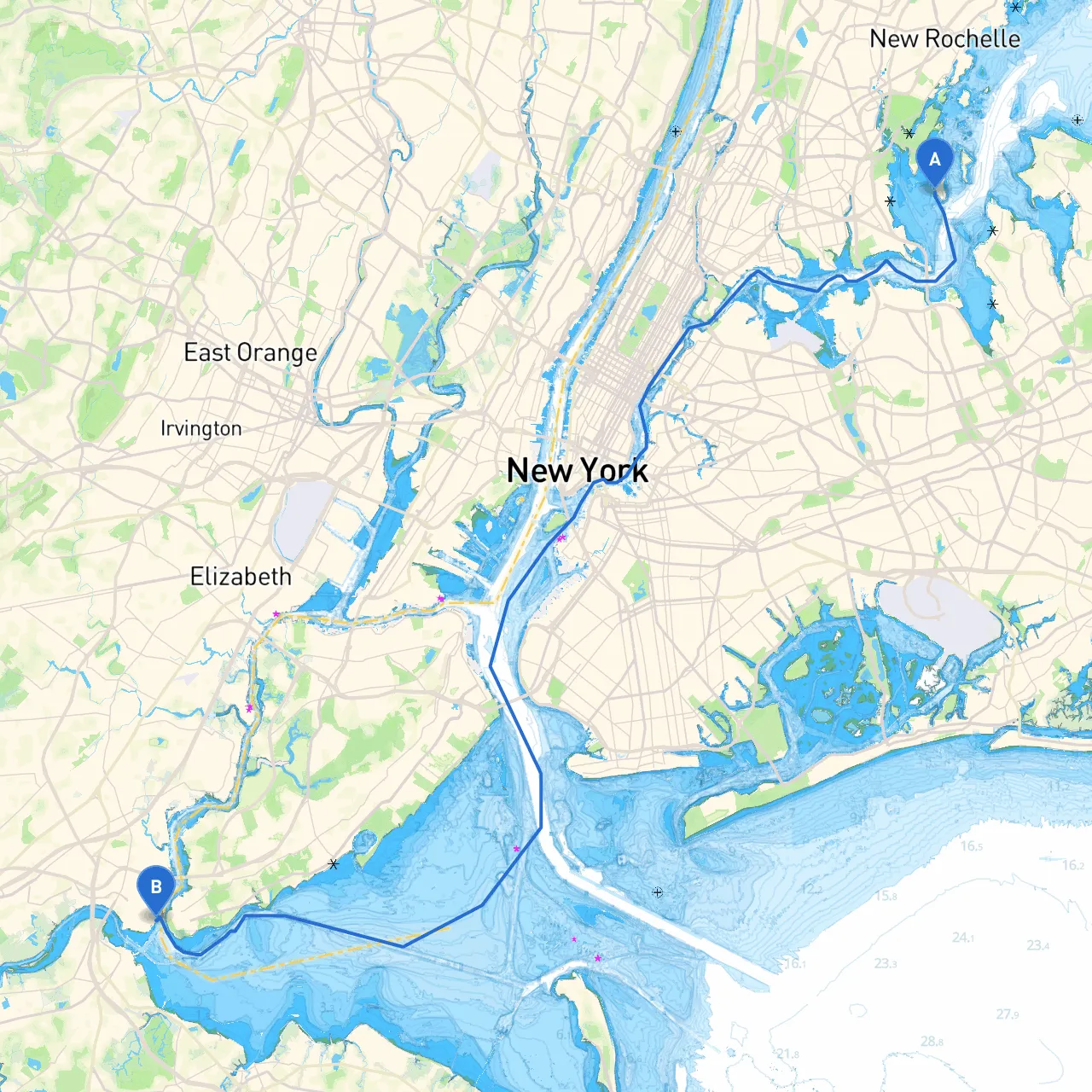
Pilotage Plan from City Island, NY to Perth Amboy, NJ

Route Overview:The journey from City Island, NY, to Perth Amboy, NJ, spans approximately 25 nautical miles and offers a mix of sheltered waters, vibrant urban landscapes, and fascinating historical points of interest. This route is ideal for both experienced and intermediate boaters, offering ample navigation aids, scenic views, and opportunities to avoid any rough weather. Safety is the top priority, and this pilotage plan will equip you with essential information to ensure a smooth voyage.

Section 1: Departure from City Island

As you set off from City Island, conduct a thorough safety check, ensuring all equipment is in good working order, including life jackets, radios, and flares. The first leg of your trip takes you through Long Island Sound, which can be busy with recreational traffic—be vigilant. The best departure point is to sail towards the southern part of the island, exiting through the Eastchester Bay into the Sound.

Navigational Aids:

  • Buoy System: Pay close attention to the buoys marking navigable channels as early positioning here sets the tone for the entire trip.
  • Eastchester Bay: A sheltered spot enabling a quick halt if the weather changes.

Section 2: Long Island Sound

Once you're clear of the Eastchester Bay, enter Long Island Sound, where you can expect a combination of commercial shipping lanes and recreational boaters. The marked channels are well-kept, but keep an eye on your surroundings to maintain safe distances from larger vessels.

Points of Interest:

  • Harts Island: This island can be passed to the west and offers public beaches, though landing may require additional permissions.
  • Execution Rocks Lighthouse: A visible landmark that not only offers a stunning sight but also a historical narrative to the area.

Hazards to Watch:

  • Strong Currents: Currents can be unpredictable in the Sound, especially near the entrances. Monitor tide charts and current tables to anticipate any changes.
  • Rock Formations: These may not always be clearly marked, so maintaining a sharp lookout is essential.

Section 3: Approaching the New Jersey Coast

As you near the western end of the Sound, prepare for the transition towards the Raritan Bay. You will cross through the Throgs Neck Bridge, a key navigation point.

Navigational Aids:

  • Throgs Neck Bridge: This bridge has vertical clearance, so if you are operating a taller vessel, check the clearance height before proceeding.

Shelter Points:

  • Raritan Bay: This bay offers multiple spots for safe anchorage, such as the areas around Keyport and Port Monmouth. Both locations allow ample chances to weather any squall or storm.

Section 4: Entering Perth Amboy

As you make your way into Perth Amboy, keep your eyes peeled for the Raritan River entrance. The local waterfront is bustling with activity, providing a unique backdrop of history and culture.

Points of Interest:

  • Perth Amboy’s Waterfront: Take time to explore local parks, historic buildings, and varied dining options.
  • Amboy Bank Lighthouse: An iconic view and a photograph opportunity that shouldn’t be missed.

Local Regulations:

  • There may be specific speed limits and no-wake zones as you enter the more populated areas. Be sure to observe maritime signage to avoid any fines.
  • Keep updated on local regulations regarding mooring and anchoring, which can frequently change.

Safety Considerations:

  • Always have your marine VHF radio tuned to Channel 16 for emergency assistance.
  • Keep an emergency kit on board and ensure all crew members are aware of safety protocols.
  • Regularly monitor weather updates, particularly the wind direction and speed, as these can change rapidly.

Recommended Apps for Assistance:

  • Savvy Navvy: Ideal for route planning with integrated weather updates.
  • Navionics: Great for detailed charts and local points of interest.
  • MarineTraffic: Useful for tracking other vessels in busy waters.

This itinerary offers both the seasoned mariner and the weekend warrior a safe and exciting journey through some of the most beautiful waters in the region. Whether you’re an experienced cruiser or just starting out, this route is designed to maximize your enjoyment while prioritizing safety and awareness. Prepare, stay safe, and enjoy the adventure!