
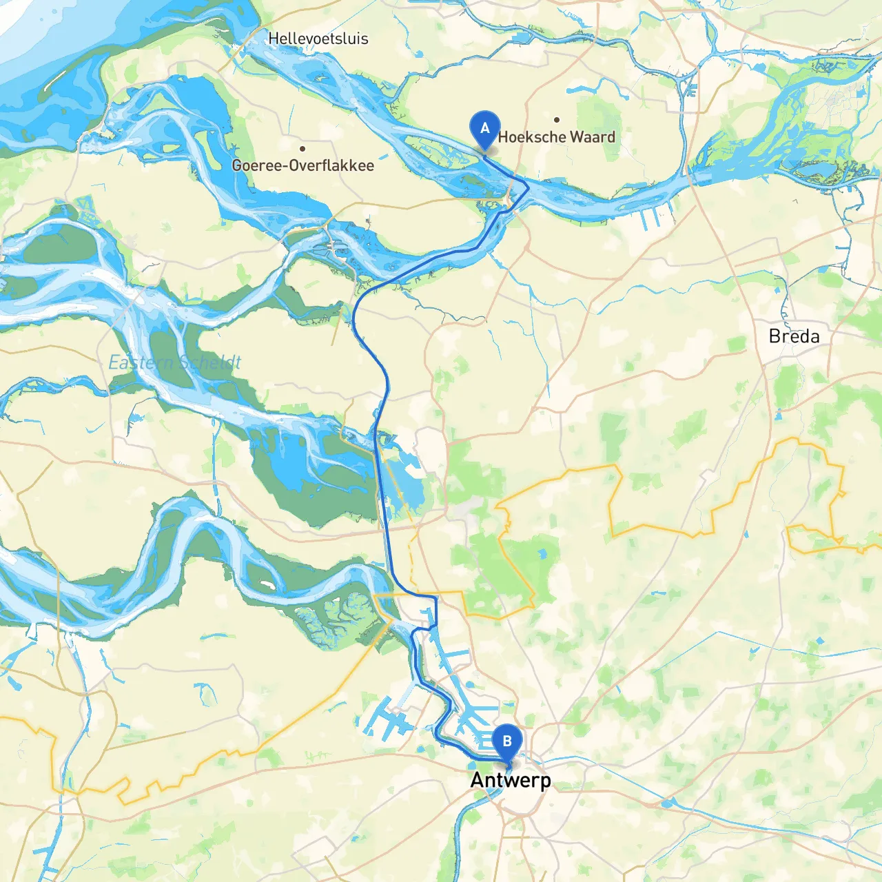
Pilotage Plan: Zuid Beijerland, NL to Antwerpen, BE
Departure: Zuid Beijerland, NL
Your journey begins at Zuid Beijerland, a charming village located at coordinates 4.3659° E, 51.7380° N. Before setting sail, ensure your vessel is adequately equipped with personal flotation devices, safety gear, and navigation tools. The area is primarily composed of low-lying land, so it’s advisable to check the tide times and listen to the local weather forecast to avoid any unexpected changes.
As you depart, take a moment to appreciate the village atmosphere and consider visiting the local market if you have the time. Stocking up on supplies here can be a wise move since you’ll enter more urban areas with limited accessibility to shops.
Section 1: Navigating the Spui River
Your first leg will take you along the Spui River, a narrow waterway but with generally straightforward navigation. Pilots should remain attentive to the channel, as banks are shallow in places. Look for the navigational markers along the river, particularly the green buoys that indicate the safe side of the channel.
Keep in mind the Spui River connects to various smaller waterways; thus, watch for local traffic, including fishing boats and recreational craft. A notable point of interest is the Dutch Waterway, a long stretch revered for its natural beauty and serene views. This is an ideal space for a quick break to soak in the environment or take photos of the picturesque Dutch countryside before continuing your journey.
Section 2: Entering Haringvliet
As you navigate further, you’ll enter Haringvliet, a large estuary famous for its stunning scenery. This area offers several sheltered bays that serve as good spots for refuge should the weather turn inclement. The Haringvlietdam to the west is an engineering marvel, and you may wish to anchor for a moment to admire its structure.
Maintain a lookout for the local wildlife, especially various migratory birds that frequent this area. Check your nautical charts for the best anchorage spots. Following fire and safety regulations is key as some areas have specific mooring practices to protect the marine environment.
Section 3: Down the Nieuwe Waterweg
Continuing your voyage, you’ll transition into the Nieuwe Waterweg, a bustling channel leading towards the port of Rotterdam. Expect commercial traffic here, including large container ships and tankers. Maintain a safe distance and stay vigilant near the shipping lanes.
It’s wise to utilize both a nautical chart and apps like Savvy Navvy, which provide real-time information about marine traffic and tide info, ensuring you are always updated on your surroundings.
This segment provides a remarkable view of the industrial side of the Netherlands, including the famous Euromast and other towering structures of Rotterdam. If time allows, consider a short detour towards the city for an exploratory visit. However, make sure to confirm mooring and anchoring rules as the port is quite busy.
Section 4: Arrival in Antwerp, Belgium
As you navigate towards your destination of Antwerp at coordinates 4.3944° E, 51.2305° N, you will enter the Scheldt River. Watch for the Basin Lillo, a sheltered area where you can safely anchor if conditions worsen. The bustling harbor will greet you as you approach the city, but stay alert for additional navigational hazards, particularly shallow regions at low tide.
Antwerp is rich in history and culture, making it a perfect end point. Consider visiting the Cathedral of Our Lady with its majestic spire or taking a walk along the riverfront promenade. The local culinary scene is vibrant, and a successful trip should always end with an indulgent seafood meal.
Navigation Considerations
Throughout your journey, always adhere to local regulations, including speed limits, particularly in the more congested waterways. Monitor local radio channels for updated information on any maritime traffic issues or warnings. Make sure your VHF radio is operational and ready to communicate emergencies if necessary.
To sum up, this route is ideal for a boater seeking an engaging mix of natural beauty, cultural landmarks, and manageable navigation. Ensure your vessel is properly equipped, respect local guidelines, and keep an eye on changing weather patterns throughout your adventure. Safe travels!