Pilotage Plan: Vero Beach, FL to Ft. Pierce, FL
Overview:Embarking on a boat trip from Vero Beach to Ft. Pierce is a compelling journey perfect for cruising enthusiasts and those looking for a relaxing day on the water. This route stretches approximately 24 nautical miles along the scenic Indian River Lagoon. This stretch is ideal for intermediate boaters who possess basic navigation skills and are diligent about safety.
Pre-Departure Considerations:Before setting off, ensure your vessel complies with safety regulations. Verify that you have adequate life jackets, flares, a functioning VHF radio, and first-aid supplies aboard. Be aware of the current weather and tide conditions, as these can influence your journey.
Route Details:
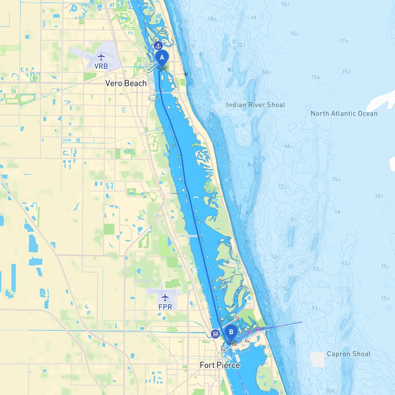
Starting Point: Vero Beach, FL (27.6481° N, -80.3700° W)Your journey begins in Vero Beach, known for its beautiful waterfront and charming atmosphere. Before departure, you may want to explore the local attractions, like the Ocean Drive Historic District or the Vero Beach Museum of Art, if you have time.
Leg 1: Vero Beach to Round IslandSet off southward, keeping an eye on the navigational charts. Watch for the ICW marker
Once you reach Round Island, which lies just south of Vero Beach, it offers a fantastic opportunity to drop anchor. This protected inlet is an excellent place for boaters to seek refuge if the weather changes, and it has a sandy beach ideal for a short respite.
Leg 2: Round Island to Wabasso BridgeContinue your course southward and keep your eyes peeled for the Wabasso Bridge, a notable landmark. As you approach, note the shallow waters by the bridge; ensure your draft allows for safe passage during low tide. There’s a lovely area nearby to tie up and explore nature trails, making for a perfect picnic spot.
Leg 3: Wabasso to Sebastian InletContinue past the Wabasso Bridge and head to the Sebastian Inlet. Here, the inlet opens up into protected waters, making it a desirable stop. This vivid spot attracts both fishermen and recreational boaters. The inlet is heavily monitored, so be aware of local fishermen and abide by the sports fishing regulations in this popular locale.
Leg 4: Sebastian Inlet to Ft. PierceFrom Sebastian Inlet, you’ll navigate towards Ft. Pierce. Stay aligned with the ICW markers as you pass through this charming coastal region. Look for marker
As you move closer to your destination, it’s recommended to keep a keen lookout for local wildlife, especially manatees, who frequent this area. They are often spotted in the waterways but are slow-moving; caution is necessary to avoid any unintended interactions.
Arrival Point: Ft. Pierce, FL (27.4610° N, -80.3168° W)Upon arrival, Ft. Pierce awaits with its vibrant downtown area, marina, and various dining options. The city’s waterfront attracts both fishing and leisure boating enthusiasts, and you may want to take a moment to enjoy the historical sites, like the Ft. Pierce Inlet State Park or the Navy UDT-SEAL Museum.
Hazards and Navigation Considerations:1. Shallow Waters: Pay careful attention to water depth, especially as you approach bridges and inlets, where depths can become unpredictable.2. Navigation Aids: Keep an eye on lanterns and buoys, noting navigational signs. Utilizing GPS systems is highly advisable, along with traditional charts.3. Local Regulations: Be aware of local fishing regulations, especially around Sebastian Inlet, due to its popularity among anglers.4. Weather Changes: The Florida weather can shift quickly. Monitor weather updates frequently, and be prepared to seek shelter at identified bays along your route if necessary.
Safety Recommendations:
With a beautiful array of sights, sheltered bays, and opportunities for exploration along the Indian River, this trip from Vero Beach to Ft. Pierce could just become one of your favorite cruising experiences. Enjoy the peaceful waters, the vibrant marine life, and the charm of Florida’s coastline while prioritizing your safety and preparedness on the water.