
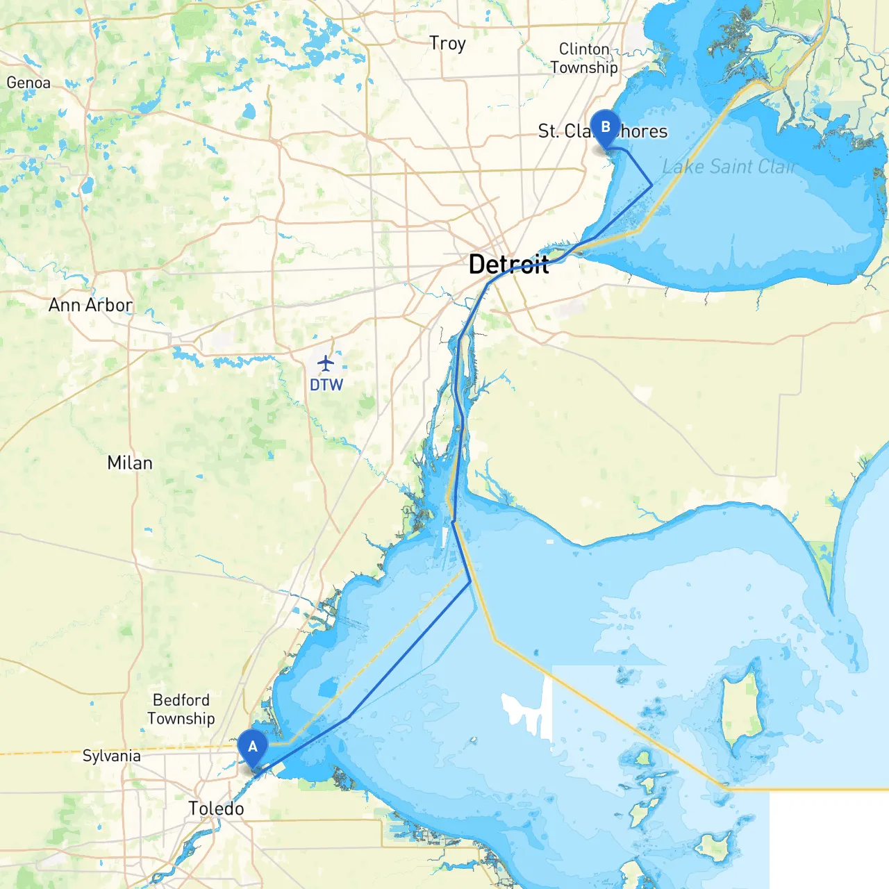
Embarking on this journey from Toledo, Ohio, to St. Clair Shores, Michigan, is an experience that will showcase the beauty of the Great Lakes region while allowing you to navigate through its diverse waterways. The route primarily follows the Maumee River and Lake Erie before threading into the Detroit River and ultimately reaching the shores of St. Clair. This trip suits recreational boaters who seek a mix of scenic views and manageable navigational challenges, making it delightful yet safe for those with moderate experience.
The total distance is approximately 40 nautical miles, and under normal weather conditions, it should take you around 4-6 hours to complete, depending on speed and stops.
1. Maumee Bay State Park: Before venturing into Lake Erie, consider stopping at Maumee Bay State Park for a dose of nature, hiking trails, and serene views. It’s a great spot for a picnic if the weather permits.
2. The Toledo Maritime Museum: A brief detour back into Toledo allows for exploration of maritime history, making for a fun educational stop.
3. Detroit Riverfront: As you approach the Detroit River, don’t miss the vibrant riverfront area where you can explore parks and take in the sights of the cityscape across the water.
4. Grosse Ile: Located midway in your journey, Grosse Ile is a charming island offering picturesque views and plenty of opportunities for a short stop or a leisurely exploration.
1. Leaving Toledo: - Depart the Toledo harbor and head east along the Maumee River. Pay attention to local maritime traffic, as the river can be busy with commercial vessels. - Navigational Aid: Follow the river’s marked channel; be aware of any buoys indicating shallow areas.
2. Entering Lake Erie: - Once you reach Maumee Bay, you'll enter the expanse of Lake Erie. Be cautious of wave action, especially with wind; check the weather before heading out. - Shelter Options: Should conditions deteriorate, consider retreating back to Maumee Bay or seeking refuge in nearby bays like Sandusky Bay.
3. Along Lake Erie: - Navigate northeast towards the Detroit River entrance. The route here is relatively straightforward, marked by navigational aids. Stay aware of changing weather conditions as Lake Erie can be unpredictable.
4. Transitioning to the Detroit River: - As you approach the mouth of the Detroit River, it’s busy with commercial traffic and pleasure craft. - Navigational Aid: Monitor VHF channel 16 for communication and traffic advisories. Remember to keep a safe distance from larger vessels.
5. Heading to St. Clair Shores: - Upon entering the Detroit River, make your way to the point where you should start heading towards St. Clair Shores. This area is marked with several resourceful buoys signaling safe transit pathways. - Caution: Keep an eye out for swift currents in certain sections of the Detroit River, especially near the downriver areas and forks.
6. Final Approach to St. Clair Shores: - As you near St. Clair Shores, the shoreline opens up with recreational marinas. Prepare for docking and make use of local facilities.
This trip from Toledo to St. Clair Shores combines scenic landscapes, opportunities for exploration, and valuable experiences on the water while prioritizing safety. Equip yourself with knowledge of navigational aids, be aware of weather changes, and make use of trusty navigation apps alongside this pilotage plan for a smooth, enjoyable journey on the waters of the Great Lakes. Happy cruising!