Pilotage Plan: South Kingstown, RI to East Providence, RI
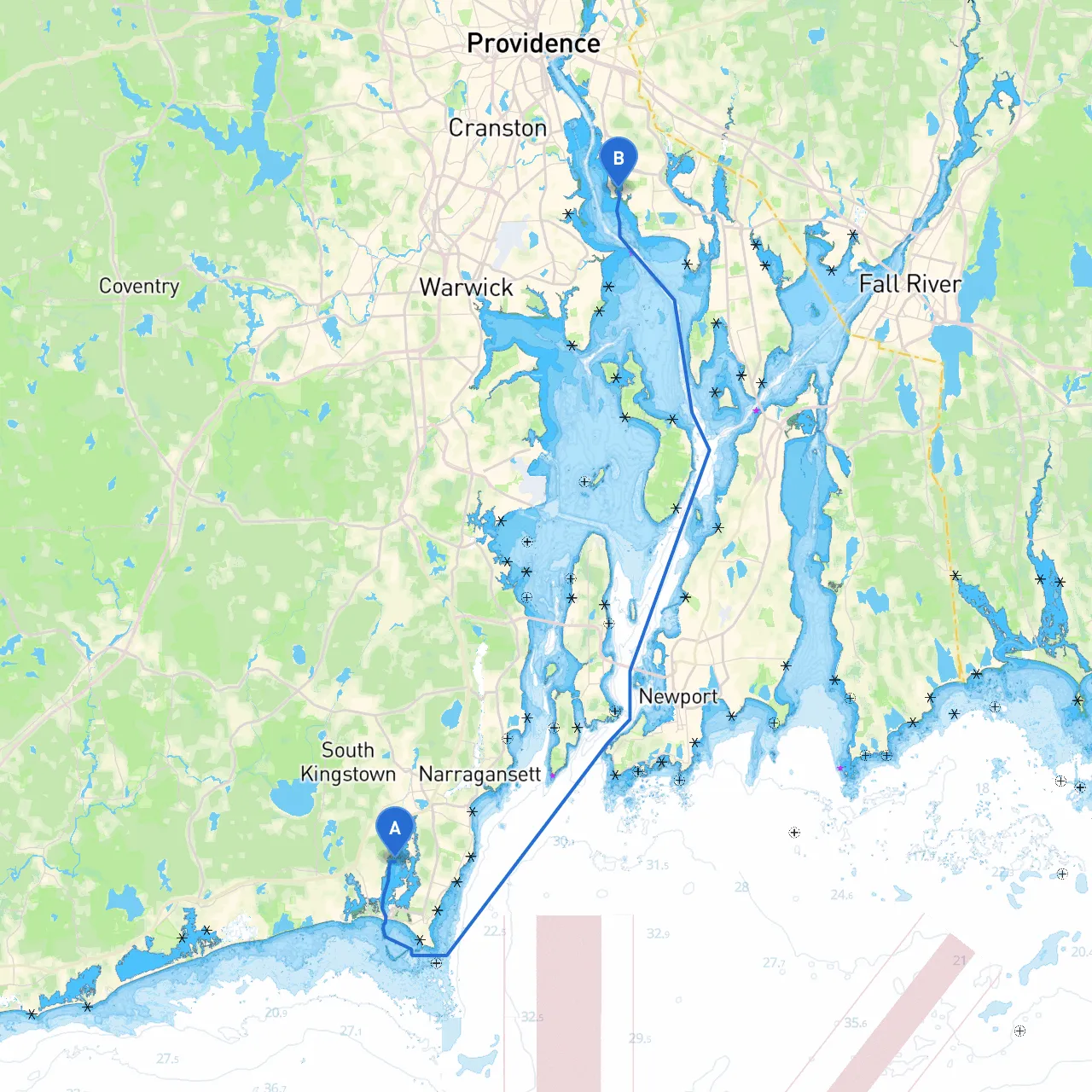
Start Point: South Kingstown, Rhode Island Coordinates: 41.404917, -71.507417 End Point: East Providence, Rhode Island Coordinates: 41.748050, -71.354550
Overview
This cruising route takes you from the charming coastal community of South Kingstown to the vibrant city of East Providence. Spanning approximately 25 nautical miles, this trip caters well to intermediate boaters looking for a combination of stunning views, safe harbors, and a mix of serene and urban cruising environments.
Section 1: Route Planning and Points of Interest
As you depart from South Kingstown, you’ll encounter coastal landscapes dotted with breathtaking homes and lush greenery.
- Attractions: South Kingstown is a fantastic departure point with natural beauties like the nearby Point Judith Lighthouse. Spend some time exploring the quaint shops and cafes in the area before setting sail.
Continuing your journey, you can make your way toward the picturesque Narragansett Bay. This bay provides beautiful scenery and occasional sights of boating events if you’re lucky— or simply interact with other recreational boats.
- Bays for Shelter: If weather conditions change, you will find interest in nearby refuge at Narrow River, located to your northwest. It's an excellent hideaway for shelter from unexpected squalls and provides a serene environment.
Section 2: Navigational Aids and Considerations
Navigating this route requires attention to several critical navigational aids, particularly as you approach
1. Buoys and Markers: Pay close attention to the navigational buoys marking the entrance to the bay. These are colored to help identify safe channels—red to right when returning from sea. You'll primarily want to favor the deep-water channels marked by these buoys.
2. Local Regulations: Be aware of local speed limits in certain areas, especially around busy harbors and near wildlife sanctuaries. Slow down when transiting through areas frequented by fishermen or recreational boaters.
3. Inform the Coast Guard: While not mandatory, it’s courteous and sometimes required in certain regions to inform the local Coast Guard of your passing plan, particularly if entering regions with limited visibility or heavy traffic.
Section 3: The Route and Hazards
From South Kingstown, head out toward the mouth of the
before making a course adjustment toward the north entrance of Narragansett Bay.
Hazards to be aware of:
- Shallow waters: Approach areas like the mouth of the Sakonnet River with caution as the bay can have shifting shallow areas that vary. Keep to marked channels.
- Tidal Currents: Navigate during slack tide if possible, particularly during the changing tides in bridging sections—currents can be strong here.
Section 4: Arrival at East Providence
As you nær Red Rock, you'll enter the scenic Providence River, which leads toward your destination in East Providence. This section is particularly picturesque with views of the city skyline emerging ahead.
- Final Points of Interest: Explore the waterfront at East Providence with accessible marinas and spots to enjoy local cuisine. The area around the Seekonk River is a delightful exploration for souvenir shopping or quick stops for local food.
Once docked, ensure to confirm the nearest services such as fuel stations, repair services, or even marine supply stores.
Recommended Apps for Safe Navigation
For a smooth sailing experience, keep useful navigation apps on hand. They can bolster your situational awareness and provide additional route planning insight:- Savvy Navvy: This app will be invaluable for plotting routes and gives comprehensive charts and navigational capabilities.
- Navionics: Great for smart charts and community updates on conditions.
- Windy: To keep an eye on weather conditions while underway.
This pilotage plan offers a splendid balance of safety and scenic beauty in Rhode Island’s waterways. Enjoy your journey from South Kingstown to East Providence, taking full advantage of the vistas, shelters, and recreational opportunities that lie ahead! Safe boating!