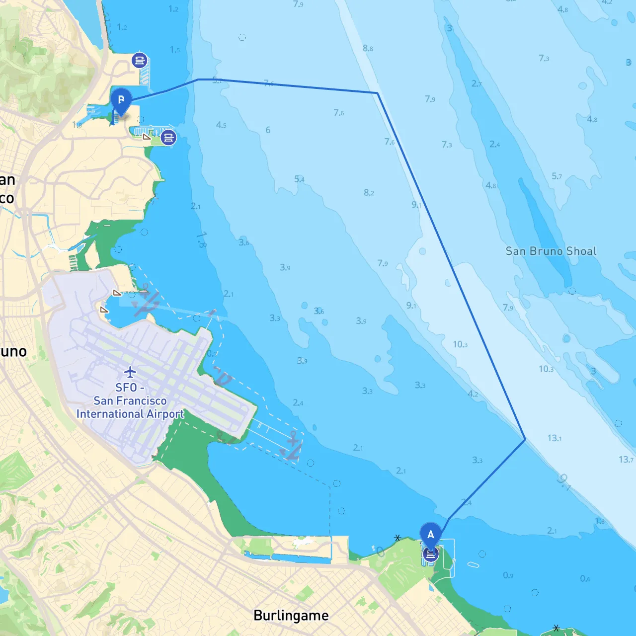
Route Overview:Embarking from San Mateo, CA, unfold a scenic yet navigationally rich journey to South San Francisco, CA. This route, ideal for experienced cruisers and novice boaters alike, steers through an intricate network of waterways, with plenty of landmarks, sheltered bays, and navigational aids that ensure a safe trip even when the weather turns.
Starting Point: San Mateo, CA Coordinates: Latitude 37.588918, Longitude -122.316070
Departure Considerations:
Navigating to South San Francisco:As you cruise out of San Mateo, wind your way towards the San Francisco Bay’s main channel. Key navigational aids will guide your journey:
1. Navigational Aids: - Follow the channel markers leading towards the Bay’s main shipping lanes, paying attention to the flashing lights that indicate deeper waters. - Monitor your chart plotter or app, keeping an eye on your position relative to buoys and beacons along the way.
2. Shelter Points: - Seal Slough: A calm inlet that provides excellent shelter from rough waters should conditions change unexpectedly. - Coyote Point: This area boasts scenic views and a recreational park, perfect for a short break or fishing. - Mare Island Strait: An alternative route if you need to divert due to poor weather conditions or traffic in the main channel.
3. Points of Interest: - As you traverse the bay, keep your senses tuned to the rich maritime activity. The historic Coyote Point Marina is bustling and lively, with opportunities for refueling and refreshments. - The iconic San Mateo Bridge is a marvelous engineering landmark; capturing its view from the water is a memorable photo opportunity.
As you near South San Francisco, continue to navigate while heeding these critical safety tips:
1. Channel Traffic: Be mindful of larger vessels entering or leaving the busy port of San Francisco. Maintain situational awareness and operate your vessel at a safe speed—this is crucial in crowded waters.
2. Regulatory Compliance: Recognize the importance of adhering to local navigational regulations. Pay particular attention to any no-wake zones and speed limits, especially near residential areas and harbors.
3. Final Destination: South San Francisco, CA Coordinates: Latitude 37.665741, Longitude -122.385120
Upon arrival, check local harbor facilities for mooring options, fuel stations, and amenities. The South San Francisco Marina provides a welcoming environment, with access to restaurants and local attractions should you wish to explore further.
This cruising route from San Mateo to South San Francisco offers a blend of safety, adventure, and picturesque views, making it suitable for boaters of varying expertise. Stay vigilant, respect the navigational aids and regulations, and enjoy the journey across one of California’s dynamic waterways. Safe travels!