Pilotage Plan for a Boat Trip from Portsmouth, Rhode Island, USA to Harwich, MA, USA
Trip Overview This trip is designed for boater enthusiasts looking to explore the tranquil yet stunning waters of the northern coast of the Atlantic Ocean. It encompasses a journey filled with fascinating coastal features, charming towns, and ample opportunities for shelter and respite should weather conditions take a turn for the worse. This route is particularly suitable for experienced cruisers and intermediate boaters, as it provides navigation challenges while remaining enjoyable and picturesque.
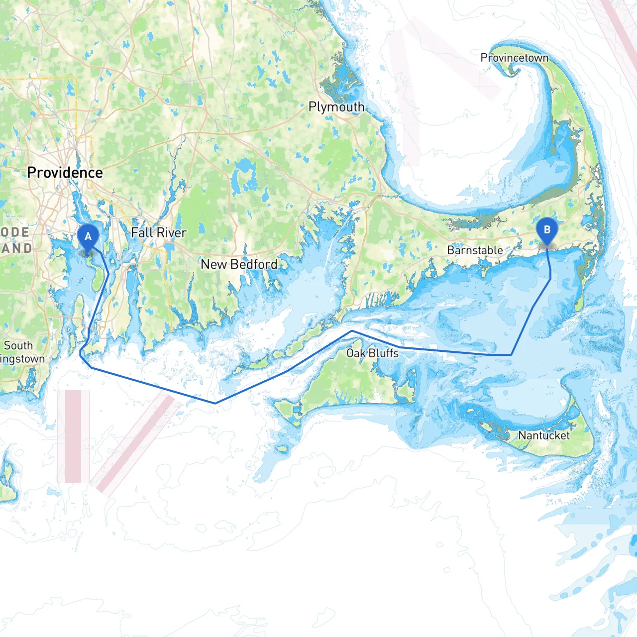
Route Description Your journey will begin in Portsmouth, where the vibrant bay and historic harbor set the stage for your adventure. As you navigate eastward, you’ll make your way through Narragansett Bay before heading north towards Cape Cod. Keep in mind that the charted route may include navigational hazards, requiring careful plotting and attention to weather patterns.
Key Sections of the Route:
1. Portsmouth to Narragansett Bay (5 nautical miles) Leave the harbor at Portsmouth, aligning your course towards the East Passage of Narragansett Bay. You will encounter Castle Hill Lighthouse to your left, an iconic landmark and a perfect photo opportunity. Stay clear of the underwater hazards near the mouth of the Bay; pay attention to the beacons that mark these areas.
2. Navigating Narragansett Bay (20 nautical miles) Sailing through the bay provides a multitude of sheltered spots. A notable stopover is Jamestown Harbor, perfect for sheltering from inclement weather. Jamestown offers various amenities for boaters including fueling services and dining options. As you proceed towards the northern end of the Bay, be mindful of the “No Wake” zones around residential areas to ensure safety and compliance with local regulations.
3. East Passage to Block Island Sound (10 nautical miles) Once you exit Narragansett Bay, head towards Block Island Sound with a vigilant eye on the weather. Be aware that this stretch can present a more open sea aspect, and swells may occur. The prominent Point Judith Lighthouse will guide you along this leg of your journey. If conditions become unmanageable, consider taking shelter in Point Judith Pond, where calm waters await.
4. Arriving at Cape Cod Canal (12 nautical miles) As you approach the entrance of the Cape Cod Canal, the approach offers breathtaking scenery. The canal is well-marked with navigational buoys; however, take care to avoid the swift currents especially near the entrance. Entering the canal grants you access to various recreational opportunities, such as fishing or exploring local beaches. The canal serves as a safe passageway leading to Cape Cod Bay.
5. Cape Cod Bay to Harwich (15 nautical miles) Continuing your journey through Cape Cod Bay, keep an eye out for fishing boats and recreational vessels as you navigate towards Harwich. The waters are usually calm but adhere to any local regulations concerning protected areas and boating speed limits. As you near the town of Harwich, the enchanting shoreline is dotted with quaint beaches and summer homes, providing a picturesque setting to complete your voyage.
Areas of Shelter Throughout your excursion, you’ll encounter ample opportunities for safe anchorage. Notable spots include:
Utilizing these shelters will ensure that you have safe havens while waiting out poor weather or enjoying a leisurely break.
Navigational Aids and Regulations Boaters should remain vigilant with their charts, especially when passing through busy areas like the Cape Cod Canal. Familiarize yourself with the local navigational aids, including:
Additionally, be sure to check local boating regulations, particularly in protected wildlife areas along Cape Cod, to respect the environment and preserve the beauty you’re out to enjoy.
Useful Apps For navigation assistance and real-time data, consider downloading these boating apps:
These tools will enhance your trip planning and execution, giving you accurate weather forecasts and vital navigation support.
Conclusion This pilotage plan offers a blend of safety, navigational skill, and the opportunity to enjoy the charming coastal environment of southern New England. While the route demands attention and respect for local conditions, the picturesque beauty and intriguing landmarks provide an unforgettable boating experience. Happy cruising!