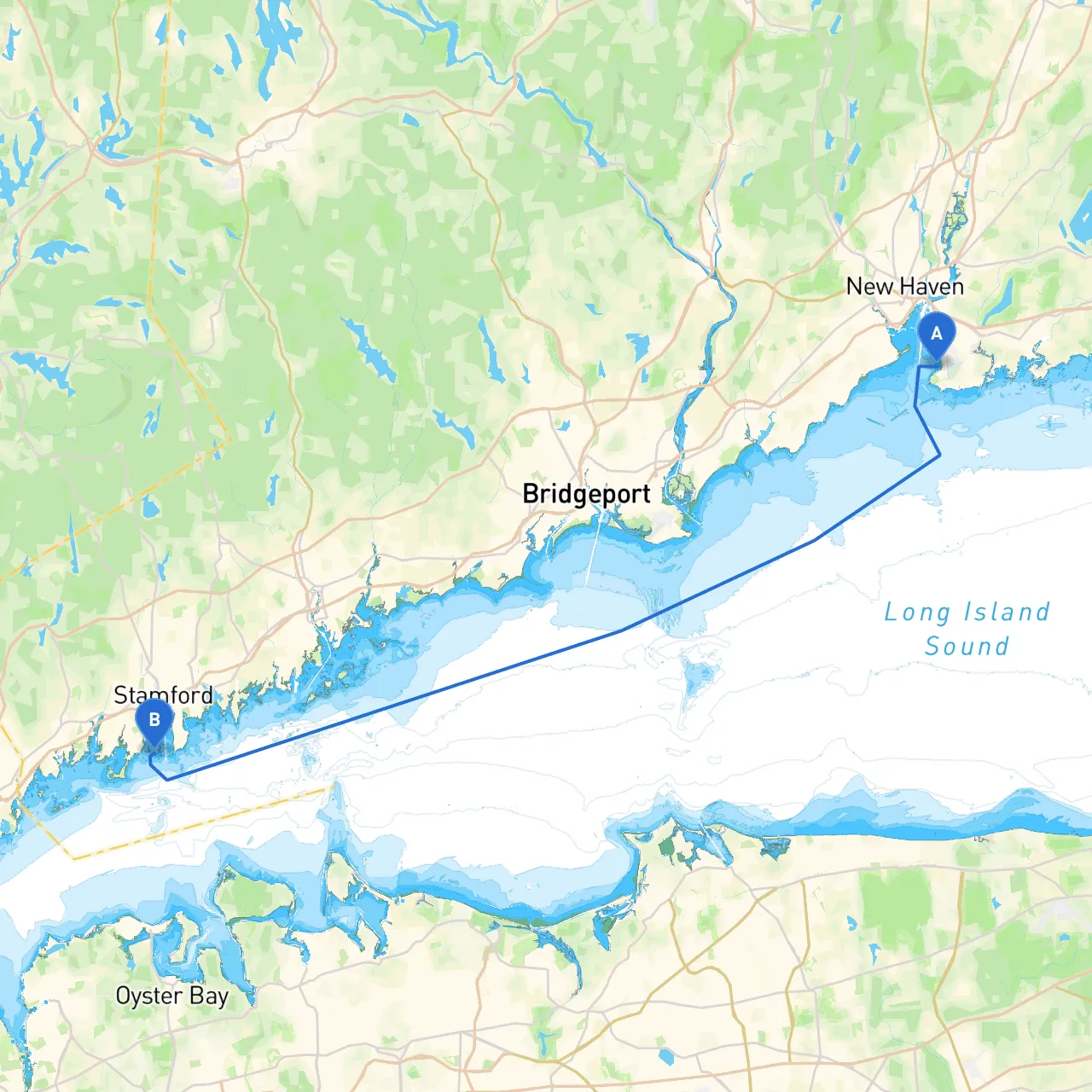
Pilotage Plan from New Haven, Connecticut to Stamford, Connecticut
Overview
Embarking on a boat trip from New Haven to Stamford is an incredible opportunity to explore the beautiful waterways of Connecticut’s coastline while having the opportunity to experience splendid views, wildlife, and historical landmarks. This trip is suitable for intermediate to experienced boaters who are comfortable navigating varied waters and are prepared for changing weather conditions.
Starting Point: New Haven, Connecticut
Longitude -72.8986 | Latitude 41.2582
Departure Notes:
- Before setting sail, ensure your vessel is well-stocked with necessities including safety equipment, navigation charts, and provisions.
- Check local weather forecasts and be aware of current conditions—know the risks of sudden storms in this region.
- New Haven's harbor is generally protected, but you should monitor conditions closely before departure.
Notable Points of Interest en Route
: As you head out, East Haven will be visible to the west, where you can explore local beaches or enjoy a meal at one of the bay-side restaurants.
2. Branford and Branford River: After navigating out of New Haven Harbor, a slight detour into the Branford River can provide a peaceful stopover with scenic views, picnic spots, and a taste of local culture. It’s also a good location for shelter if the weather turns.
3. Quinnipiac River: This charming river is slightly off your direct route but offers another great harbor with the opportunity for sightseeing and a relaxing environment.
4. Hammonasset Beach State Park: Featuring stunning beaches and nature trails, this is an excellent stop for relaxation. Be aware that it can get crowded on weekends, so plan your timing accordingly.
Route Overview
As you leave New Haven, head east into the Long Island Sound. The water can get busy with recreational and commercial boat traffic, so maintain a watchful eye on channel markers and other vessels.
- Navigational Aids: Pay close attention to buoys marking the shipping lanes and shallows. Major navigational aids along the route include:
-
– A critical point signaling your departure. -
– Marking the entrance to the drainage channel for Branford River.
Important Navigational Considerations
- Maintain a speed that balances the waves to maximize comfort and safety.
- Watch for current and tide changes, especially as you approach bridges or rivers.
- Be familiar with local maritime regulations, including vessel speed limits in specific areas and areas designated for fishing or no-wake zones.
Shelter Points
- Hammonasset Beach State Park: A lovely shelter in case conditions worsen. There are ample facilities and a protected harbor.
- Branford River: Allows for anchoring in calm waters if you encounter bad weather.
Destination: Stamford, Connecticut
Longitude -73.5465 | Latitude 41.0172
Arrival Notes
As you approach Stamford, you will navigate past the bustling commercial harbor. Ensure to stay in marked channels to avoid shallow waters and follow all local traffic rules. Stamford has a vibrant marina scene with facilities for refueling and restocking supplies.
- Considerations at Stamford: The marina offers various amenities for boaters. Make sure to familiarize yourself with docking procedures to avoid overcrowding and ensure safety as you berth.
Boating Apps
For your journey, having navigational apps can serve as essential tools for a smooth trip. Consider the following:- Savvy Navvy: Perfect for route planning and real-time navigation.
- Navionics: Gives detailed charts and helps plan your course effectively.
- Weather Apps: Keep an eye on the latest weather conditions.
This trip from New Haven to Stamford is not only a chance to navigate Connecticut’s beautiful waters but also an opportunity to connect with nature and local culture at great stops along the way. With safety as a priority, this plan helps ensure an enjoyable and memorable boating experience.