Pilotage Plan: Ladner, BC, CA to Point Roberts, WA, US
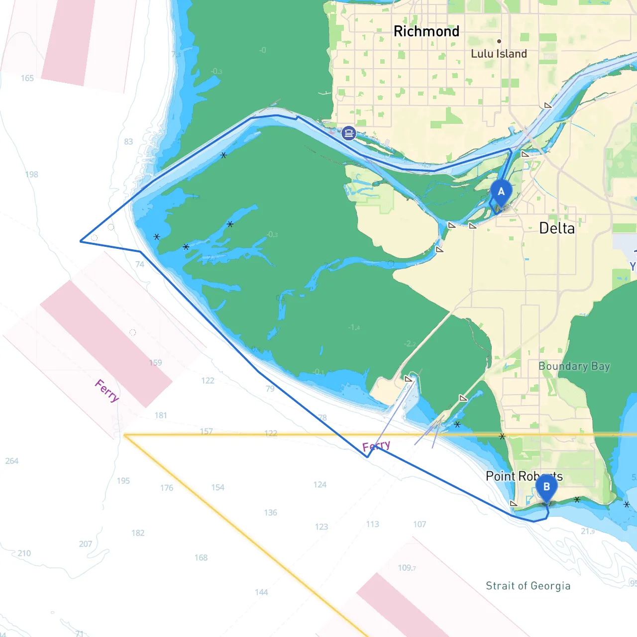
Departure: Ladner, BC, CAAs you prepare to embark from Ladner, a charming and historic fishing village, ensure your boat is equipped for the journey. The coordinates for your departure are approximately 49.0914° N, 123.0918° W. This area has good access to fuel and provisions, so ensure your supplies are stocked before setting off.
Route OverviewThe journey to Point Roberts is approximately 14 nautical miles northwest through scenic waterways, including tidal channels. While relatively short, this trip is rich in natural beauty and offers an excellent experience for coastal cruising. The route efficiently utilizes the scenic waterways that reflect the magnificence of British Columbia's coast.
After departing from Ladner, head south through the Boundary Bay area. The tidal streams here are significant, so be mindful of the tides when planning your departure. Maintain a lookout for the various local species of birds and, with luck, the occasional marine mammal.
As you navigate, keep in mind the small island chain leading south towards Tsawwassen. The navigation aids here, especially the Tsawwassen Light, will help guide your course along open waters.
If you encounter inclement weather or need to anchor, consider seeking refuge in the North Arm of the Fraser River or even heading to Tsawwassen if time permits. Tsawwassen is a larger marina with various amenities, including restaurants and provisions, making it a friendly stop for travelers.
As you approach Point Roberts, watch for navigational markers indicating the border between Canada and the US. This stretch of water is primarily used for recreational boating and has no significant hazards; however, be cautious of fishing boats in the area. Expect to encounter various marine traffic, as this is a popular area for local boaters.
Keep an eye on the prominent Point Roberts Marina, a notable landmark on your approach, and ensure you have your customs declaration ready, as this is a border crossing. Important navigational aids include buoys marking the entrance into the Point Roberts harbor.
Once you arrive at Point Roberts, indulge in the diverse activities this unique landmass offers. The Point Roberts Marina is a great starting point for inland exploration. The area boasts serene parks like Lighthouse Park and scenic beaches for walking and picnics. If you enjoy a round of golf, the beachfront golf course provides stunning views, making for a delightful afternoon.
This trip is perfect for seasoned coastal cruisers looking for a short yet enriching journey. The combination of picturesque landmarks, opportunities for wildlife sightings, and safe harbor options make this an accessible route for boaters of all experience levels. Enjoy the journey, respect the waters, and happy sailing!