Home
 /
 / 

Jersey City to Brooklyn by boat

Jersey City to Brooklyn

Distance - 23.7 Nm

Avg Speed
5 kts
10 kts
20 kts
30 kts
Time Estimate
4 hr 43 min
2 hr 21 min
1 hr 10 min
0 hr 47 min
Jersey City to Brooklyn

Jersey City to Brooklyn

### Pilotage Plan: Jersey City, NJ to Brooklyn, NY**
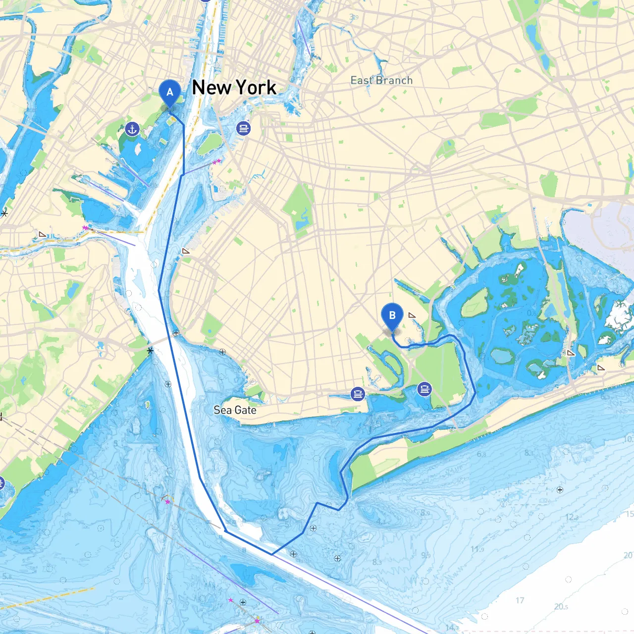
Starting Point: Jersey City, New Jersey, United States** **Ending Point: Brooklyn, New York, United States**---#### OverviewThis route from Jersey City to Brooklyn offers an exciting and picturesque journey through some of New York Harbor's most dynamic waters. As you navigate this busy maritime environment, safety and awareness are paramount. This trip is well-suited for experienced boaters who are comfortable with urban navigation, varying water traffic, and potential weather changes.---#### Points of Interest and Notable Hazards1. **Liberty State Park**: Just out of Jersey City, the park offers stunning views of the Statue of Liberty. It’s a delightful spot to stop and take pictures, while also being equipped with facilities should you need them.2. **Lower New York Bay**: As you head southeast, preparing to cross the bay is crucial. Be cautious of larger commercial vessels and the potential for sudden weather shifts. This area can get choppy, particularly during prevailing winds.3. **Hoboken**: Home to waterfront parks, Hoboken offers another perfect stop for taking a break. Consider anchoring in the Hudson River prior to the city, allowing you to explore the local eateries and bars.
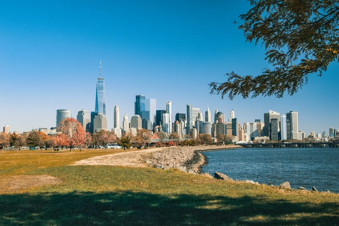
4. **Battery Park**: As you approach Battery Park, you're entering one of the busiest areas of the port. The Battery is a great view stop, but heed the heavy commercial traffic.5. **Brooklyn Bridge and Dumbo**: One of the highlights as you enter Brooklyn is the iconic Brooklyn Bridge, which offers splendid photo opportunities. Nearby Dumbo is a great area for experiencing local culture, shops, and eateries.---#### Navigation and Safety Considerations- **Tides and Currents**: Be aware of the tidal changes, especially in the Upper New York Bay. The tidal current can run strong, impacting your boat's speed and course. Consult tidal charts to plan your departure and arrival to optimize your travel time.- **Maritime Traffic**: This route crosses a busy shipping lane near the Verrazzano-Narrows Bridge. Maintain a vigilant lookout for ferries, cargo ships, and recreational vessels. VHF radio monitoring is essential here; tune into Channel 13 for intra-harbor communications.- **Navigational Aids**: Familiarize yourself with the lighthouses and buoys along the route. Key aids include: - **Ellis Island Light**: Marking your approach near Liberty Island. - **The Sandy Hook Light**: Serving as an important landmark for orientation. - **Weather Monitoring**: The waters can change quickly. Utilize weather apps, ensuring that you have access to real-time conditions. Also, don't overlook the importance of having reliable equipment on board that can give you timely updates regarding storms or high winds.- **Local Regulations**: Always adhere to speed limits in no-wake zones, particularly near docks and marinas. Be aware that certain areas may have restrictions or require permission for anchoring or mooring.---#### Suggested Shelter Options- **Hoboken Marina**: As you make your way toward Brooklyn, Hoboken Marina provides a secure place to dock if conditions worsen. It’s also a lovely spot to unwind.- **Brooklyn's Sheepshead Bay**: A further option if conditions deteriorate significantly. Here, you can find facilities and fishermen’s eateries, giving you a chance to sit back while the weather passes.---#### Ideal Boater TypeThis route suits skilled boaters who are confident navigating near heavy traffic and urban settings. Intermediate sailors familiar with tidal waters will also enjoy the journey, although some may find the arrangements complex. The experience is both rewarding with scenic views and steeped in the vibrant history of New York.---#### Recommended AppsFor added peace of mind and efficient planning, consider downloading the following boating apps:- **Savvy Navvy**: This app combines charts with a route planner and weather forecasting, allowing you to navigate safely.- **Windy**: Provides detailed wind and weather maps.- **Navionics**: Offers advanced chart plotting capabilities.---As you set off on your journey from Jersey City to Brooklyn, ensure that your vessel is seaworthy and stocked for safety. The blend of iconic landmarks with the brimming activity around you will make this a trip to remember while adhering to nautical safety principles. Enjoy the waters!

More routes from Jersey City to Brooklyn

No items found.