Pilotage Plan: Isle of Palms, SC to Mount Pleasant, SC
Overview of the Route
Embarking on a boat journey from Isle of Palms to Mount Pleasant offers a delightful blend of tranquil waters, scenic views, and an assortment of navigation challenges. This route is ideal for intermediate-level boaters who have a grasp of basic navigation yet seek the thrills of coastal cruising.
Departure from Isle of Palms
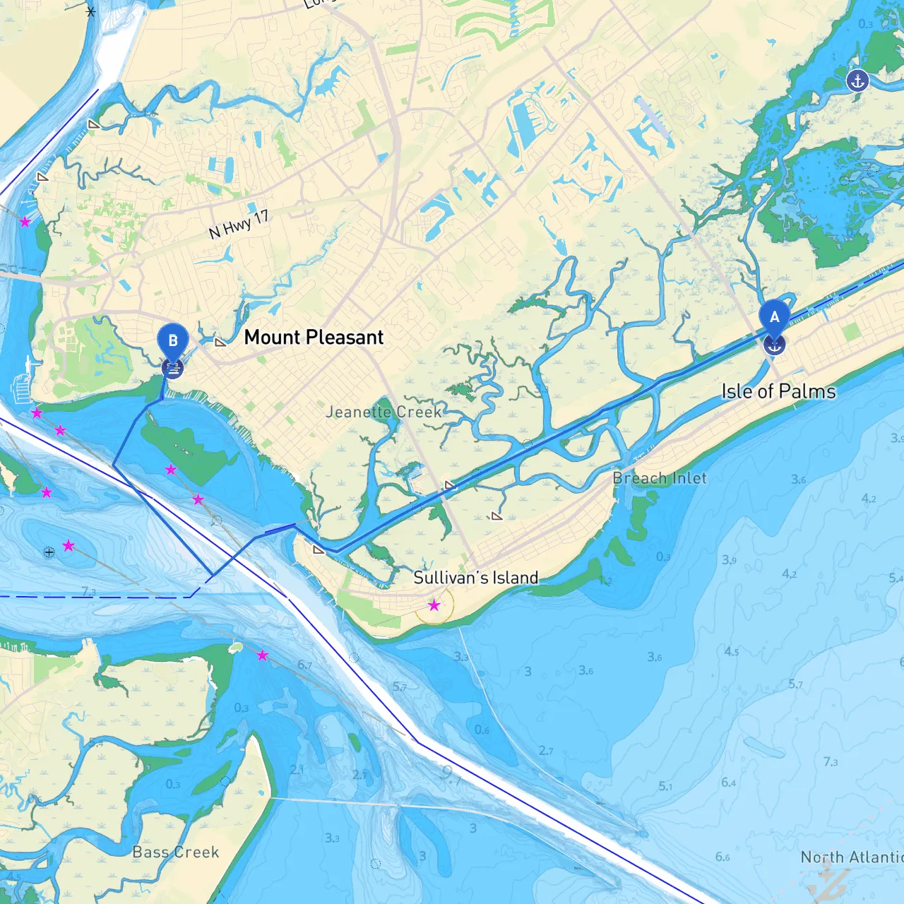
Start your voyage at the Isle of Palms Marina. Before setting off, be sure to check the weather forecast and any tide tables, particularly since tidal variations can impact vessel draft and efficiency. Departing from the marina, follow the channel markers to safely navigate through the waterways.
Notable Waypoints
1. Isle of Palms Inlet: As you exit into the Atlantic, pay close attention to the shifting sands in the area. The currents can be tricky, particularly during outgoing tides. It’s advisable to keep within the buoyed channels as you make your way towards the Intracoastal Waterway (ICW).
2. Waterway Junction: After navigating through the inlet, you will join the Intracoastal Waterway. Here, the markers are exceptionally clear, and you’ll have a chance to enjoy the scenic marshlands that characterize this section of the coast.
3. Shem Creek: This is a wonderful detour if you wish to take a break. The creek is picturesque and is flanked by numerous waterfront restaurants and shops. Keep an eye out for the fishing boats and paddleboards as they navigate this vibrant area.
Shelters and Bays
- Shem Creek: As previously mentioned, Shem Creek not only offers dining options but also serves as a great shelter spot in case of sudden changes in weather.
- Charleston Harbor: Should you find yourself needing to take shelter, Charleston Harbor is a short detour to the south. Its expansive waters and myriad of anchorage spots make it ideal for weather conditions that shift quickly.
Navigational Considerations
- Daybeacons and Buoys: Familiarize yourself with the local navigation aids while cruising along the ICW. Key markers include “G” and “R” buoys that help delineate the channel. Pay particular attention to lighted markers, especially during twilight hours.
- Drawbridges: As you near Mount Pleasant, watch for the Ben Sawyer Bridge. This bridge has restricted opening times, and it is essential to check the schedule prior to your trip. Timing your passage accordingly can save significant delays.
Local Points of Interest
- Fort Sumter National Monument: If you're up for an adventure, consider making a brief stop at the historic Fort Sumter, located on an island at the entrance to Charleston Harbor. The site is rich in history and offers guided tours that provide insight into the pivotal events of the Civil War.
- Mount Pleasant Pier: Once you arrive in Mount Pleasant, the Pier is a great spot to stretch your legs. It features picnic areas, fishing opportunities, and stunning views of Charleston.
Regulatory Considerations
Be cognizant of local speed limits, particularly in residential areas and where wildlife might be present. There are also designated no-wake zones in some marsh areas that protect local ecosystems. Always refer to the current US Coast Guard regulations and local navigational charts before departure.
Useful Apps
As you prepare for your nautical adventure, consider utilizing savvy navvy. This app provides real-time navigation features and can alert you to developing weather conditions. Additionally, other useful apps include:- Navionics for nautical charts
- Windy for weather updates
- US Harbors for tide and current tables
Conclusion
This route from Isle of Palms to Mount Pleasant is not only aesthetically pleasing but also presents manageable challenges suited for intermediate boaters. With thoughtful planning around navigational aids, local regulations, and possible detours for shelter or fun, you’ll find this expedition both enjoyable and safe. More than just a journey, it’s an exploration of the rich waters of coastal South Carolina. So go ahead, chart your course, and set sail on this fantastic waterway.