
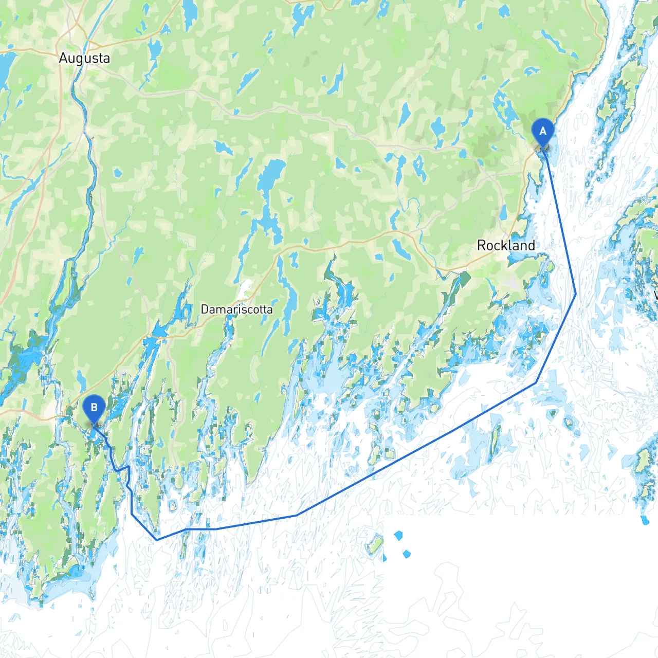
Pilotage Plan from Camden, Maine to Woolwich, Maine
Welcome aboard, fellow boater! You're setting out on an exciting journey from Camden, a picturesque town renowned for its charming harbor, through some of the most stunning coastal landscapes Maine has to offer, ultimately reaching Woolwich. This plan outlines a safe and enjoyable route, highlighting hazards, navigational aids, shelter points, and attractions for your adventure.
Coordinates: -69.0513666667, 44.2106
As you set off, you'll find yourself in Camden Harbor, often described as the “Jewel of the Coast.” Before leaving, check in at the Camden Yacht Club for any local advisories or weather updates. It's vital to have a reliable weather forecast as conditions can change rapidly.
Weather Considerations: Always ensure you have updated weather information. Apps like savvy navvy, which offers real-time weather updates and navigation charts, can be extremely beneficial.
Leg 1: Camden Harbor to Rockport Harbor Distance: Approx. 5 nautical miles
From Camden, you'll navigate southwest towards Rockport Harbor. This stretch is relatively straightforward, but keep an eye out for the offshore islands such as Allen Island, which can create interesting tidal flows. The waters here tend to be busy with fishing boats and local lobster traps, so maintain a vigilant lookout.
Shelter Point: Should the weather turn, Rockport Harbor offers good shelter. It’s a quaint stopoff with small-town charm and local eateries.
Leg 2: Rockport Harbor to Penobscot Bay Distance: Approx. 6 nautical miles
Leaving Rockport, head towards Rockland and into Penobscot Bay. This area can experience significant tidal currents, particularly around the islands and leading into the bay. Familiarize yourself with the Chart 13301 for detailed hazards marked.
Navigational Aids: Look for Rockland Breakwater Light as a fixed landmark to guide you navigationally into the bay.
Leg 3: Penobscot Bay to the Sheepscot River Distance: Approx. 12 nautical miles
As you exit the Bay heading south, the route to the Sheepscot River offers fantastic scenery. Stay westward to avoid the deeper waters. When nearing the mouth of the Sheepscot River, follow marked channels carefully as there are sandbars and shallows.
Shelter Point: If conditions worsen, head for the Warmouth Cove for a tranquil anchorage away from the main currents.
Leg 4: Sheepscot River to Woolwich Distance: Approx. 7 nautical miles
Your final approach takes you along the Sheepscot River, where the landscape transitions into a more rural character. The navigational markers here are prominent; adhere strictly to the channel to avoid shoal waters.
Navigational Aids: Look for red and green channel markers to safely navigate your way to Woolwich. Be aware of recreational boats, kayakers, and fishing vessels operating in this area.
Coordinates: -69.75495, 43.89935
Upon arrival in Woolwich, you’ll find a welcoming community along with access to the various recreational opportunities on the Kennebec River. If you dock your boat, explore the riverbank or find a local diner to enjoy some classic Maine fare.
This route is not only stunningly beautiful but also suited for experienced boaters familiar with navigating new waters and unexpected weather changes. As you embark on this adventure, take time to soak in the serene beauty of Maine's coast while prioritizing your safety and that of the environment. Happy boating!