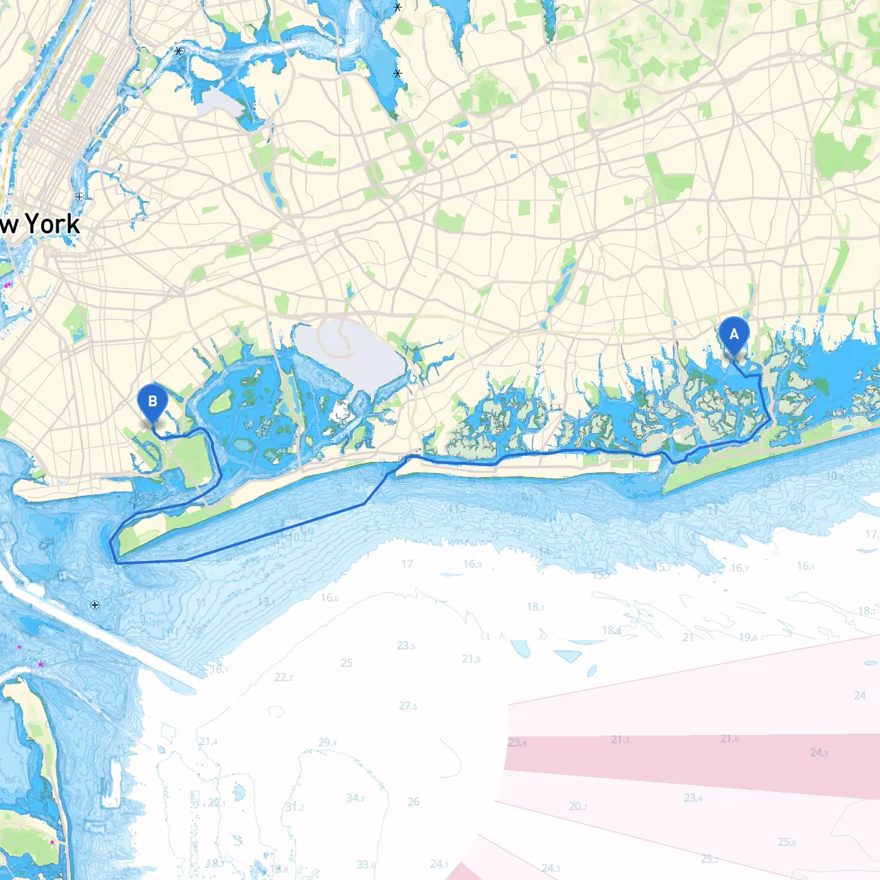
Pilotage Plan: Bellmore, NY to Brooklyn, NY
Start Point: Bellmore, New York (Coordinates: -73.526917, 40.642667) End Point: Brooklyn, New York (Coordinates: -73.918167, 40.608500)
This journey from Bellmore to Brooklyn is a delightful exploration of New York's coastal waters, dotted with scenic views, recreational opportunities, and vibrant local culture. As we navigate from the tranquil waters of Bellmore, through the bustling estuaries, to the diverse urban landscape of Brooklyn, we have to keep safety as our priority, without overlooking the wonders that await along this route.
Starting your journey from Bellmore will have you navigating the serene waters of Bellmore Creek into the larger channels of the South Shore of Long Island. Bellmore's location provides a quick connection to the larger waterways. Be mindful of small craft movements as this area can be busy, especially in the summer months.
As you head west, you will enter the Freeport area. Keep the nautical charts handy as Freeport’s waterways can be tricky with various small craft and fishing boats. Look out for buoy markers which guide you through the more congested areas. Freeport itself offers a quaint atmosphere with dining options and waterfront parks, making it a perfect spot to stretch your legs before continuing your journey.
As you move through the waters, watch for tidal changes that can affect your navigational depth. Be particularly cautious around the Freeport inlet, which is known for its swift currents. Take note of local navigational aids such as buoys and lighthouses. The approach into the inlet is marked clearly, but always maintain a vigilant watch for other vessels.
Should weather conditions change or if choppy waters become too much, Jones Beach Inlet presents a secure anchorage. Here, you can find protection from strong winds, and it’s a scenic spot to await better sailing conditions. The beach offers stunning views and recreational activities—just be sure to check local regulations on anchoring and mooring.
Upon exiting the Freeport area and heading toward Brooklyn, you will pass by the mouth of the Sandy Hook Bay. This waypoint is historically important and visually striking. As you navigate these waters, be sure to look out for other traffic and potential hazards such as fishing nets or small craft movements. Sandy Hook itself features beautiful landscapes, but remember to keep your distance from designated no-wake zones and protected areas.
As you approach Brooklyn, you will transition to the busy waters of New York Harbor. This is where the excitement builds! You will navigate past iconic landmarks like the Statue of Liberty and the Manhattan skyline. It's crucial to keep an eye on the busy traffic patterns; larger vessels have right of way, and avoiding collisions should be of utmost importance.
Throughout your journey, rely on your maps and trusted navigation aids. Make sure your GPS system is updated and functioning properly. It's advisable to also have a good navigation app to guide you efficiently. Consider downloading apps like Savvy Navvy, which provides up-to-date charts, tidal information, and helpful routes for smoother navigation.
You should familiarize yourself with local navigation rules, including speed limits in various zones and guidelines specific to the New York Harbor area. Staying updated on slow or no-wake zones is critical for ensuring safe passage, especially in busy areas.
This route from Bellmore to Brooklyn is perfect for recreational boaters and weekend cruisers who enjoy a mix of tranquility and urban excitement. It caters especially to those who love beautiful scenery and the vibrant culture of New York. By paying attention to safety, recognizing navigational aids, and remaining adaptable to weather changes, you can enjoy a memorable and safe experience on the water. Happy boating!