
savvy charts™ are now available in the Caribbean. Our Caribbean sea map (chart) data is sourced from official hydrographic offices and is blended with our unique style to make them easier and more enjoyable to use. Every Caribbean island is different so why not check out our coverage map here.


Get access to global tidal data sourced from more than eight thousand tide stations around the planet. Our savvy tidal graphs enable you to quickly check the changing high and low tide throughout the day. You can also view tide information and direction by dropping a pin in our tidal stream overlay.

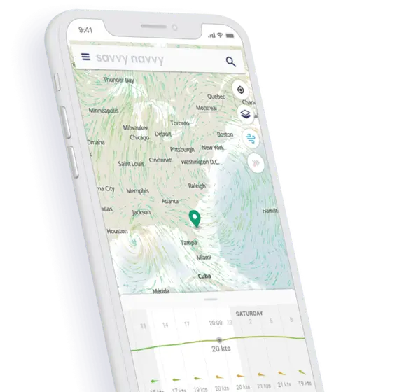
Whether you’re cruising the Caribbean or racing in a RORC event you can easily check your position, COG and SOG, view Caribbean sea maps and critical distances on your phone or tablet at the tap of a screen.


Quickly check the wind strength and direction with our visual wind overlay. Toggle along the graph to change the date and time to see the changing effect of the wind throughout the Caribbean over the next few days.

Use the slider to review the changeable Caribbean weather conditions, wind speed and direction.


Create the perfect route to sail or motor taking into account your boat details, weather conditions and Caribbean sea map (chart) data. Drop a pin at your start and finish locations and savvy navvy will plot the best route given the time, date and conditions.

Whether you plan on arriving island time or on time when you plot a route savvy navvy will display your estimated distance to travel and predicted arrival time, so you can take the guesswork out of getting from A to B.

It’s not always easy to find a fuel dock in the Caribbean. So for greater peace of mind, you can set your cruising speed and fuel efficiency in your boat settings. savvy navvy will then display a predicted fuel usage for your journey in the Caribbean Sea so you can plan ahead and avoid getting caught out.
See at a glance the best time to depart based on your route, wind & tidal conditions, see the demo.
You may not have to worry about tides in the Caribbean but you can still easily view your Course to Steer (CTS) and get a visual overview of your route, instantly with savvy routing™.
Every island is different but that’s no reason not to cruise like a local. Use savvy navvy to check marina and anchorage information, review the seabed holding, VHF numbers, amenities, restaurants, fuel docks and more.
Caribbean nights can be dark, really dark. Toggle to savvy night mode to protect your night vision when cruising the island in the dark. Alternatively switch to satellite mode to take a closer look at your favourite Caribbean harbours, marinas and beaches.
Going off-grid is all part of the fun. Download your chart and weather packs before losing signal to continue using all the great savvy features you love.
Would you like to use your savvy routing™ to view your Caribbean sea maps and passage plans on your boat chart plotter? Then use our “Export Route” feature to download your route as a GPX file which can then be easily uploaded.
savvy navvy have a dedicated customer support team that will support you throughout your Caribbean adventures! Simply use our chat system through the app or contact us at ahoy@savvy-navvy.com.
We don’t restrict charts based on location. So if you’re a savvy navvy member you get access to all our savvy charts™ wherever we have coverage.
Download savvy navvy on your iPhone or iPad today and start planning your next sail.

Download savvy navvy to your Android phone or tablet and supercharge your navigation.

savvy navvy also has seas charts including East Coast USA Charts and Adriatic sea maps


