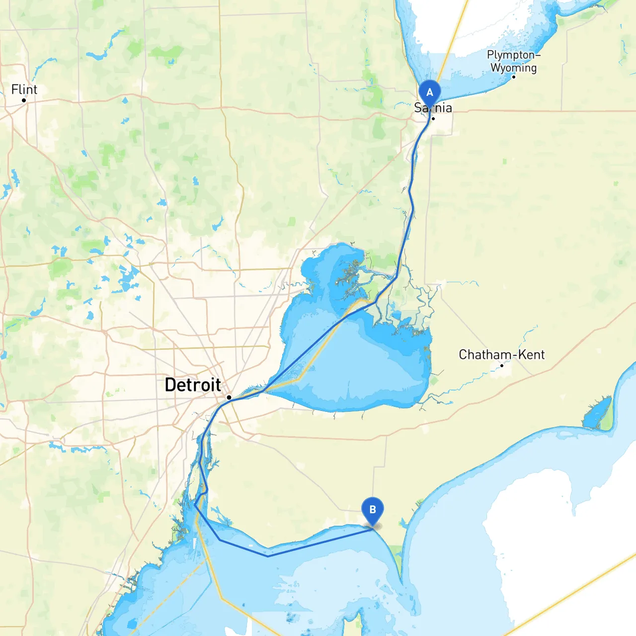
Pilotage Plan: Sarnia, ON to Leamington, ON
Departure Point: Sarnia, Ontario, Canada (Coordinates: -82.4168, 42.99055)
As you set out from Sarnia, you’re departing from a charming city situated at the confluence of the St. Clair River and Lake Huron. The marina here is well-equipped and offers any last-minute provisions you might need. Before you cast off, make sure to check the weather forecast; conditions can change rapidly on the water.
Route Overview:
Your journey to Leamington covers a direct distance of about 50 nautical miles across the scenic waters of Lake Erie. The route will largely trace the shoreline, providing you with splendid views and a wealth of potential stops along the way.
Notable Points of Interest Along the Route:
1. Point Edward Marina (approximately 2 miles from Sarnia): A delightful first stop to stretch your legs. The marina has facilities and is a good place to refuel or grab a bite.
2. Lake St. Clair: As you navigate south, you enter the northern reaches of Lake St. Clair. Keep an eye out for the free-flowing waters and the beautiful islands dotting the area.
3. Pigeon Bay: This hidden gem offers a sheltered anchorage if conditions become unfavorable. It’s a tranquil spot ideal for a lunch break or a quiet rest away from the waves.
4. Chatham-Kent Area: As you cruise, you will have opportunities to witness a variety of wildlife. Pause for a moment to enjoy birdwatching or even venture onshore to explore the small communities dotting the lake's edge.
5. Mitchell’s Bay: If the weather turns foul, this bay is another excellent place to seek refuge. Known for its protected waters, it also provides scenic views and local hospitality.
Arrival Point: Leamington, Ontario, Canada (Coordinates: -82.5962, 42.0257)
As you approach Leamington, prepare to enter a vibrant community known for its beautiful parks and gardens, particularly the Jack Miner Bird Sanctuary, a must-see if you have time. The marina here offers docking facilities and access to local attractions, including the nearby Point Pelee National Park, Canada’s southernmost point.
Navigational Considerations:
1. Navigational Aids: Keep your charts handy. Pay special attention to buoys and markers, particularly as you approach Pigeon Bay and Mitchell's Bay, which are crucial for safe navigation in potentially shallow waters.
2. Local Hazards: Be aware of fluctuating water levels and the potential for debris, especially after storms. Maintain a lookout for fishing boats in the area as well; they can be numerous at times.
3. Weather Considerations: Conditions on Lake Erie can change swiftly. Keeping an eye on both current weather conditions and forecasts will be vital. Should you find yourself facing inclement weather, the bays mentioned previously make viable safe havens.
4. Regulations: Familiarize yourself with local boating regulations, particularly concerning speed limits, no-wake zones, and fishing limits. It’s also critical to notify local authorities if you plan to stay docked overnight.
Recommended Boating Apps:
This journey from Sarnia to Leamington is not just a way to travel; it’s about the stories you craft along the way. With the right precautions, local insights, and awareness of your surroundings, this route promises both safety and beauty—and really, that’s what every boater dreams of. So, gather your crew, enjoy the waters, and make unforgettable memories!