
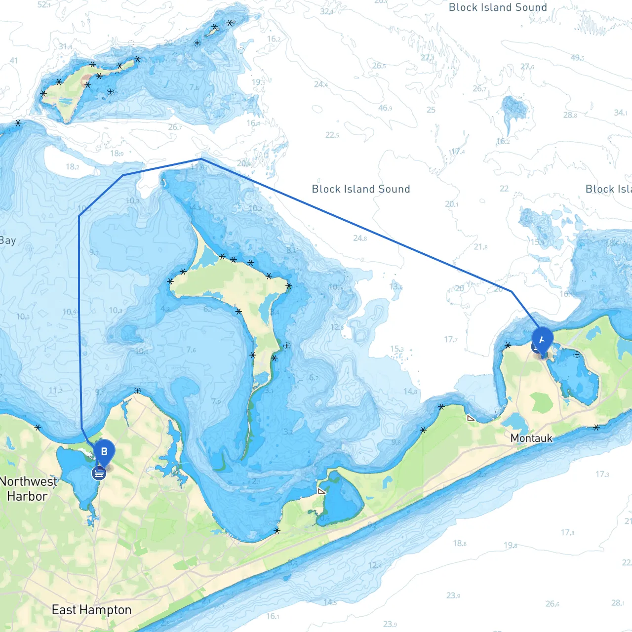
Pilotage Plan: Montauk, NY to Sag Harbor, NY
Departure: Montauk, NY Coordinates: Long -71.938, Lat 41.06767
Your journey begins in the beautiful Montauk Harbor, often referred to as the “End” of Long Island. Before setting out, ensure your vessel is well-prepared and safety gear is on board, including life jackets, flares, and a working VHF radio. Montauk is known for its historical landmarks like the Montauk Point Lighthouse, a great spot for last-minute photos before you set sail.
Safety Considerations: As you depart Montauk, keep an eye on local weather and tide conditions. The waters can become choppy, especially with wind against tide. Always monitor NOAA marine forecasts for any severe weather alerts.
Route Overview: The distance from Montauk to Sag Harbor is approximately 14 nautical miles, which can typically be covered in about two to three hours, depending on your boat's speed and the current conditions.
Navigational Aids and Hazards: As you navigate east from Montauk, you will cross the open waters of the Atlantic Ocean. Key navigational aids include:
1. Montauk Light (Marker 11) - Keep Montauk Light to your northwest as you head towards Sag Harbor.2. Big Reed Pond - Watch for shallow waters and avoid cutting across the sandbars.3. Pigeon Point - This is an important visual landmark. Remember that the currents in this area can be strong, particularly during tidal changes.
Points of Interest Along the Route:
Shelter Areas: As you approach the halfway mark, if conditions begin to worsen, consider diverting to The Gurney's or Lake Montauk where you'll find calmer waters and potential mooring options. Both offer great local dining and relaxation spots.
Entering Sag Harbor: As you get closer to Sag Harbor, you’ll navigate into the bay, where the waters will be more sheltered. Look for the channel markers that will guide you into the harbor. Be cautious of fishing vessels and other recreational boats as you enter this busy area. Look for the charted depths to avoid any grounding.
Arriving at Sag Harbor: Sag Harbor is rich in history and maritime culture. You can dock at one of the local marinas, such as the Sag Harbor Yacht Club or the American Yacht Club. Once docked, you can explore the village's charming shops and restaurants, or visit the Sag Harbor Whaling & Historical Museum.
Final Safety Checks: Before concluding your trip, double-check the weather forecast for the return. Ensure all navigational equipment is functional, and that you have a solid plan for your return journey.
Technology Recommendations: Using a navigation app can enhance your cruising experience. I recommend Savvy Navvy, which provides real-time navigational data and charts tailored for your journey. It’s very user-friendly, especially when you need assistance with navigating tricky waters.
Enjoy your trip! A journey from Montauk to Sag Harbor is not just about getting from point A to B; it’s a wonderful exploration of the stunning coastline and charming harbors of Long Island.