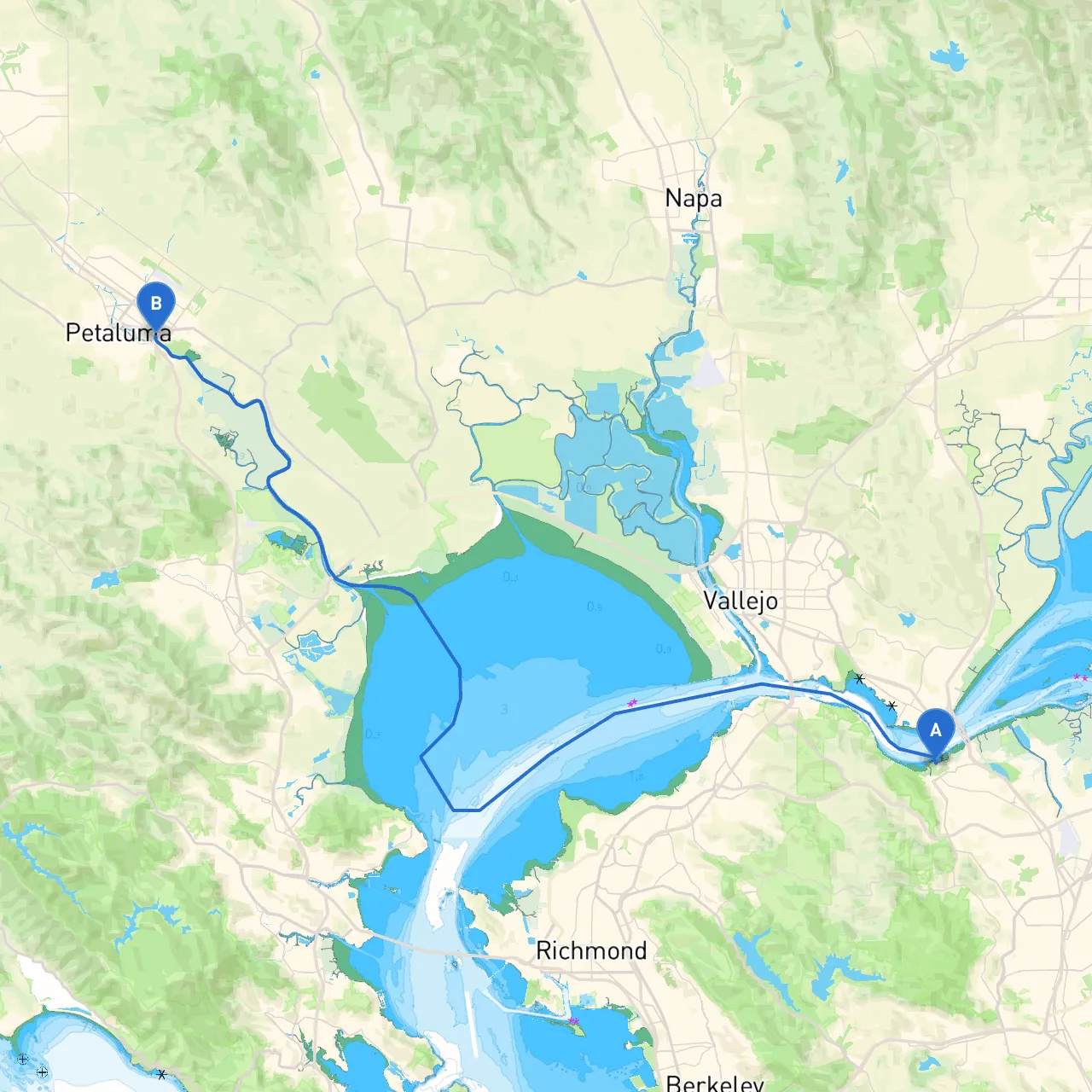
Pilotage Plan: Martinez, CA to Petaluma, CA
Overview:This pilotage plan takes you from Martinez, CA, a quaint marina town on the banks of the Carquinez Strait, to Petaluma, CA, nestled in the picturesque Petaluma River estuary. This is a charming route ideal for skilled sailors and cruisers alike, combining scenic views, fascinating points of interest, and safe harbors, in line with local regulations.
1. Departure from Martinez, CA
Coordinates: -122.1376222372055, 38.02582485469431
As you set out from Martinez, ensure your vessel is well-equipped with safety gear and navigation tools. The Carquinez Strait can be busy with commercial traffic, so sail with vigilance. The Strait is around 2 miles wide, giving you ample space but also great responsibility when it comes to avoiding large vessels.
Hazards: Watch for significant tide changes, and be cautious of shallow areas near the shore, especially as you maneuver out of the concrete harbor. Monitor local weather reports for sudden wind shifts that can make passage tricky.
2. Navigate the Carquinez Strait
As you make your way through the Carquinez Strait, you’ll be surrounded by rolling hills and vistas that highlight Northern California’s beauty. Keep your eyes peeled for the Carquinez Bridge and the Martinez-Benicia Bridge—two local landmarks that add to the charm of this route.
Points of Interest:
Navigation Aids: Listen for navigation beacons. The strait is marked with buoys, so keep your chart handy and observe all markers diligently.
3. Entering San Pablo Bay
Continuing westward, you will enter San Pablo Bay. The bay is an expansive area that can present changing conditions, so be prepared to adjust your sails accordingly. This is also where you should begin to keep a lookout for the mouth of the Petaluma River.
Sheltering Bays: If the weather turns aggressive, consider taking refuge at Point San Pablo to the north, which offers some wind protection.
4. Following the Petaluma River
As you progress south, the entrance to the Petaluma River will come into view. This narrow waterway snakes through beautiful marshland, providing a serene and picturesque experience. The river leads you right into the heart of Petaluma, so adherence to all navigational aids is crucial here.
Hazards: The currents can be swift in the river, particularly during tidal changes, making it essential to navigate carefully.
Local Regulations: Be mindful of speed limits in the river to protect local wildlife, especially migratory birds. The local regulations can be strict, so it’s best to keep your speed in check.
5. Arrival at Petaluma, CA
Coordinates: -122.61351853609084, 38.23045539618204
Upon reaching Petaluma, you’ll be greeted with a vibrant town rich in history and culture. The marina offers easy access to local shops, restaurants, and various points of interest, including historic buildings and a thriving arts scene.
Points of Interest:
Conclusion:
This pilotage plan emphasizes safety while offering rich experiences along the way. The route is particularly suitable for leisure boats, families, and anyone who appreciates the beauty and tranquility of Northern California’s waterways. Always remember to check weather conditions, carry necessary safety equipment, and utilize a reliable navigation app like Savvy Navvy for real-time information and updates.
Enjoy your exploration from Martinez to Petaluma, where adventure awaits with every turn of the tide!