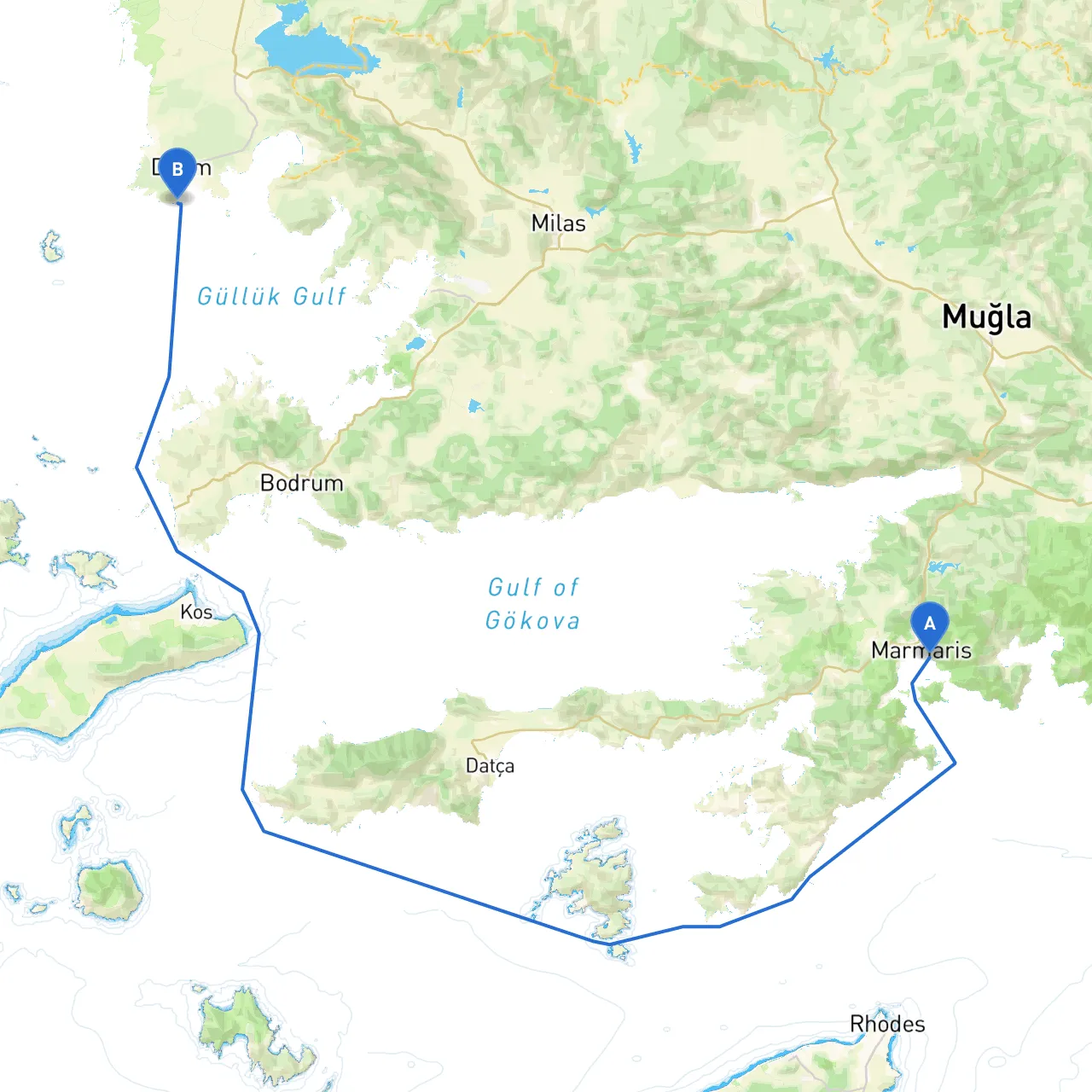
Pilotage Plan from Marmaris, TR to Didim, TR
Departure Point: Marmaris, Muğla Province, Turkey
- Coordinates: 28.28656017780304, 36.844767687030185
- Notable Points: A popular yachting hub known for its stunning marina, vibrant nightlife, and crystal-clear waters. Before setting sail, ensure your vessel is fully equipped and provisioned, as Marmaris can serve as an excellent last stop for supplies.
Destination: Didim, Aydın Province, Turkey
- Coordinates: 27.26158618927002, 37.338401905550946
- Notable Points: Famed for its rich history and proximity to ancient ruins, Didim offers a mix of cultural experiences and scenic coastlines.
Route Overview
The journey from Marmaris to Didim spans approximately 70 nautical miles, making it ideal for a leisurely two-day cruise, allowing time for exploration and unexpected weather adjustments. The route travels along the southwestern coast of Turkey, with a combination of open sea and picturesque bays.
Day 1: Departure from Marmaris
- Course Setting:
Leave Marmaris through the strait of Marmaris Bay, heading southwest towards the Gulf of Hisaronu. This area is relatively sheltered but be cautious of other vessels and watch for local fishing boats.
- Navigational Aids:
Keep an eye on the Marmaris Lighthouse and the buoys marking the navigable channels. The charts are well-marked, but you should consult your electronic navigation systems, especially when entering narrower waterways.
- Shelter Bay—Bodrum's Gökova Bay:
A perfect half-way stop if the weather turns sour. This bay offers nice anchorages and provides a safe haven against sudden wind changes. The surrounding landscape is ideal for a short hike or simply enjoying a quiet day in nature.
- Points of Interest:
You can visit the ancient city of Knidos by making a short detour. It's known for its remarkable ruins and breathtaking views of the Aegean Sea.
Day 2: Continuing to Didim
- Course Setting:
From Gökova Bay, continue your journey heading northeast along the coast. Make sure to avoid the shallow areas by carefully following the nautical charts available.
- Navigational Considerations:
Pay attention to coastal markings and the occasional submerged rocks, especially around the open waters. Utilize your radar overlay if navigating in fog or poor visibility.
- Shelter Bay—Didim Bay:
As you approach Didim, you may wish to stop in Didim Bay (also called Altinkum Bay), which is well-known for its sandy beaches and amenities. It offers a great point to recharge before entering the busy Didim marina area.
- Points of Interest:
Ensure to dedicate time to visit the Temple of Apollo located nearby Didim, an ancient site that is rich in history. And if time allows, local beaches like Altinkum are perfect for swimming or grabbing a bite to eat at a beachside café.
Safety Considerations
- Weather Forecasts: Ensure you check local weather reports regularly and be prepared to change your plans if conditions forecast strong winds or storms.
- Local Regulations: Be mindful of marine sovereignty and local fishing regulations, particularly in areas where fishing is common. Respect any posted no-anchor zones to protect the seabed.
- Emergency Contacts: Have local coast guard and marina numbers handy in case of emergencies.
Recommended Boating Apps
- Savvy Navvy: Offers easy-to-use plotting and navigational features suitable for the Aegean region.
- Navionics: An excellent resource for detailed nautical charts.
- Windy: Provides real-time wind and weather updates crucial for planning your voyage.
This route offers a balance of stunning scenery, interesting cultural sites, and ample opportunities for safe mooring. It caters well to weekend cruisers and experienced sailors alike, blending both adventure and exploration thoughtfully while prioritizing safety and comfort. Happy sailing!