Pilotage Plan: Marblehead, MA to East Boston, MA
Overview
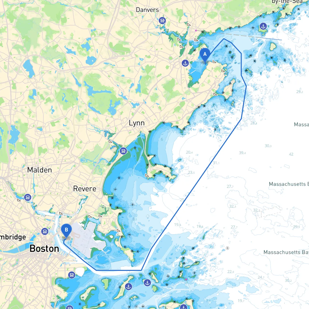
This journey will take you from the scenic harbor of Marblehead, an historic coastal town, to the bustling urban waterways of East Boston. This route is suitable for experienced boaters familiar with navigating in a variety of conditions. You'll be passing through some beautiful waters with plenty of landmarks and safe havens for shelter.
Starting Point: Marblehead, MA
Marblehead’s harbor is known for its picturesque views and rich history. Before leaving, ensure you have checked your weather forecast, as conditions can change rapidly along the coast.
Route Description
As you depart from Marblehead, your first leg will lead you through Marblehead Harbor. Pay close attention to the navigation buoys marking the channel as you navigate out into the open waters.
Leaving Marblehead, you'll be heading southeast towards the entrance of Lynn Harbor. Be cautious of the shoals and the swirling currents in this zone, particularly near the breakwater. Lynn Harbor offers decent shelter and can be a great stop if the weather starts to turn.
Notable Landmarks Along the Way
- Devereux Beach: As you cruise past, enjoy views of this popular beach that can be a great breakout spot for a swim or a quick picnic.
- Nahant Bay: As you approach Nahant Bay, expect to see the historic Nahant Light standing tall. This is a great opportunity for those interested in fishing or just soaking in the views.
After passing Nahant Bay, your route brings you close to the scenic shores of Revere Beach, which is the first public beach in the United States and offers stunning views of the coastline.
Navigational Aids
Pay close attention to:- Baker’s Island Light: This offshore lighthouse can guide you safely through the waters.
- Revere Beach Buoys: They will help you stay within the safe channel as you make your way toward East Boston.
Sheltering Bays
If conditions deteriorate, you have a couple of excellent options for shelter:- Lynn Harbor: Mentioned earlier, it's a safe haven if storms are approaching.
- Winthrop Harbor: Just before you enter the harbor area of East Boston, this location provides good protection from the elements.
Approach to East Boston
As you near East Boston, you’ll enter the Chelsea River. Be on the lookout for heavy traffic as this area is a busy shipping lane. The Logan Airport, on your starboard side, is a prominent landmark to help you orient yourself.
Keep navigation lights handy, as this area can also get congested with marine traffic. Maintain radio contact, especially when approaching the harbor, to avoid any encounters with commercial vessels.
Local Regulations
Before you arrive in East Boston, review local boating regulations. Be aware of no-wake zones, particularly near marinas and residential areas in Winthrop and East Boston. Familiarize yourself with marine traffic control for guidance on navigating the busy channels safely.
Final Destination: East Boston, MA
East Boston is home to a variety of local attractions. From picturesque views of the Boston skyline to waterfront parks, it's worth spending a moment to enjoy the scenery.
Useful Apps for Navigation
For a smooth journey, consider using helpful boating apps like:- Savvy Navvy: Great for route planning and offering real-time weather updates.
- Navionics: Provides detailed charts and waypoints for navigational safety.
- Windy: Excellent for checking wind patterns and forecasts.
The route from Marblehead to East Boston is not just about getting from point A to point B; it’s an opportunity to explore the beautiful coastline of Massachusetts while ensuring safety and compliance with local maritime regulations. Enjoy your trip, stay vigilant, and happy sailing!