Home
 /
Maine
 / 

Kennebunk to Kennebunkport by boat

Kennebunk to Kennebunkport

Distance - 5.8 Nm

Avg Speed
5 kts
10 kts
20 kts
30 kts
Time Estimate
1 hr 8 min
0 hr 34 min
0 hr 17 min
0 hr 11 min
Kennebunk to Kennebunkport

Kennebunk to Kennebunkport

Pilotage Plan from Kennebunk, ME to Kennebunkport, ME

Route Overview

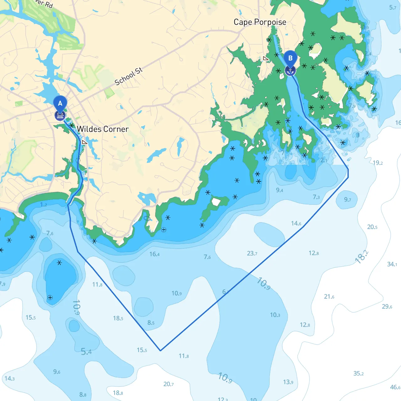
Embarking on a boat trip from Kennebunk, Maine to Kennebunkport offers a unique experience, showcasing the gorgeous Maine coastline. At a distance of approximately 6 nautical miles, this route is particularly suitable for recreational boaters who are looking for a short day trip or those who want to explore local attractions without venturing too far into the open sea.

Starting Point: Kennebunk, ME

Your journey begins at Kennebunk, located at coordinates longitude -70.4780333333 and latitude 43.359. Before setting out, ensure your vessel is in good working condition, check the weather forecast, and have your safety gear ready. Consider the following safety essentials: life jackets, a first aid kit, a marine VHF radio, and proper navigation tools.

Points of Interest:

  • The Kennebunk River runs through the heart of Kennebunk, providing scenic views and wildlife sightings.
  • Nearby, the historic district showcases beautiful architecture and local shops worth exploring.

Route Section: Kennebunk River to the Atlantic

Leaving Kennebunk, follow the Kennebunk River toward the Atlantic Ocean. The river requires careful navigation due to shallow areas and potential currents. You should keep an eye on the following navigational aids:

  • Kennebunk River Buoys: Stay within the marked channel (look for green and red buoys) to avoid grounding.

Shelter Option:

  • Kennebunk River: In case of unexpected weather changes, you can anchor within the river for safe shelter.

Navigational Hazards

As you transition from the river to open water, be aware of the following hazards:

  • Sandbars: These can appear or shift with tides; ensure your charts are up to date (use savvy navvy for real-time updates).
  • Commercial Traffic: Watch for larger vessels as you approach the river's mouth; they can create wakes and be hard to see in certain conditions.

Route from the River into Open Waters

Upon reaching the river's mouth, follow the coordinates to navigate directly to Kennebunkport. As you enter the Atlantic, keep a lookout for:

  • Kennebunkport Light (Gulf of Maine): This picturesque light is a great navigation marker, indicating safe water to enter the harbor.
  • Weather Considerations: The Atlantic can be unpredictable; consider monitoring forecasts using maritime weather apps to ensure safety.

Notable Points of Interest Along the Way

1. Goose Rocks Beach: This beautiful beach area can be approached for a stop. It's a lovely spot for a picnic or a quick swim if you choose to pull up the boat (ensure it's safe to land).

2. Cape Porpoise: Consider making a brief detour here. The harbor is home to various boats and offers lovely views with quaint shopping spots in a charming setting.

3. Kennebunkport Rivermouth: As you approach your destination, you'll enjoy scenic views of beautiful homes lining the shore.

Ending Point: Kennebunkport, ME

Arriving at Kennebunkport, located at coordinates longitude -70.43203063193056 and latitude 43.365535608680915, there are many attractions to enjoy:

  • The lively Dock Square, full of shops and eateries, provides a great opportunity to stretch your legs and indulge in local cuisine.
  • The historic St. Ann's Church and its picturesque surroundings are also worth a visit.

Regulations and Safety Considerations

As always, ensure you adhere to all local navigation laws. Key regulations to be aware of include:

  • No Wake Zones: Certain areas, particularly around docks and residential areas, require slow speeds to minimize disturbances.
  • Fishing Regulations: If you plan to fish, be familiar with local regulations regarding licenses and restricted species.

Final Safety Tips:

  • Always have your life jackets on when under way.
  • Ensure your communications equipment is functional; keeping a charged VHF radio at hand can be a lifesaver.
  • Make use of navigational apps like savvy navvy not only for route planning but also for checking tides and weather updates along the way.

This route promises a fantastic blend of coastal beauty and charm, providing a short yet delightful adventure for any boater looking to explore the Maine coastline safely and enjoyably.

More routes from Kennebunk to Kennebunkport