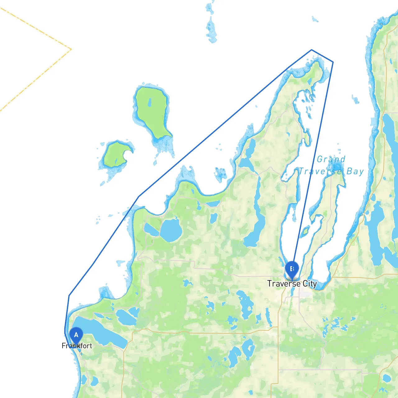
Pilotage Plan: Frankfort, Michigan to Traverse City, Michigan
Route Overview:Embarking on a boat trip from the charming village of Frankfort to the vibrant city of Traverse City presents a delightful opportunity to explore Michigan's beautiful coastline along Lake Michigan. This route, spanning approximately 30 nautical miles, is ideal for both seasoned sailors and adventurous novices, offering picturesque scenery, safe havens, and notable landmarks. As you navigate, safety is paramount, but there are plenty of opportunities to enjoy the journey as well.
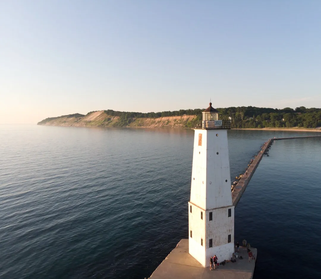
Departure from Frankfort:Begin your adventure in Frankfort, a quaint harbor town recognized for its scenic beaches and historic lighthouse, the Frankfort Light. Before you set sail, ensure your vessel is properly checked and equipped with necessary safety gear—life jackets, flares, and a first aid kit. A quick weather check is crucial as conditions can change rapidly on the lake.
Navigational Aids:As you leave Frankfort Harbor, be mindful of the navigational buoys that mark the entrance. The Frankfort Harbor Lighthouse (located on the north side of the harbor) is a key landmark that signifies safe passage out of the harbor.
Along the Route:As you make your way northward, keep an eye out for the stunning views of the adjacent Sleeping Bear Dunes National Lakeshore. This area is a designated National Lakeshore and is a unique landscape of bluffs, trails, and sandy beaches. A short detour close to shore can allow for a stop at some of these picturesque beaches if the weather permits.
On this stretch, the prominent navigation aids include the Manitou Island Light to the north and several buoys indicating safe channels. Stay vigilant of changing weather patterns as well as any reports concerning fog, as Lake Michigan can experience sudden visibility changes.
Shelter Bays:If unfavorable weather or strong winds arise, you have excellent refuge options:1. Crystal Lake: Just south of your route, this beautiful inland lake is accessible for safety or leisure time. The scenic shores are perfect for a peaceful stop.2. Kettle Bay: Located just past the Crystal Lake, it offers a shallow anchorage but be cautious of navigating into shallower waters. It’s a hidden gem for those seeking shelter.
Points of Interest:
Arrival at Traverse City:As you approach Traverse City, the city's skyline becomes apparent, and you will want to be mindful of the busy harbor traffic. The Betsey’s Bay at the southern edge of Boardman Lake provides calm waters for docking. Keep an eye on the markers guiding you into the harbor, and be aware of local regulations regarding any mooring or anchoring restrictions in the area.
The Grand Traverse Lighthouse to the north will offer an inviting beacon as you enter into the more populous section. Remember to enjoy the bustling activity of local boats and be cautious while maneuvering in the more congested waters near the marina.
Safety and Regulations:Stay updated on local Coast Guard notices for any advisories or temporary restrictions affecting boaters. Always maintain a watch for other vessels and swimmers in key areas such as those around beaches. Use designated channels for communication, especially near busy ports, and adhere to local fishing regulations and rules of the water.
Recommended Apps:To enhance your navigation experience and ensure safety, consider using the following apps:
Conclusion:This pilotage plan sets you on a scenic journey through the heart of Michigan's beautiful waterways. Packed with opportunities for shelter and exploration, this route is suits boaters of various skills—from families seeking adventure to seasoned mariners navigating the breathtaking Lake Michigan. Safe travels on your delightful expedition to Traverse City!