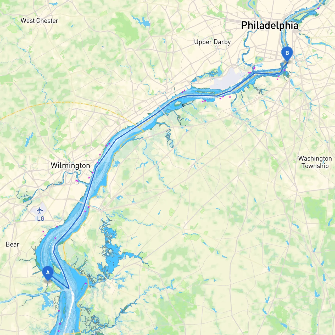
Overview and Suitability This coastal journey from Delaware City, DE, to Gloucester City, NJ, is an ideal adventure for recreational boaters, particularly those with moderate cruising experience. It not only allows you to explore the scenic waterways, but also offers the opportunity to visit charming towns and vibrant locales along the way. Safety is paramount, so this plan emphasizes the need for awareness of hazards, local regulations, and weather conditions while ensuring you have plenty of options for enjoyment.
Starting Point: Delaware City, DE As you set off from Delaware City, you'll navigate through the vibrant waters of the Delaware River Estuary. The initial portion is characterized by residential and industrial shores, so keep a keen lookout for commercial traffic as you proceed.
Key Points and Hazards:
1. Delaware River Shipping Channel Be mindful of the shipping channel, which can be busy with large vessels. Stay clear of the navigation paths marked with buoys and maintain a safe distance.
2. Brandywine and Christina Rivers Intersection These tributaries create an intricate network, providing potential spots for exploration. On cloudy days, visibility can drop, so always keep your navigation lights on and use radar if available.
3. Fort Delaware State Park A recommended stop for a history lesson, this park is located on Pea Patch Island and features guided tours of the historic fort. It’s also a great spot to anchor if the weather changes suddenly.
Mid-Route Navigation Considerations:
After exiting the busy commercial sector, you’ll encounter smoother navigational waters. One of your primary navigation aids will be the Martin Luther King Jr. Memorial Bridge, serving as a visual landmark.
1. New Castle Range Lights As you approach New Castle, keep these lights starboard; they will guide you safely along this section of the route. A strong current can impact boat handling here, especially during peak tidal flows.
2. Wilmington~New Castle Airport Traffic While the airport is nearby, it typically poses no direct hazard; however, it’s wise to be aware of any low-flying aircraft.
3. Enjoying the Waterfront The waterfront areas near Wilmington have beautiful parks and facilities where you might stop for refreshments. Make a note of local restaurants or fuel docks along the way for re-fueling and re-stocking.
1. Mason-Dixon Line Anchorages Look for designated anchorage points along the waterway as you near the Pennsylvania border. They provide peaceful respite in case the weather changes or if you wish to take breaks while enjoying the local scenery.
2. The Delaware Bay Before reaching Gloucester City, you will enter the expanse of the Delaware Bay, where options for sheltered anchorages abound in cases of sudden weather shifts.
3. Reeds Beach A quick detour into Reeds Beach can provide shelter from strong winds while also allowing for fishing opportunities.
Final Approach to Gloucester City, NJ
As you near your destination, keep an eye on local boat traffic. The waters can get busy, but the vibrant character of the port town is welcoming.
1. Gloucester City Bridge Use this bridge as your final waypoint for navigation. Familiarize yourself with any height restrictions if you're on a taller vessel.
2. Gloucester City Waterfront This area boasts various eateries and facilities for boaters—perfect for unwinding after your trip. Plan to drop anchor nearby and explore the local attractions, including parks and historical sites.
This route not only guarantees safe passage but also promises a delightful cruise filled with opportunities for shoreline exploration and local sights. Your adventure awaits at the confluence of responsible boating and the joy of discovery along the beautiful waterways of Delaware and New Jersey.