Pilotage Plan from Clinton, Connecticut to Providence, Rhode Island
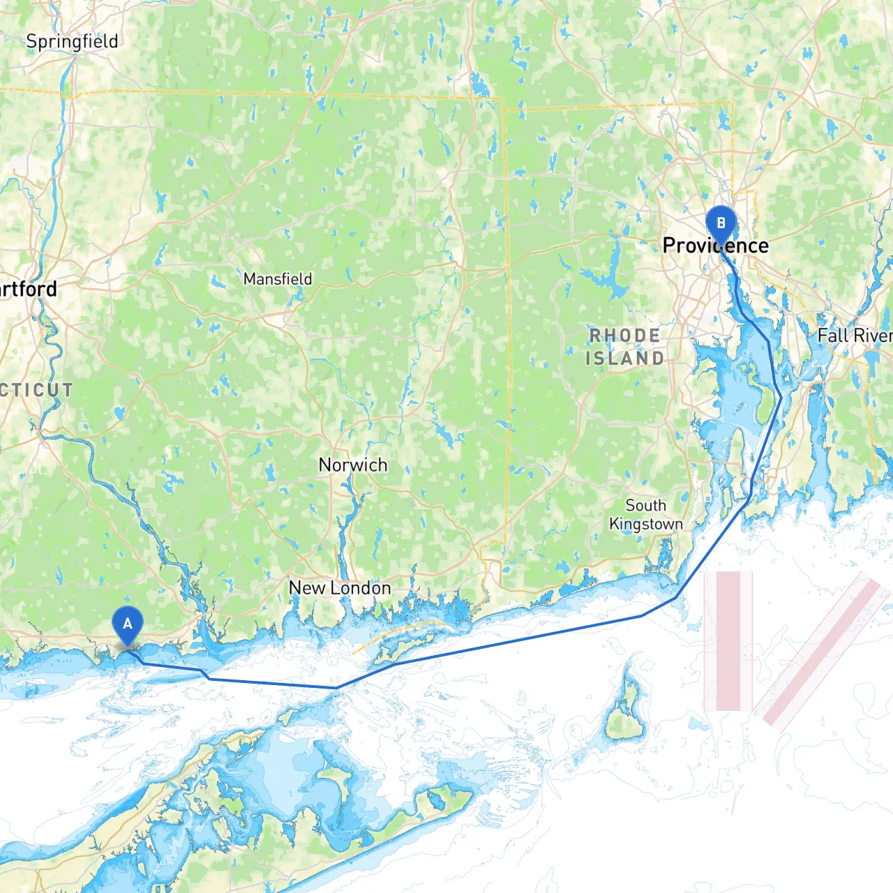
Departure Point: Clinton, Connecticut Your journey begins at the charming town of Clinton, set against the scenic backdrop of the Connecticut coastline. At coordinates (-72.4877, 41.2690), you have access to a welcoming marina and a well-protected harbor that is ideal for setting out on your adventure. Before departing, check the weather; the waters can be dynamic, and local forecasts will inform your trip significantly.
Key Points to Note Before You Leave:
1. Vessel Safety Checks: Ensure all necessary safety equipment (life jackets, flares, fire extinguishers) is onboard and operational. 2. Local Chart: Acquire local navigational charts covering Long Island Sound to Narragansett Bay. Familiarizing yourself with these will assist in avoiding potential hazards.
The Route
Leg 1: Departing Clinton to Saybrook Point
Your first leg will take you northeast, heading towards Saybrook Point. This section is roughly 5 nautical miles, and after a short sail, you’ll enter the Connecticut River's entrance where Saybrook Point light (LLNR 2480) will be a helpful guide. This is a great stop if you need to refuel or restock provisions.
Hazards and Navigation Aids:
- Navigation Aids: Pay close attention to Saybrook Light and the nearby breakwaters, which can pose challenges in choppy conditions.
- Waterway Hazards: Watch for shoals and follow the marked channels to avoid the shallows as you pass by the mouth of the Connecticut River.
Leg 2: Saybrook Point to New London
Continuing your journey, head east past the picturesque shoreline toward New London, approximately 14 nautical miles from Saybrook Point. This stretch offers magnificent views and is popular with boaters.
Points of Interest:
- Fort Trumbull State Park: A historical site where you can explore the remnants of a 19th-century fortification while enjoying a picnic.
Hazards and Aids:
- Lighthouse Navigation: Follow the New London Ledge Light (LLNR 2370) which provides a reliable reference point as you approach the harbor entrance.
- Local Traffic: Be alert for ferry traffic and larger shipping vessels entering and leaving the New London Harbor.
Leg 3: New London to Block Island Sound
Sailing through Block Island Sound (about 15 nautical miles), this leg is known for its scenic beauty but requires careful navigation.
Considerations:
- Weather: Watch local forecasts as conditions can change rapidly.
- Shipping Lanes: Pay attention to congestion caused by fishing boats and larger vessels. The North of the sound awards you stunning views of the coastline.
Leg 4: Entering Narragansett Bay
As you approach the mouth of Narragansett Bay, prepare for a new set of navigation challenges. Once inside the bay, your destination—Providence—is about 13 nautical miles up the bay.
Notable Shelters:
- Bays to Consider: Should the weather take a turn for the worse, consider seeking shelter at Bristol Harbor or Warren, both of which have marinas that provide safe havens.
Navigation Points:
- Floating Aids: You will encounter numerous buoys and markers that delineate the shipping channels into Providence. Keep a keen eye on your GPS and local charts during this segment.
Arrival at Providence, Rhode Island
Your adventure culminates in Providence, a vibrant city known for its rich culture and history. At coordinates (-71.4023, 41.8175), you’ll find well-situated marinas that are perfect for docking. Enjoy visits to local attractions like the WaterFire exhibits or take in the local cuisine at waterfront restaurants.
Final Recommendations
Before embarking on your journey, ensure you have the following boating apps handy:- Savvy Navvy: A great tool for navigation and planning.
- Navionics: Provides detailed charts (especially useful in Narragansett Bay).
- Windy: For monitoring weather conditions along your route.
This itinerary is perfect for experienced boaters looking to enjoy a well-rounded experience of coastal New England's natural beauty while maintaining a focus on safety. The enclosed waters of Long Island Sound and Narragansett Bay allow for a comfortable cruise, ensuring both relaxation and excitement during your trip. Safe travels!