
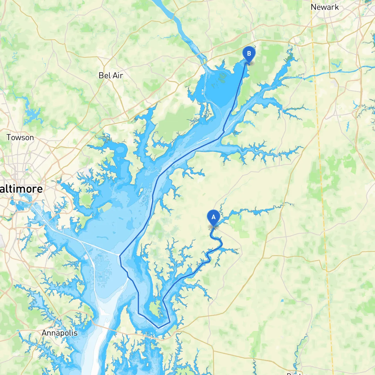
Embarking on a cruising adventure from Chestertown to North East, this journey covers approximately 25 nautical miles through the beautiful waters of the Chesapeake Bay region. This route is particularly suitable for intermediate to experienced boaters, given the presence of navigational aids and the occasional complexities presented by local waterways.
1. Departure from Chestertown, Maryland - Coordinates: (Long: -76.06167, Lat: 39.20500) - Before setting off, ensure that all navigation tools, safety gear, and communication devices are in good working order. Check the local weather forecast to plan your departure, as conditions can change rapidly on the Bay.
2. Navigating to the Chester River Entrance - Upon leaving Chestertown, set a course northeast towards the Chester River. Maintain a vigilant eye for any local traffic, as this waterway can be busy with fishing boats and recreational vessels. - Keep to the marked channel to avoid any shallow spots. The Chester River is known for its picturesque surroundings and you'll have scenic views of lush landscapes.
3. Hazard Awareness - Pay attention to the Chester River Spit — a sandbar that could pose a risk at low tide. Regularly check tide charts to gauge water levels, particularly when passing through shallower areas.
4. Shelter at Great Oak Landing - A great stopping point is Great Oak Landing. If the weather turns sour, this small harbor offers good shelter, making it a feasible place to anchor overnight or wait out a storm. - Facilities here are limited but do offer a chance to stretch your legs with a small beach and walking trails.
5. Approaching the Bay and Navigational Aids - As you leave the Chester River and head towards the Chesapeake Bay, you will pass The Chesapeake Bay Bridge. This iconic structure is not only a landmark but also a navigational reference point. Maintain a safe distance from bridge supports and watch for the traffic from boats navigating beneath it. - Use the Chesapeake Bay Buoy system (such as such as CB 72) as a guide to help stay clear of deeper shipping channels.
6. Bays Along the Way - One of the standout features for stopping along the way is Sassafras River, which is slightly off your path but could be worth a detour. It has a beautiful anchorage area and is frequently less crowded. Ideal for picnics, fishing, and leisurely exploration.
7. Final Approach to North East, Maryland - The entrance to the North East River is well-marked. Be sure to keep watch for the North East River Lighthouse which serves as a helpful waypoint. The river is also an excellent point for local wildlife observation, particularly during migration seasons.
8. Arrival at North East, Maryland - Coordinates: (Long: -75.96278, Lat: 39.55805) - Once you’ve arrived, enjoy local attractions such as quaint shops and waterfront dining. The North East Community Park is ideal for a short stroll or a picnic.
This route provides a compelling blend of scenic beauty, adventure, and necessary safety measures, ideal for boaters looking to explore Maryland’s waterways. Enjoy the tranquility of the Chesapeake Bay while remaining aware of local regulations and environmental conditions. Safe travels!