
Pilotage Plan: Bayside, NY to Leonardo, NJ
Overview
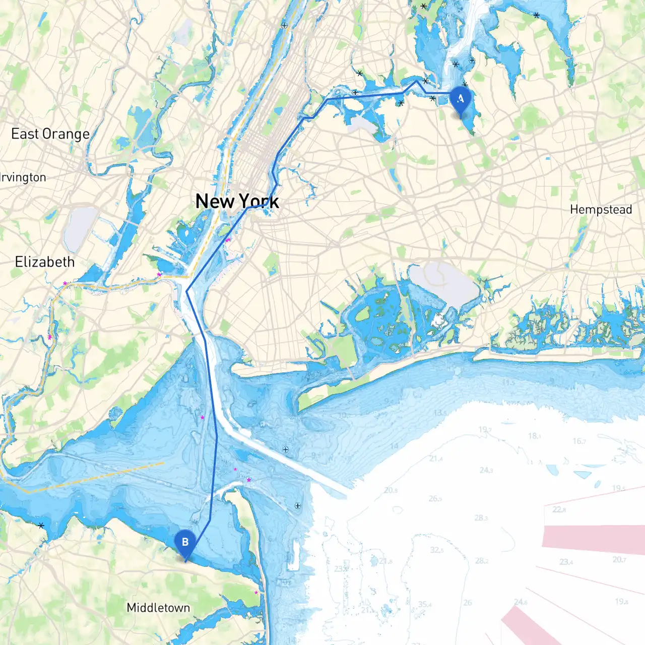
This exciting trip from Bayside, NY to Leonardo, NJ presents an exceptional opportunity for boaters looking for coastal navigation. The journey spans approximately 40 nautical miles and is well-suited for experienced sailors. Its engaging landscape, charming marinas, and the occasional urban vista make this passage not only safe but also memorable.
Starting Point: Bayside, NY
Bayside is nestled in the northeastern section of Queens, providing excellent access to the waters of Long Island Sound. Before you set off, it’s wise to check local weather conditions. This area can experience sudden changes in weather, particularly in the spring and fall months.
Route Description
As you leave Bayside, your route will take you south into the Upper Bay of New York Harbor. Follow the navigation buoys that guide you toward the Ambrose Channel. It's essential to monitor your nautical charts and GPS, as these waters can be busy with commercial vessel traffic.
Hazards to Consider
Be mindful of the following hazards along the route:
Tidal Currents: The East River and Hudson River can have strong currents. It is advisable to plan your passage around slack water.
Fishermen and Commercial Vessels: This area can be busy with boats; vigilance is crucial. Make sure to maintain a safe distance and adhere to the navigational rules of the road.
Shallow Areas: Be cautious around Sandy Hook Bay, where shoals can form, especially during low tide.
Points of Interest
Whitestone Bridge: As you head south, the iconic Whitestone Bridge will come into view. Make sure to take a moment to appreciate this landmark—it’s a beautiful spot for photography.
Jamaica Bay Wildlife Refuge: If you choose to take a detour, this refuge is an excellent stop for nature lovers. It’s a manageable short sail, and you can enjoy bird-watching and walking trails.
Sandy Hook: This barrier beach offers a scenic vista and historical sites. You can anchor here if the weather permits, providing an outstanding place to stretch your legs.
Navigation Aids
As you navigate south, keep an eye on the following aids:
Navigation Markers: Pay close attention to the numerous buoys and markers leading you through the East River and into lower New York harbor. Familiarize yourself with their meanings regarding safe passage.
Charts and GPS: Always have a reliable chart and navigating app ready, especially savvy navvy, which offers real-time navigation and information on weather, tides, and anchorages.
Shelters and Safe Havens
In case of deteriorating weather conditions, the following areas can provide safe harbors:
Great Kills Harbor: Situated on Staten Island, this well-protected harbor offers numerous facilities, making it an excellent refuge.
Sandy Hook Bay: Along the journey before reaching Leonardo, this bay can provide some shelter from incoming squalls.
Regulations and Local Considerations
Make sure you are aware of:
No Wake Zones: Pay particular attention to areas marked as no-wake zones, especially around marinas and harbors.
Vessel Traffic Safety: The waters around New York and New Jersey require a high level of navigational awareness due to the busy maritime traffic. Use VHF Radio to stay informed regarding traffic, especially near the verged waters.
Ending Point: Leonardo, NJ
Upon arrival in Leonardo, you’ll find a charming community with marinas and easy access to local amenities. Here, you can refuel, dock, and enjoy the local attractions.
Conclusion
This route from Bayside to Leonardo is perfect for seasoned boaters looking to balance safety with adventure. Always prioritize safety, respect the waterways, and keep an eye on the ever-changing weather conditions. With stunning views, fascinating landmarks, and the potential for memorable encounters, this journey is a wonderful way to experience the varied landscape of the New York-New Jersey coastline. Make sure to have your charts, savvy navvy app, and a good sense of adventure ready for a delightful day on the water!